Scotland Island

Last updated

Aerial view of a part of Sydney's Northern Beaches, with Pittwater and Scotland Island on the left Aerial view of Sydney Northern Beaches.jpg
Aerial view of a part of Sydney's Northern Beaches, with Pittwater and Scotland Island on the left

Scotland Island is an island and suburb on the Northern Beaches of Sydney, in the state of New South Wales, Australia. Church Point, Scotland Island's major mainland service locality, is located 32 kilometres north of the Sydney central business district, in the local government area of Northern Beaches Council.

Contents

Geography and geology

Scotland Island is located in Pittwater, off Church Point. The island is approximately 1 km in diameter and its highest point is over 90 metres above sea level. To the east is the suburb of Newport, west is Ku-ring-gai Chase National Park, and south are the suburbs of Church Point and Bayview.

Around 18,000 years ago Scotland Island was a hill in a river valley. Following the last ice age, sea levels rose, flooding the valley, forming Pittwater and creating the island. There are many small beaches, consisting mainly of mud, mangroves and rocks. There are no rivers or cliffs, but some small caves towards the top of the island. The top of the island is sandstone and the lower part consists of sedimentary rocks from the Narrabeen group. [1]

History

Scotland Island, Pittwater5.jpg

For thousands of years prior to European settlement, Scotland Island and the Pittwater area was inhabited by the Guringai people. [2]

Shortly after the establishment of the penal colony at Sydney Cove, the area was explored by Governor Phillip, who named the island after William Pitt, the British prime minister at the time. The first European settler to own land on the island was Andrew Thompson, who renamed it Scotland Island after his homeland. He created a successful salt works and built boats until his death in 1810. The island as a whole was sold several times in the nineteenth century before being sub-divided and sold off in lots in 1906. Around 1900, salt was still being extracted from seawater near what is now known as Tennis Court Wharf. Using an oil burner, about 90 kg were extracted each week. [2]

Sheep farms had been located on the island at one time, but permanent residents began to move in after power was connected in 1962. [2] Now, the majority of people living there commute to work on the mainland.

There are many Aboriginal Middens on the island including one in Catherine Park, here you will find many shells and other artifacts. The Midden is estimated at 3500 years old. The tree there was also planted by the local Aboriginal people. All Aboriginal cultural places in NSW are protected by law. Aboriginal artefacts are also protected. It is against the law to disturb or destroy an Aboriginal place. Artefacts should not be removed from site.

Community

Scotland Island is one of two inhabited islands in the Sydney area. The island is accessed by the Church Point Ferry and private vessels. Most of the island consists of bushland, with a residential zone of about 350 houses around the perimeter foreshore. There are no shops, cafes or industrial zones.

The jetty in Scotland Island Scotland Island, Pittwater3.jpg
The jetty in Scotland Island

The non-residential buildings are a kindergarten, Community Hall and Fire Station. The Child Centre and Community Hall were built by the residents in the 1980s and 1990s and are used for various purposes.[ citation needed ] Community groups on the island include a regular discussion group and an international folk dancing group. In 2006, an arts and film festival was organised on the island by the community. A fire in an art gallery in neighbouring Newport destroyed a collection of artworks created by artists living on Scotland Island and the offshore communities of Pittwater.[ citation needed ]

There is no road access to the island, so the volunteer fire brigade fulfill a number of essential services normally performed by full-time emergency service personnel in other areas of Sydney. The Scotland Island Rural Fire Brigade (SIRFB) is made up of volunteers: about 30 active (firefighting) members and about another 30 associate (non-firefighting) members.[ citation needed ]

In the 2021 census, there were 711 people on Scotland Island. 63.2% were born in Australia, the next most common countries of birth included England 9.4%, New Zealand 3.1%, the United States of America 2.7%, Canada 1.3%, and France 1.1%. 84% spoke only English at home, the next most common languages spoken at home included German 2.3%, French 2.1%, Italian 1.4%, Spanish 0.7%, and Portuguese 0.6%. The most common responses for religion were No Religion 61%, Catholic 12%, Anglican 9.1% and Uniting Church 1.5%; a further 7.7% of respondents elected not to disclose their religion. [3]

Scotland Island is a renowned hub for Sydney artists and musicians. Notable residents include Continental Rob Suzs from 1980s Sydney soulsters, The Dynamic Hepnotics, and blues and roots singer Jackie Marshall.

Notable residents

Scotland Island was used as a location in Australian mystery/crime writer Peter Corris novel "The Greenwich Apartments", [6] but was renamed Shetland Island.

Climate

Climate is characterised by relatively high temperatures and evenly distributed precipitation throughout the year. Summers are usually somewhat wetter than winters, with much of the rainfall coming from convectional thunderstorm activity. The Köppen Climate Classification subtype for this climate is "Cfa" (Humid Subtropical Climate). [7]

Climate data for Scotland Island, New South Wales
MonthJanFebMarAprMayJunJulAugSepOctNovDecYear
Mean daily maximum °C (°F)26
(78)
26
(78)
24
(76)
22
(72)
19
(66)
17
(62)
16
(60)
17
(63)
19
(67)
22
(71)
23
(74)
25
(77)
21
(70)
Mean daily minimum °C (°F)18
(65)
18
(65)
17
(63)
14
(58)
11
(52)
9
(48)
8
(46)
9
(48)
11
(51)
13
(56)
15
(59)
17
(63)
13
(56)
Average precipitation mm (inches)99
(3.9)
110
(4.3)
130
(5.1)
120
(4.7)
120
(4.7)
130
(5.1)
89
(3.5)
71
(2.8)
58
(2.3)
71
(2.8)
81
(3.2)
71
(2.8)
1,150
(45.2)
Source: Weatherbase [8]

Related Research Articles

<span class="mw-page-title-main">Ku-ring-gai Chase National Park</span> Protected area in New South Wales, Australia

Ku-ring-gai Chase National Park is a national park on the northern side of Sydney in New South Wales, Australia. The 14,977-hectare (37,010-acre) park is 25 kilometres (16 mi) north of the Sydney central business district and generally comprises the land east of the M1 Pacific Motorway, south of the Hawkesbury River, west of Pittwater and north of Mona Vale Road. It includes Barrenjoey Headland on the eastern side of Pittwater.

<span class="mw-page-title-main">Palm Beach, New South Wales</span> Suburb of Sydney, New South Wales, Australia

Palm Beach is a suburb in the Northern Beaches region of Greater Sydney, in the state of New South Wales, Australia. Palm Beach is located 41 kilometres (25 mi) north of the Sydney central business district, in the local government area of Northern Beaches Council. Palm Beach sits on a peninsula at the end of Barrenjoey Road near Pittwater and is the northernmost beach in the Greater Sydney Metropolitan area. The population of Palm Beach was 1,593 as at the 2016 census.

<span class="mw-page-title-main">Northern Beaches</span> Region in New South Wales, Australia

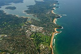
The Northern Beaches is a region within Northern Sydney, in the state of New South Wales, Australia, near the Pacific coast. This area extends south to the entrance of Port Jackson, west to Middle Harbour and north to the entrance of Broken Bay. The area was formerly inhabited by the Garigal or Caregal people in a region known as Guringai country.

<span class="mw-page-title-main">Pittwater Council</span> Former local government area in New South Wales, Australia

Pittwater Council was a local government area on the Northern Beaches of Sydney, in the state of New South Wales, Australia. It covered a region adjacent to the Tasman Sea about 30 kilometres (19 mi) north of the Sydney central business district. The area is named after Pittwater, the body of water adjacent to much of the area governed. First proclaimed in 1906 as the A Riding of Warringah Shire, the area was proclaimed as the Municipality of Pittwater on 1 May 1992. On 12 May 2016, the Minister for Local Government announced that Pittwater Council would be subsumed into the newly formed Northern Beaches Council. The last mayor of Pittwater Council was Councillor Jacqui Townsend, an independent politician.

<span class="mw-page-title-main">Hunters Hill, New South Wales</span> Suburb of Sydney, New South Wales, Australia

Hunters Hill is a suburb of Northern Sydney, in the state of New South Wales, Australia. Hunters Hill is located 9 kilometres (5.6 mi) north-west of the Sydney central business district and is the administrative centre for the local government area of the Municipality of Hunter's Hill.

Dobroyd Head is a point or headland in the Northern Beaches local government area, in the suburb of Balgowlah Heights, New South Wales, Australia. It is part of the Sydney Harbour National Park, which contains examples of ecosystems at risk such as coastal heath. Tania Park is located to the immediate north-east, and contains the 2MWM 90.3 transmitter. There is a lookout sited on the headland named after Arabanoo, the first Aboriginal man to live among European settlers who was captured in Manly Cove in 1788.

<span class="mw-page-title-main">Collaroy, New South Wales</span> Suburb of Sydney, New South Wales, Australia

Collaroy is a suburb in northern Sydney, in the state of New South Wales, Australia. Collaroy is 22 kilometres north-east of the Sydney central business district, in the local government area of Northern Beaches Council. It is part of the Northern Beaches region. Nicknamed "The Roy" by many of the locals.

<span class="mw-page-title-main">Dee Why</span> Suburb of Sydney, New South Wales, Australia

Dee Why is a coastal suburb of northern Sydney, in the state of New South Wales, Australia, 18 kilometres north-east of the Sydney central business district. It is the administrative centre of the local government area of Northern Beaches Council and, along with Brookvale, is considered to be the main centre of the Northern Beaches region.

Elanora Heights is a suburb in northern Sydney, in the state of New South Wales, Australia. Elanora Heights is 27 kilometres north-east of the Sydney central business district, in the local government area of Northern Beaches Council. Elanora Heights is part of the Northern Beaches region.

<span class="mw-page-title-main">Mona Vale, New South Wales</span> Suburb of Sydney, New South Wales, Australia

Mona Vale is a suburb of Sydney, in the state of New South Wales, Australia. It is located 28 kilometres north of the Sydney central business district, in an area known as the Northern Beaches. Formerly the administrative centre of Pittwater Council, it is now located in the local government area of Northern Beaches Council. The traditional custodians of the area are the Garigal people. It is often colloquially referred to as "Mona".

<span class="mw-page-title-main">Pittwater</span> Estuary in Sydney, Australia

Pittwater is a semi-mature tide dominated drowned valley estuary, located about 40 kilometres (25 mi) north of the Sydney central business district, New South Wales, Australia; being one of the bodies of water that separate greater Metropolitan Sydney from the Central Coast.

<span class="mw-page-title-main">Queenscliff, New South Wales</span> Suburb of Sydney, New South Wales, Australia

Queenscliff is a suburb of northern Sydney, in the state of New South Wales, Australia. Queenscliff is located 16 kilometres north-east of the Sydney central business district, in the local government area of Northern Beaches Council and is part of the Northern Beaches region.

<span class="mw-page-title-main">Newport, New South Wales</span> Suburb of Northern Beaches Council, New South Wales, Australia

Newport is a suburb of northern Sydney in the state of New South Wales, Australia, in the local government area of Northern Beaches Council. It is part of the Northern Beaches region.

<span class="mw-page-title-main">Church Point, New South Wales</span> Suburb of Sydney, New South Wales, Australia

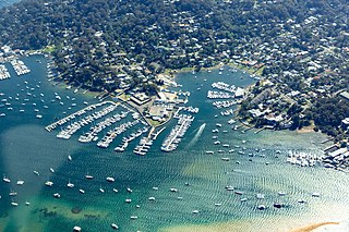
Church Point is a suburb in the Northern Beaches region of Sydney, in the state of New South Wales, Australia. Church Point is 32 kilometres north of the Sydney central business district, in the local government area of Northern Beaches Council.

<span class="mw-page-title-main">Clareville, New South Wales</span> Suburb of Sydney, New South Wales, Australia

Clareville is a suburb in northern Sydney, in the state of New South Wales, Australia. Clareville is 36 kilometres north-east of the Sydney central business district, in the local government area of Northern Beaches Council. Clareville is part of the Northern Beaches region.

<span class="mw-page-title-main">Coasters Retreat, New South Wales</span> Place in New South Wales, Australia

Coasters Retreat is a road-inaccessible suburb in northern Sydney, in the state of New South Wales, Australia, 42 kilometres north of the Sydney central business district, in the local government area of Northern Beaches Council.

<span class="mw-page-title-main">Kristina Keneally</span> Australian politician (born 1968)

Kristina Marie Kerscher Keneally is an American-born Australian politician who served as the first female Premier of New South Wales from 2009 to 2011 and was later a Labor Senator for New South Wales from February 2018 until April 2022. She resigned from the Senate to contest the House of Representatives seat of Fowler, but was unsuccessful. From 2019 to 2022 she served as Deputy Leader of the Opposition in the Senate, Shadow Minister for Home Affairs, and Shadow Minister for Immigration and Citizenship.

<span class="mw-page-title-main">Elvina Bay</span> Suburb of Sydney, New South Wales, Australia

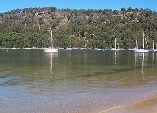
Elvina Bay is a bay and an adjacent suburb in northern Sydney, in the state of New South Wales, Australia. It is located 35 kilometres north of the Sydney central business district, in the local government area of Northern Beaches Council.

<span class="mw-page-title-main">Lovett Bay</span> Suburb of Sydney, New South Wales, Australia

Lovett Bay is a suburb and adjacent bay in northern Sydney, in the state of New South Wales, Australia. It is 36 kilometres north of the Sydney central business district, in the local government area of Northern Beaches Council.

<span class="mw-page-title-main">Barrenjoey Head Lighthouse</span> Lighthouse in New South Wales, Australia

The Barrenjoey Head Lighthouse is a heritage-listed lighthouse at Barrenjoey Headland in the Sydney suburb of Palm Beach, New South Wales, Australia. It was designed by James Barnet, the New South Wales Colonial Architect and built by Isaac Banks. It is also known as Barrenjoey Head Lightstation. The property is owned by Office of Environment and Heritage, an agency of the Government of New South Wales. The lightstation was added to the New South Wales State Heritage Register on 2 April 1999.

References

  1. John Martyn. "Towards a Richer Understanding of Local Geology,STEP INC, Retrieved February 22nd, 2018".
  2. 1 2 3 "A Piece of Scotland Island History – Catherine Park Pittwater timeline". Scotland Island Community Website. Retrieved 8 September 2021.
  3. Australian Bureau of Statistics (28 June 2022). "Scotland Island". 2021 Census QuickStats. Retrieved 4 March 2024. OOjs UI icon edit-ltr-progressive.svg CC-BY icon.svg Material was copied from this source, which is available under a Creative Commons Attribution 4.0 International License.
  4. Macken, Lucy; Duke, Jennifer (15 November 2017). "Kristina Keneally buys a Scotland Island hideaway for $1.8 million". Domain . Archived from the original on 9 June 2024. Retrieved 19 February 2018.
  5. Knott, Matthew (21 March 2022). "Kristina Keneally goes on south-west Sydney charm offensive" . The Sydney Morning Herald . Archived from the original on 9 June 2024. Retrieved 1 April 2022. At the time Keneally and husband Ben were living 55 kilometres away on the exclusive northern beaches enclave of Scotland Island.
  6. Corris, Peter (1986), The Greenwich apartments, Unwin Paperbacks, ISBN   978-0-04-820030-3
  7. Climate Summary for Scotland Island, New South Wales
  8. "Weatherbase.com". Weatherbase. 2013. Retrieved on 13 July 2013.

33°38′24″S151°17′28″E / 33.64000°S 151.29111°E / -33.64000; 151.29111