
Glenbawn Dam is a major ungated earth and rock fill with clay core embankment dam with concrete chute spillway plus fuse plugs across the Hunter River upstream of Aberdeen in the Hunter region of New South Wales, Australia. The dam's purpose includes flood mitigation, hydro-electric power, irrigation, water supply and conservation. The impounded reservoir is called Lake Glenbawn.

The Stephens Creek Dam is an earth-filled embankment dam built on a rock foundation with an uncontrolled spillway across the Stephens Creek, located in the Far West region of New South Wales, Australia. The principal purpose of the dam is to supply potable water for the town of Broken Hill. The impounded 2,000-megalitre reservoir is called Stephens Creek Reservoir.
Glennies Creek Dam is a minor ungated concrete faced curved earth and rockfill embankment dam with an uncontrolled rock cut spillway across the Glennies Creek, upstream of Singleton, in the Hunter region of New South Wales, Australia. The dam's purpose includes flood mitigation, irrigation, water supply and conservation. The impounded reservoir is called Lake Saint Clair.

Googong Dam is a minor ungated earth and rock fill with clay core embankment dam with concrete chute spillway plus a nearby 13 metres (43 ft) high earthfill saddle embankment across the Queanbeyan River upstream of Queanbeyan in the Capital Country region of New South Wales, Australia. The dam's purpose includes water supply for Canberra and Queanbeyan. The impounded reservoir is called Googong Reservoir.

Cochrane Dam is a minor earthfill embankment dam with concrete spillway across Georges Creek, located in the South Coast region of New South Wales, Australia. The main purpose of the dam is to supply water for hydro-power at the downstream Brown Mountain Power Station and for irrigation purposes. The impounded reservoir is called Cochrane Lake.

The Little Nerang Dam is a concrete gravity dam with an un-gated spillway across the Little Nerang Creek that is located in the South East region of Queensland, Australia. The main purpose of the dam is for potable water supply of the Gold Coast region. The impounded reservoir is also called Little Nerang Dam. The dam was closed to the public in 2013 due to safety concerns.

The Ross River Dam is a rock and earthfill-filled embankment dam across the Ross River, located between Kelso and Mount Stuart in the City of Townsville in northern Queensland, Australia. Built initially for flood control, Lake Ross, the impoundment created by the dam, serves as one of the major potable water supplies for the region.

Spring Creek Dam is a minor embankment dam across the Spring Creek upstream of Orange in the central western region of New South Wales, Australia. The impounded reservoir is called the Spring Creek Reservoir.

Split Rock Dam is a minor ungated concrete faced rock fill embankment dam with concrete chute spillway across the Manilla River upstream of Manilla in the north-western slopes region of New South Wales, Australia. The dam's purpose includes flood mitigation, irrigation, water supply and conservation. The impounded reservoir is called Split Rock Reservoir.
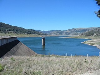
Pindari Dam is a minor concrete faced rockfill embankment dam with an ungated uncontrolled rock cut with concrete sill spillway across the Severn River located upstream of the town of Ashford, in the North West Slopes region of New South Wales, Australia. The dam's purpose includes flood mitigation, hydro-power, irrigation, water supply and conservation. The impounded reservoir is called Lake Pindari.

Clarrie Hall Dam is a minor ungated concrete faced rockfill embankment dam with an uncontrolled concrete-lined chute spillway across the Doon Doon Creek, located upstream of the small town of Uki, in the Northern Rivers region of New South Wales, Australia. The main purpose of the dam is for water supply and it creates the artificial Lake Clarrie Hall.

Toonumbar Dam is a minor ungated rock fill with clay core embankment dam with a concrete chute spillway across the Iron Pot Creek north-west of Casino in the Northern Rivers region of New South Wales, Australia. The dam's purpose includes hydro-power, irrigation, water supply, and conservation. The impounded reservoir is called Lake Toonumbar.

The Cotter Dam is a concrete gravity and rockfill embankment dam across the Cotter River, located in the Australian Capital Territory, Australia. The impounded Cotter Reservoir is a supply source of potable water for the city of Canberra and its environs.
Ben Chifley Dam, or Chifley Dam, is a rock and earth-fill embankment dam across the Campbells River in the central west region of New South Wales, Australia. The main purpose of the dam is to supply potable water to the city of Bathurst.
Oberon Dam or Fish River Dam is a major ungated concrete slab and buttress with earth embankment dam comprising a concrete ski jump chute spillway and fuse plug across the Fish River upstream of Oberon in the Central Tablelands region of New South Wales, Australia. The dam's purpose includes flood mitigation, industrial, and water supply. The impounded reservoir is called Lake Oberon.
Brogo Dam is a minor ungated rockfill embankment dam with an uncontrolled unlined rock cut spillway across the Brogo River upstream of Brogo in the South Coast region of New South Wales, Australia. The dam's purpose includes environmental flows, hydro-electric power generation, irrigation, and water supply. The impounded reservoir is also called Brogo Dam.
Yellow Pinch Dam is a major off-stream ungated rockfill embankment dam across the Yellow Pinch Creek upstream of Merimbula in the South Coast region of New South Wales, Australia. The dam's main purpose is water supply. The impounded reservoir is also called Yellow Pinch Dam.

Bendeela Pondage, completed in 1972, is an earth and rockfill embankment dam structure located on the Kangaroo River arm of Lake Yarrunga in New South Wales, Australia. It is located between Fitzroy Falls Dam and Tallowa Dam. The pondage, part of the Shoalhaven Scheme, functions as a buffer storage for out-of-balance flow between the two dams during hydro-electric power generation or water pumping at Kangaroo Valley and Bendeela pumping and power stations. The dam has no significant catchment but has been provided with a weir type spillway to protect the dam in the event of operational problems at the two pumping and power stations. The embankment is 15 metres (49 ft) high and 2,118 metres (6,949 ft) in length. At 100% capacity, the dam wall holds back approximately 1,200 megalitres.

Fitzroy Falls Dam in New South Wales, Australia, is part of the Shoalhaven Scheme, completed in 1974. It consists of four separate earth and rockfill embankments located on the Yarrunga Creek upstream of Fitzroy Falls and about 16 kilometres (9.9 mi) southeast of Moss Vale. The main embankment of 760 cubic metres (27,000 cu ft) is 14 metres (46 ft) high and 1,530 metres (5,020 ft) in length. At 100% capacity, the dam wall holds back approximately 9,950 megalitres of water, creating the impounded Fitzroy Falls Reservoir, which has a surface area of 522 hectares, drawn from a catchment area of 31 square kilometres (12 sq mi). The spillway has a discharge capacity of 516 cubic metres per second (18,200 cu ft/s).

Wingecarribee Dam, completed in 1974 as part of the Shoalhaven Scheme, is an earth and rockfill embankment dam structure located on the Wingecarribee River about 15 kilometres (9.3 mi) southeast of Bowral in New South Wales, Australia. The embankment of 573 cubic metres (20,200 cu ft) is 19 metres (62 ft) high and 1,140 metres (3,740 ft) in length. At 100% capacity, the dam wall holds back approximately 25,875 megalitres and creates the impounded reservoir of Wingecarribee Reservoir that has a surface area of 625 hectares, drawn from a catchment area of 40 square kilometres (15 sq mi). The spillway has a discharge capacity of 520 cubic metres per second (18,000 cu ft/s). Wingecarribee Reservoir lost around 9,000 megalitres of storage capacity as a result of the inflow of peat from the Wingecarribee Swamp collapse in August 1998. The original storage capacity was 34,500 megalitres.
