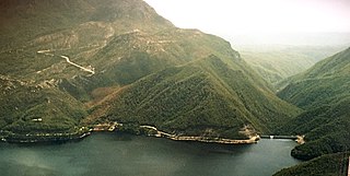
The Crotty Dam, also known during construction as the King Dam, or the King River Dam on initial approval, is a rockfill embankment dam with a controlled and uncontrolled spillway across the King River, between Mount Jukes and Mount Huxley, located in Western Tasmania, Australia.
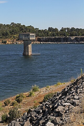
Windamere Dam is a minor ungated rock fill with clay core embankment dam with an uncontrolled unlined rock cutting spillway across the Cudgegong River at Cudgegong, upstream of Mudgee in the Central Tablelands of New South Wales, Australia. The dam's purpose includes hydro-power, irrigation, water supply, and conservation. The impounded reservoir is called Lake Windamere.

The Blowering Dam is a major ungated rock fill with clay core embankment dam with concrete chute spillway impounding a reservoir under the same name. It is located on the Tumut River upstream of Tumut in the Snowy Mountains region of New South Wales, Australia. Purposes for the dam include flood mitigation, hydro-power, irrigation, water supply and conservation. The dam is part of the Snowy Mountains Scheme, a vast hydroelectricity and irrigation complex constructed in south-east Australia between 1949 and 1974 and now run by Snowy Hydro.

Googong Dam is a minor ungated earth and rock fill with clay core embankment dam with concrete chute spillway plus a nearby 13 metres (43 ft) high earthfill saddle embankment across the Queanbeyan River upstream of Queanbeyan in the Capital Country region of New South Wales, Australia. The dam's purpose includes water supply for Canberra and Queanbeyan. The impounded reservoir is called Googong Reservoir.

The Maroon Dam is a rock and earth-fill embankment dam with an un-gated spillway across the Burnett Creek that is located in the South East region of Queensland, Australia. The main purpose of the dam is for irrigation of the Scenic Rim Regional Council region. The impounded reservoir is also called Maroon Dam.
Cochrane Dam is a minor earthfill embankment dam with concrete spillway across Georges Creek, located in the South Coast region of New South Wales, Australia. The main purpose of the dam is to supply water for hydro-power at the downstream Brown Mountain Power Station and for irrigation purposes. The impounded reservoir is called Cochrane Lake.

Wallerawang Power Station was a thermal coal power station, located near Wallerawang, in the Central Tablelands region of New South Wales, Australia. The power station was equipped with two turbo-alternators of 500 megawatts (670,000 hp) each, supplied by CA Parsons and Company of Newcastle-upon-Tyne, England. Production commenced in May 1957.

The Darwin Dam is an offstream earthfill embankment saddle dam without a spillway, located in Western Tasmania, Australia. The impounded reservoir, also formed by Crotty Dam, is called Lake Burbury.
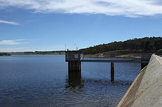
Cardinia Reservoir is an Australian man-made water supply saddle dam reservoir. The 287,000 ML water store is located in Emerald–Clematis–Dewhurst in south-eastern suburbs of Melbourne, Victoria. Construction started in May 1970 and was completed in 1973 at a cost of more than A$11.4 million. The dam that creates the impoundment is called the Cardinia Dam.
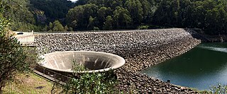
Pindari Dam is a minor concrete faced rockfill embankment dam with an ungated uncontrolled rock cut with concrete sill spillway across the Severn River located upstream of the town of Ashford, in the North West Slopes region of New South Wales, Australia. The dam's purpose includes flood mitigation, hydro-power, irrigation, water supply and conservation. The impounded reservoir is called Lake Pindari.

Talbingo Dam is a major ungated rock fill with clay core embankment dam with concrete chute spillway across the Tumut River upstream of Talbingo in the Snowy Mountains region of New South Wales, Australia. The impounded reservoir is called Talbingo Reservoir.

Clarrie Hall Dam is a minor ungated concrete faced rockfill embankment dam with an uncontrolled concrete-lined chute spillway across the Doon Doon Creek, located upstream of the small town of Uki, in the Northern Rivers region of New South Wales, Australia. The main purpose of the dam is for water supply and it creates the artificial Lake Clarrie Hall.

Toonumbar Dam is a minor ungated rock fill with clay core embankment dam with a concrete chute spillway across the Iron Pot Creek north-west of Casino in the Northern Rivers region of New South Wales, Australia. The dam's purpose includes hydro-power, irrigation, water supply, and conservation. The impounded reservoir is called Lake Toonumbar.

Duckmaloi River, a perennial stream that is part of the Macquarie catchment within the Murray–Darling basin, is located in the Central Tablelands region of New South Wales, Australia.
Grahamstown Dam is a major off-stream earthfill Embankment dam with a controlled labyrinth spillway and baffle chute that stores water from the Williams River. The dam is located north of Newcastle, New South Wales, Australia. The dam's main purpose is water supply; it provides about 40 per cent of the potable water for the Hunter Region; and is its largest drinking water supply dam.
Oberon Dam or Fish River Dam is a major ungated concrete slab and buttress with earth embankment dam comprising a concrete ski jump chute spillway and fuse plug across the Fish River upstream of Oberon in the Central Tablelands region of New South Wales, Australia. The dam's purpose includes flood mitigation, industrial, and water supply. The impounded reservoir is called Lake Oberon.
Deep Creek Dam is a major ungated concrete gravity dam across the Deep Creek in the Snowy Mountains of New South Wales, Australia. The dam's main purpose is for the diversion of water for generation of hydro-power and is the smallest of the sixteen major dams that comprise the Snowy Mountains Scheme, a vast hydroelectricity and irrigation complex constructed in south-east Australia between 1949 and 1974 and now run by Snowy Hydro.
Geehi Dam is a major ungated rockfill embankment dam across the Geehi River in the Snowy Mountains of New South Wales, Australia. The reservoir impounded by the dam is known as Geehi Reservoir.

Khancoban Dam is a major ungated earthfill embankment dam with a controlled spillway across the Swampy Plain River in the Snowy Mountains region of New South Wales, Australia. The dam's main purpose is for the generation of hydro-power and is one of the sixteen major dams that comprise the Snowy Mountains Scheme, a vast hydroelectricity and irrigation complex constructed in south-east Australia between 1949 and 1974 and now run by Snowy Hydro.
Brogo Dam is a minor ungated rockfill embankment dam with an uncontrolled unlined rock cut spillway across the Brogo River upstream of Brogo in the South Coast region of New South Wales, Australia. The dam's purpose includes environmental flows, hydro-electric power generation, irrigation, and water supply. The impounded reservoir is also called Brogo Dam.
