
The Eildon Dam is a rock and earth-fill embankment dam with a controlled spillway across the Goulburn River, is located between the regional towns of Mansfield and Eildon within Lake Eildon National Park, in the Alpine region of Victoria, Australia. The dam's purpose is for the supply of potable water, irrigation, and the generation of hydroelectricity. The impounded reservoir is called Lake Eildon.
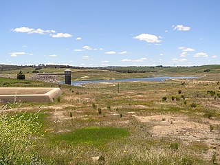
The Pejar Dam is an earth and rock-filled embankment dam with an uncontrolled spillway across the Wollondilly River, located in the Southern Tablelands region of New South Wales, Australia. The principal purpose of the dam is to supply potable water for the city of Goulburn. The impounded 9,000-megalitre reservoir is also called Pejar Dam.
The Shoalhaven Scheme is a dual-purpose water supply and Pumped-storage Hydroelectricity scheme located on the South Coast region of New South Wales, Australia.
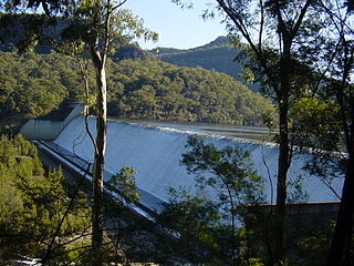
Tallowa Dam, completed in 1976, is a concrete gravity dam with central overflow spillway, located on the Shoalhaven River, downstream from the river's confluence with the Kangaroo River. The dam wall of 325 cubic metres (11,500 cu ft) is 43 metres (141 ft) high and 528 metres (1,732 ft) in length. At 100% capacity, the dam wall holds back approximately 85,500 megalitres and creates the impounded reservoir of Lake Yarrunga that has a surface area of 831 hectares, drawn from a catchment area of 5,750 square kilometres (2,220 sq mi). The spillway has a discharge capacity of 27,600 cubic metres per second (970,000 cu ft/s).
Cochrane Dam is a minor earthfill embankment dam with concrete spillway across Georges Creek, located in the South Coast region of New South Wales, Australia. The main purpose of the dam is to supply water for hydro-power at the downstream Brown Mountain Power Station and for irrigation purposes. The impounded reservoir is called Cochrane Lake.
Mangrove Creek Dam, a concrete faced rockfill embankment dam, is the primary reservoir for water supply to residents of the Central Coast in New South Wales, Australia.

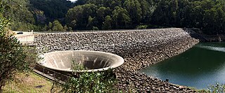
Split Rock Dam is a minor ungated concrete faced rock fill embankment dam with concrete chute spillway across the Manilla River upstream of Manilla in the north-western slopes region of New South Wales, Australia. The dam's purpose includes flood mitigation, irrigation, water supply and conservation. The impounded reservoir is called Split Rock Reservoir.

Talbingo Dam is a major ungated rock fill with clay core embankment dam with concrete chute spillway across the Tumut River upstream of Talbingo in the Snowy Mountains region of New South Wales, Australia. The impounded reservoir is called Talbingo Reservoir.
Tumut Pond Dam is a major gated concrete arch dam across the upper reaches of the Tumut River in the Snowy Mountains of New South Wales, Australia. The dam's main purpose is for the generation of hydro-power and is one of the sixteen major dams that comprise the Snowy Mountains Scheme, a vast hydroelectricity and irrigation complex constructed in south-east Australia between 1949 and 1974 and now run by Snowy Hydro.

Jounama Dam is a major ungated rockfill embankment dam across the Tumut River in the Snowy Mountains of New South Wales, Australia. The dam's main purpose is for the generation of hydro-power and is one of the sixteen major dams that comprise the Snowy Mountains Scheme, a vast hydroelectricity and irrigation complex constructed in south-east Australia between 1949 and 1974 and now run by Snowy Hydro.
Oberon Dam or Fish River Dam is a major ungated concrete slab and buttress with earth embankment dam comprising a concrete ski jump chute spillway and fuse plug across the Fish River upstream of Oberon in the Central Tablelands region of New South Wales, Australia. The dam's purpose includes flood mitigation, industrial, and water supply. The impounded reservoir is called Lake Oberon.
Rydal Dam is a minor ungated homogeneous earthfill embankment dam with a fuse plug uncontrolled open channel spillway across an off stream storage, located near Rydal in the Central Tablelands region of New South Wales, Australia. The dam's purpose is to provide water storage for Delta power stations at Wallerawang and Mount Piper. The impounded reservoir is also called the Rydal Dam.
Tumut Two Dam or Tumut Two is a major ungated concrete gravity dam across the upper reaches of the Tumut River in the Snowy Mountains of New South Wales, Australia. The dam's main purpose is for the generation of hydro-power and is one of the sixteen major dams that comprise the Snowy Mountains Scheme, a vast hydroelectricity and irrigation complex constructed in south-east Australia between 1949 and 1974 and now run by Snowy Hydro.
Geehi Dam is a major ungated rockfill embankment dam across the Geehi River in the Snowy Mountains of New South Wales, Australia. The reservoir impounded by the dam is known as Geehi Reservoir.
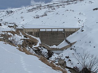
Guthega Dam is concrete gravity dam with an uncontrolled spillway across the Snowy River in the Snowy Mountains of New South Wales, Australia. The dam's main purpose is for the storage of water used in the generation of hydro-power. It is the first to be completed of the sixteen major dams of the Snowy Mountains Scheme, a vast hydroelectricity and irrigation complex constructed in south-east Australia between 1949 and 1974 and now run by Snowy Hydro.
Island Bend Dam is a major gated concrete gravity dam with a controlled spillway across the Snowy River in the Snowy Mountains region of New South Wales, Australia. The dam's main purpose is for the diversion of water for generation of hydro-power and is one of the sixteen major dams that comprise the Snowy Mountains Scheme, a vast hydroelectricity and irrigation complex constructed in south-east Australia between 1949 and 1974 and now run by Snowy Hydro.
Murray Two Dam or Murray 2 Dam is a major ungated concrete arch dam with a controlled spillway across Khancoban Bank, a diverted flow of the Snowy and Geehi rivers in the Snowy Mountains region of New South Wales, Australia. The impounded reservoir is called the Murray Two Pondage or Murray 2 Pondage.
Yellow Pinch Dam is a major off-stream ungated rockfill embankment dam across the Yellow Pinch Creek upstream of Merimbula in the South Coast region of New South Wales, Australia. The dam's main purpose is water supply. The impounded reservoir is also called Yellow Pinch Dam.

Fitzroy Falls Dam, located in New South Wales, Australia, is part of the Shoalhaven Scheme, a complex of dams and pipelines that was completed in 1974. It consists of four separate earth and rockfill embankments located on the Yarrunga Creek upstream of Fitzroy Falls and about 16 kilometres (9.9 mi) southeast of Moss Vale. The main embankment of 760 cubic metres (27,000 cu ft) is 14 metres (46 ft) high and 1,530 metres (5,020 ft) in length. At 100% capacity, the dam wall holds back approximately 9,950 megalitres of water, creating the impounded Fitzroy Falls Reservoir, which has a surface area of 522 hectares, drawn from a catchment area of 31 square kilometres (12 sq mi). The spillway has a discharge capacity of 516 cubic metres per second (18,200 cu ft/s).

Wingecarribee Dam, completed in 1974 as part of the Shoalhaven Scheme, is an earth and rockfill embankment dam structure located on the Wingecarribee River about 15 kilometres (9.3 mi) southeast of Bowral in New South Wales, Australia. The embankment of 573 cubic metres (20,200 cu ft) is 19 metres (62 ft) high and 1,140 metres (3,740 ft) in length. At 100% capacity, the dam wall holds back approximately 25,875 megalitres and creates the impounded reservoir of Wingecarribee Reservoir that has a surface area of 625 hectares, drawn from a catchment area of 40 square kilometres (15 sq mi). The spillway has a discharge capacity of 520 cubic metres per second (18,000 cu ft/s). Wingecarribee Reservoir lost around 9,000 megalitres of storage capacity as a result of the inflow of peat from the Wingecarribee Swamp collapse in August 1998. The original storage capacity was 34,500 megalitres.
