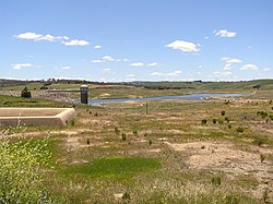
Hume Dam, formerly the Hume Weir, is a major dam across the Murray River downstream of its junction with the Mitta River in the Riverina region of New South Wales, Australia. The dam's purpose includes flood mitigation, hydro-power, irrigation, water supply and conservation. The impounded reservoir is called Lake Hume, formerly the Hume Reservoir. It is a gated concrete gravity dam with four earth embankments and twenty-nine vertical undershot gated concrete overflow spillways.

Goulburn is a regional city in the Southern Tablelands of the Australian state of New South Wales, approximately 195 kilometres (121 mi) south-west of Sydney, and 90 kilometres (56 mi) north-east of Canberra. It was proclaimed as Australia's first inland city through letters patent by Queen Victoria in 1863. Goulburn had a population of 23,835 at June 2018. Goulburn is the seat of Goulburn Mulwaree Council.

The Eildon Dam or Eildon Weir, a rock and earth-fill embankment dam with a controlled spillway across the Goulburn River, is located between the regional towns of Mansfield and Eildon within Lake Eildon National Park, in the Alpine region of Victoria, Australia. The dam's purpose is for the supply of potable water, irrigation, and the generation of hydroelectricity. The impounded reservoir is called Lake Eildon.

The Waranga Dam is a major earthfill embankment dam with an uncontrolled spillway located approximately 150 kilometres (93 mi) north of Melbourne in the North Central region of the Australian state of Victoria. The impounded off-stream reservoir is Waranga Basin and forms part of the Goulburn River irrigation system, irrigating an area of 626 square kilometres (242 sq mi). The dam and reservoir are located in Shire of Campaspe near the City of Greater Shepparton and is located 8 kilometres (5.0 mi) northeast of Rushworth, 12 kilometres (7.5 mi) southwest of Tatura, and near Murchison. When full, the reservoir covers an area of 58.5 square kilometres (22.6 sq mi).

Lake Eppalock is an Australian reservoir in North Central Victoria about 130 kilometres (81 mi) northwest of Melbourne. It was formed by the construction of a major earth and rockfill embankment dam, known as Eppalock Dam, with a controlled chute spillway across the Campaspe and the Coliban rivers. The lake is situated between the regional population centres of Bendigo and Heathcote and serves as a major water storage facility for both places, as well as the Campaspe irrigation district. The lake also serves as a popular sports and recreational facility.

The Stephens Creek Dam is an earth-filled embankment dam built on a rock foundation with an uncontrolled spillway across the Stephens Creek, located in the Far West region of New South Wales, Australia. The principal purpose of the dam is to supply potable water for the town of Broken Hill. The impounded 2,000-megalitre reservoir is called Stephens Creek Reservoir.

The Queanbeyan River, a perennial stream that is part of the Molonglo catchment within the Murray–Darling basin, is located in the Monaro and Capital Country regions of New South Wales and the Australian Capital Territory, in Australia. The river is 104 kilometres (65 mi) in length with a catchment area of 96,000 hectares. The Queanbeyan River and the Cotter River meet the potable water supply needs of the Canberra and Queanbeyan region and whose water quality is specifically protected under Federal legislation.

Lostock Dam is a minor rockfill and clay core embankment dam with a concrete lined, flip bucket spillway across the Paterson River upstream of the village of East Gresford in the Hunter region of New South Wales, Australia. The dam's purpose includes flood mitigation, irrigation, water supply and conservation. Mini hydro-power facilities were retrofitted in 2010. The impounded reservoir is also called Lostock Dam.

The Maroon Dam is a rock and earth-fill embankment dam with an un-gated spillway across the Burnett Creek that is located in the South East region of Queensland, Australia. The main purpose of the dam is for irrigation of the Scenic Rim Regional Council region. The impounded reservoir is also called Maroon Dam.
Cochrane Dam is a minor earthfill embankment dam with concrete spillway across Georges Creek, located in the South Coast region of New South Wales, Australia. The main purpose of the dam is to supply water for hydro-power at the downstream Brown Mountain Power Station and for irrigation purposes. The impounded reservoir is called Cochrane Lake.
Mangrove Creek Dam, a concrete faced rockfill embankment dam, is the primary reservoir for water supply to residents of the Central Coast in New South Wales, Australia.
The William Hovell Dam is a rock and earth-fill embankment dam with a flip bucket chute spillway across the King River, located in the Hume region of Victoria, Australia. The purposes of the dam are for irrigation and the generation of hydroelectricity. The impounded reservoir is called Lake William Hovell

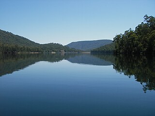
The Ross River Dam is a rock and earthfill-filled embankment dam across the Ross River, located between Kelso and Mount Stuart in the City of Townsville in northern Queensland, Australia. Built initially for flood control, Lake Ross, the impoundment created by the dam, serves as one of the major potable water supplies for the region.
The Nillahcootie Dam, a rock and earth-fill embankment dam with a unique Gothic arch-shaped crest spillway across the Broken River that is located near Mansfield, in the Alpine region of Victoria, Australia. The dam's purpose is for the supply of potable water and for irrigation. The impounded reservoir is called Lake Nillahcootie.
Gosling Creek Dam is a decommissioned minor earth and rock fill with clay core embankment dam with concrete chute spillway across the Gosling Creek upstream of Orange in the central western region of New South Wales, Australia. Commissioned in 1890 to supply Orange with potable water, the dam was decommissioned after the official commissioning of the Suma Park Dam in 1962. The impounded reservoir is called Gosling Creek Reservoir and is now used for recreation purposes.

The Cooby Dam is a rock–fill embankment dam with an un–gated spillway across the Cooby Creek, a tributary of Condamine River, at Groomsville in the Darling Downs region of Queensland, Australia. The main purpose of the dam is for potable water supply of the Toowoomba region. The impounded reservoir is called the Cooby Creek Reservoir.

Lake Julius was formed following the construction of Julius Dam in 1976 for irrigation and town water storage. The dam wall is located just below the junction of the Leichhardt River and Paroo Creek some 70 kilometres (43 mi) North East of Mount Isa. It has a full supply capacity of 127,000 megalitres, a surface area of 1,255 hectares with an average depth of 8.9 metres (29 ft).

The Wyaralong Dam is a mass concrete gravity dam with an un-gated spillway across the Teviot Brook that is located in the South East region of Queensland, Australia. The main purpose of the dam is for supply of potable water for the Scenic Rim region. The impounded reservoir is also called Wyaralong Dam. The dam was initiated by the Queensland Government in 2006 as a result of a prolonged drought which saw the catchment areas of South East Queensland's dams receive record low rain.
Grahamstown Dam is a major off-stream earthfill Embankment dam with a controlled labyrinth spillway and baffle chute that stores water from the Williams River. The dam is located north of Newcastle and within the Port Stephens Council local government area in the Lower Hunter Region of New South Wales, Australia. The dam's main purpose is water supply; it provides about 40 per cent of the potable water for the Hunter region; and is the Hunter's largest drinking water supply dam.
Rydal Dam is a minor ungated homogeneous earthfill embankment dam with a fuse plug uncontrolled open channel spillway across an off stream storage, located near Rydal in the Central Tablelands region of New South Wales, Australia. The dam's purpose is to provide water storage for Delta power stations at Wallerawang and Mount Piper. The impounded reservoir is also called the Rydal Dam.