Eucumbene Dam

Last updated

Eucumbene Dam
Lake Eucumbene in April 2012.JPG
Lake Eucumbene looking towards the Snowy Mountains, 2012.
Australia New South Wales location map blank.svg
Red pog.svg
Location of Eucumbene Dam in
New South Wales
CountryAustralia
Location Snowy Mountains, New South Wales
Coordinates 36°07′42″S148°36′57″E / 36.12843°S 148.61575°E / -36.12843; 148.61575
Purpose Hydro-power, diversion, irrigation
StatusOperational
Construction beganMay 1956 (1956-05)
Opening dateMay 1958 (1958-05)
Owner(s) Snowy Hydro
Dam and spillways
Type of dam Embankment dam
Impounds Eucumbene River
Height116 m (381 ft)
Length579 m (1,900 ft)
Elevation at crest1,168 metres (3,832 ft) AHD
Width (base)686 m (2,251 ft)
Dam volume6,735,000 m3 (237,800,000 cu ft)
Spillways 1
Spillway type Overflow ski-jump and bucket with two vertical lift gates
Spillway capacity475 m3/s (16,800 cu ft/s)
Reservoir
CreatesLake Eucumbene
Total capacity4,798 GL (1.055×10¹² imp gal; 1.267×10¹² US gal)
(4.798  km3; 3,890,000  acre⋅ft)
Active capacity4,366.5 GL (9.605×10¹¹ imp gal; 1.1535×10¹² US gal)
(4.3665  km3; 3,540,000  acre⋅ft)
Catchment area 683 km2 (264 sq mi)
Surface area14,542 ha (35,930 acres)
Maximum water depth107 m (351 ft)
Website
Eucumbene Dam at the Powerhouse Museum.

Eucumbene Dam is a major gated earthfill embankment dam with an overflow ski-jump and bucket spillway with two vertical lift gates across the Eucumbene River in the Snowy Mountains of New South Wales, Australia. The dam's main purpose is for the generation of hydro-power and is one of the sixteen major dams that comprise the Snowy Mountains Scheme, a vast hydroelectricity and irrigation complex constructed in south-east Australia between 1949 and 1974 and now run by Snowy Hydro.

Contents

The impounded reservoir is called Lake Eucumbene, the largest storage lake in the Snowy Mountains Scheme.

Location and features

Commenced in May 1956 and completed in May 1958, Eucumbene Dam is a major dam, located approximately 1 kilometre (0.62 mi) northeast of the locality of Eucumbene Cove. The dam was constructed by a consortium comprising the Department of Public Works and Kaiser-Walsh-Perini-Raymond based on engineering plans developed by the United States Bureau of Reclamation and the Department of Public Works, under contract from the Snowy Mountains Hydroelectric Authority. [1] Construction of the dam inundated the original township of Old Adaminaby, which was relocated to Adaminaby in the 1950s, requiring approximately 800 people to be moved. [1]

The outer walls of the dam are built of rock while the inner core is compacted, impervious clay. The earthfill embankment dam wall comprising 6,735,000 cubic metres (237,800,000 cu ft) of earth and rockfill is 116 metres (381 ft) high and 579 metres (1,900 ft) long. The foundation of the dam comprises closely jointed hard siltstone and quartzite with overburden of decomposed rock and slope-wash up to 6.1 metres (20 ft) deep. A subsidiary embankment containing 121,900 cubic metres (4,300,000 cu ft) of fill across a low saddle in a ridge forms the left abutment of the dam wall. At 100% capacity the dam wall, with an elevation of 1,168 metres (3,832 ft) AHD, holds back 4,798 gigalitres (1.055×10¹² imp gal; 1.267×10¹² US gal) or (4.798  km3 ; 3,890,000  acre⋅ft) of water, approximately equal to nine times the volume of Sydney Harbour. The surface area of Lake Eucumbene is 14,542 hectares (35,930 acres) and the catchment area is 683 square kilometres (264 sq mi). The overflow ski-jump and bucket spillway with two vertical lift gates is capable of discharging 475 cubic metres per second (16,800 cu ft/s). The two gates, each 6.7 metres (22 ft) wide by 3.9 metres (13 ft) high were constructed during 1977-78 under a separate contract. [1] [2] [3] [4]

Lake Eucumbene

Lake Eucumbene is the largest reservoir in the Snowy Mountains Scheme and is the central connection for the northern (Tumut/Murrumbidgee rivers) and southern (Snowy River) halves of the Scheme. The Goodradigbee and Murrumbidgee rivers from Tantangara Dam are connected to the Eucumbene River at Lake Eucumbene via the Murrumbidgee-Eucumbene Haupt-tunnel. The Eucumbene River at Lake Eucumbene is connected to the Snowy River at Island Bend Pondage via the 23.5 kilometres (14.6 mi) long Eucumbene-Snowy Haupt-tunnel; the longest tunnel in the Snowy Mountains Scheme, with a circular diameter of 6.3 metres (21 ft). [4]

Also at Lake Eucumbene, the 22.2 kilometres (13.8 mi) long Eucumbene-Tumut Haupt-tunnel diverts the flow of the Snowy River to the Tumut River, empting into Tumut Pond Reservoir; and into the Murray–Darling basin. This tunnel was constructed between November 1954 and July 1959 and along 28% of its length is lined with a 6.4 metres (21 ft) circular diameter. The residual length of the tunnel in unlined and 6.93 metres (22.7 ft) circular in diameter. Construction was through granite and metamorphosed sedimentary rock, involving the excavation of 978,600 cubic metres (34,560,000 cu ft); and 71,100 cubic metres (2,510,000 cu ft) concrete was used to install the pipeline. [4]

Lake Eucumbene.jpg
Lake Eucumbene, 2006

The valley, which was flooded following construction of the Eucumbene Dam, had been an agricultural centre since the 1830s. A number of homesteads and most of the township of Adaminaby lay within the inundation area of the proposed dam. Most of the buildings in the town relocated to a site on the Snowy Mountains Highway, but some buildings were not flooded and remain at Old Adaminaby.

The story of Adaminaby's relocation was the subject of film produced by the Snowy Mountains Authority Film Unit in 1958, entitled Operation Adaminaby. It was also the subject of a 2001 documentary by historian Jeannine Baker, entitled Our Drowned Town, which screened on SBS Television. Entire houses, and even the Commercial Bank building were transported on the back of trucks and over 100 buildings were re-erected at the new townsite. [5] Transportation of the first house from Old Adaminaby to New Adaminaby (a distance of just six miles) took six days. [6] Today a tourist village has been built around the handful of buildings which were not relocated from the newly created lakeshore at Old Adaminaby.

When the lake is low, remains of the former township and other relics can be seen along the shoreline. For a period of time around 2007, the waters of Lake Eucumbene had receded due to a prolonged drought and Old Adaminaby began to reveal itself after being underwater for over 50 years – gaining the attention of the global media. [7] Of particular interest was the re-emergence of the old 6 Mile Bridge near Anglers Reach on the former highway route to Kiandra.

Climate

Lake Eucumbene has mild, stormy summers and cold, wet winters; with a largely uniform rainfall pattern, peaking somewhat in late winter and springtime. Frosts occur regularly during autumn, winter and spring, and can occur also in summer. Snowfall can occur at any time of the year, save for high summer.

Climate data for Adaminaby (Yaouk, 1969–2022); 1,140 m AMSL; 35.79° S, 148.81° E
MonthJanFebMarAprMayJunJulAugSepOctNovDecYear
Average precipitation mm (inches)79.0
(3.11)
73.8
(2.91)
59.1
(2.33)
50.2
(1.98)
57.8
(2.28)
81.8
(3.22)
71.1
(2.80)
90.8
(3.57)
87.4
(3.44)
73.7
(2.90)
86.3
(3.40)
81.7
(3.22)
909.9
(35.82)
Source: Australian Bureau of Meteorology; Adaminaby (Yaouk)

See also

Related Research Articles

<span class="mw-page-title-main">Snowy Mountains</span> Mountain range in Australia

The Snowy Mountains, known informally as "The Snowies", is an IBRA subregion in southern New South Wales, Australia, and is the tallest mountain range in mainland Australia, being part of the continent's Great Dividing Range cordillera system. It makes up the northeastern half of the Australian Alps and contains Australia's five tallest peaks, all of which are above 2,100 m (6,890 ft), including the tallest Mount Kosciuszko, which reaches to a height of 2,228 m (7,310 ft) above sea level. The offshore Tasmanian highlands makes up the only other major alpine region present in the whole of Australia.

<span class="mw-page-title-main">Snowy Mountains Scheme</span> Dam in Kosciuszko National Park, New South Wales

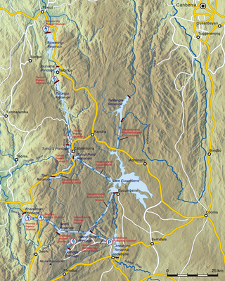
The Snowy Mountains Scheme, also known as the Snowy Hydro or the Snowy scheme, is a hydroelectricity and irrigation complex in south-east Australia. Near the border of New South Wales and Victoria, the scheme consists of sixteen major dams; nine power stations; two pumping stations; and 225 kilometres (140 mi) of tunnels, pipelines and aqueducts that were constructed between 1949 and 1974. The Scheme was completed under the supervision of Chief Engineer, Sir William Hudson. It is the largest engineering project undertaken in Australia.

<span class="mw-page-title-main">Eucumbene River</span> River in New South Wales, Australia

The Eucumbene River, a perennial river of the Snowy River catchment, is located in the Snowy Mountains region of New South Wales, Australia.

<span class="mw-page-title-main">Adaminaby</span> Town in New South Wales, Australia

Adaminaby is a small town near the Snowy Mountains north-west of Cooma, New South Wales, Australia, in the Snowy Monaro Regional Council. The historic town, of 301 people at the 2016 census, is a trout fishing centre and winter sports destination situated at 1,017 metres (3,337 ft) above sea level. Economic life is built around tourism and agriculture–the town serves as a service point for Selwyn Snowfields and the Northern Skifields. It is also a popular destination for horse riders, bushwalkers, fly-fishermen and water sports enthusiasts as well as a base for viewing aspects of the Snowy Mountains Scheme.

<span class="mw-page-title-main">Blowering Dam</span> Dam in Snowy Mountains, New South Wales

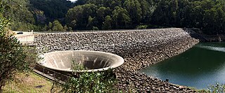
The Blowering Dam is a major ungated rock fill with clay core embankment dam with concrete chute spillway impounding a reservoir under the same name. It is located on the Tumut River upstream of Tumut in the Snowy Mountains region of New South Wales, Australia. Purposes for the dam include flood mitigation, hydro-power, irrigation, water supply and conservation. The dam is part of the Snowy Mountains Scheme, a vast hydroelectricity and irrigation complex constructed in south-east Australia between 1949 and 1974 and now run by Snowy Hydro.

<span class="mw-page-title-main">Jindabyne Dam</span> Dam in Snowy Mountains, New South Wales

Jindabyne Dam is a major ungated rockfill embankment dam across the Snowy River in the Snowy Mountains of New South Wales, Australia. The dam's main purpose is to redirect water from the Snowy River to the Murray, for the generation of hydro-power and irrigation. It is one of the sixteen major dams that comprise the Snowy Mountains Scheme, a vast hydroelectricity and irrigation complex constructed in south-east Australia between 1949 and 1974 and now run by Snowy Hydro.

<span class="mw-page-title-main">Tooma Dam</span> Dam in Snowy Mountains, New South Wales

Tooma Dam is a major ungated earthen embankment dam across the Tooma River in the Snowy Mountains of New South Wales, Australia. The dam's main purpose is for the generation of hydro-power and is one of the sixteen major dams that comprise the Snowy Mountains Scheme, a vast hydroelectricity and irrigation complex constructed in south-east Australia between 1949 and 1974 and now run by Snowy Hydro.

<span class="mw-page-title-main">Tantangara Dam</span> Dam in Snowy Mountains, New South Wales

Tantangara Dam is a major ungated concrete gravity dam with concrete chute spillway across the Murrumbidgee River in Tantangara, upstream of Adaminaby in the Snowy Mountains region of New South Wales, Australia. The dam is part of the Snowy Mountains Scheme, a vast hydroelectricity and irrigation complex constructed in south-east Australia between 1949 and 1974 and now run by Snowy Hydro. The purpose of the dam includes water management and conservation, with much of the impounded headwaters diverted to Lake Eucumbene. The impounded reservoir is called Tantangara Reservoir.

<span class="mw-page-title-main">Talbingo Dam</span> Dam in Snowy Mountains, New South Wales

Talbingo Dam is a major ungated rock fill with clay core embankment dam with concrete chute spillway across the Tumut River upstream of Talbingo in the Snowy Mountains region of New South Wales, Australia. The impounded reservoir is called Talbingo Reservoir.

<span class="mw-page-title-main">Tumut River</span> River in Australia

The Tumut River, a perennial stream that is part of the Murrumbidgee catchment within the Murray–Darling basin, is located in the Snowy Mountains and South West Slopes districts of New South Wales, Australia.

<span class="mw-page-title-main">Tumut Pond Dam</span> Dam in Snowy Mountains, New South Wales

Tumut Pond Dam is a major gated concrete arch dam across the upper reaches of the Tumut River in the Snowy Mountains of New South Wales, Australia. The dam's main purpose is for the generation of hydro-power and is one of the sixteen major dams that comprise the Snowy Mountains Scheme, a vast hydroelectricity and irrigation complex constructed in south-east Australia between 1949 and 1974 and now run by Snowy Hydro.

<span class="mw-page-title-main">Jounama Dam</span> Dam in Snowy Mountains, New South Wales

Jounama Dam is a major ungated rockfill embankment dam across the Tumut River in the Snowy Mountains of New South Wales, Australia. The dam's main purpose is for the generation of hydro-power and is one of the sixteen major dams that comprise the Snowy Mountains Scheme, a vast hydroelectricity and irrigation complex constructed in south-east Australia between 1949 and 1974 and now run by Snowy Hydro.

Tumut Two Dam or Tumut Two is a major ungated concrete gravity dam across the upper reaches of the Tumut River in the Snowy Mountains of New South Wales, Australia. The dam's main purpose is for the generation of hydro-power and is one of the sixteen major dams that comprise the Snowy Mountains Scheme, a vast hydroelectricity and irrigation complex constructed in south-east Australia between 1949 and 1974 and now run by Snowy Hydro.

Deep Creek Dam is a major ungated concrete gravity dam across the Deep Creek in the Snowy Mountains of New South Wales, Australia. The dam's main purpose is for the diversion of water for generation of hydro-power and is the smallest of the sixteen major dams that comprise the Snowy Mountains Scheme, a vast hydroelectricity and irrigation complex constructed in south-east Australia between 1949 and 1974 and now run by Snowy Hydro.

<span class="mw-page-title-main">Geehi Dam</span> Dam in Snowy Mountains, New South Wales

Geehi Dam is a major ungated rockfill embankment dam across the Geehi River in the Snowy Mountains of New South Wales, Australia. The reservoir impounded by the dam is known as Geehi Reservoir.

Happy Jacks Dam is a major ungated concrete gravity dam across the Tumut River in the Snowy Mountains region of New South Wales, Australia. The dam's main purpose is for the generation of hydro-power and is one of the sixteen major dams that comprise the Snowy Mountains Scheme, a vast hydroelectricity and irrigation complex constructed in south-east Australia between 1949 and 1974 and now run by Snowy Hydro.

Island Bend Dam is a major gated concrete gravity dam with a controlled spillway across the Snowy River in the Snowy Mountains region of New South Wales, Australia. The dam's main purpose is for the diversion of water for generation of hydro-power and is one of the sixteen major dams that comprise the Snowy Mountains Scheme, a vast hydroelectricity and irrigation complex constructed in south-east Australia between 1949 and 1974 and now run by Snowy Hydro.

Khancoban Dam is a major ungated earthfill embankment dam with a controlled spillway across the Swampy Plain River in the Snowy Mountains region of New South Wales, Australia. The dam's main purpose is for the generation of hydro-power and is one of the sixteen major dams that comprise the Snowy Mountains Scheme, a vast hydroelectricity and irrigation complex constructed in south-east Australia between 1949 and 1974 and now run by Snowy Hydro.

Murray Two Dam or Murray 2 Dam is a major ungated concrete arch dam with a controlled spillway across Khancoban Bank, a diverted flow of the Snowy and Geehi rivers in the Snowy Mountains region of New South Wales, Australia. The impounded reservoir is called the Murray Two Pondage or Murray 2 Pondage.

<span class="mw-page-title-main">Old Adaminaby and Lake Eucumbene</span> Historic site in New South Wales, Australia

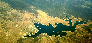
Old Adaminaby and Lake Eucumbene are the heritage-listed former town of Adaminaby and the reservoir that flooded the town, now at Eucumbene, Snowy Valleys Council, New South Wales, Australia. The town was established in 1830. The reservoir was designed by the Snowy Hydro Electric Authority and built from 1956 to 1958 by the Authority. It is also known as Old Adaminaby and Lake Eucumbene, including relics and movable objects, Eucumbene River, Eucumbene Valley, Old Adaminaby Remains, Old Adaminaby Ruins and Old Adaminaby Drowned Landscape. The property is owned by Snowy Hydro Limited, a statutory corporation owned by the governments of Australia, New South Wales and Victoria. The site was added to the New South Wales State Heritage Register on 3 June 2008.

References

  1. 1 2 3 "Register of Large Dams in Australia". Dams information. The Australian National Committee on Large Dams Incorporated. 2010. Archived from the original (Excel (requires download)) on 12 December 2013. Retrieved 10 May 2013.
  2. "Dams". Snowy Mountains Scheme. Snowy Hydro. Archived from the original on 3 May 2013. Retrieved 10 May 2013.
  3. "Section through Eucumbene Dam". Snowy! power of a nation. Powerhouse Museum. 1993. Archived from the original on 20 October 2012. Retrieved 11 May 2013.
  4. 1 2 3 "Civil structures". Snowy! power of a nation. Powerhouse Museum. 1993. Archived from the original on 3 March 2016. Retrieved 11 May 2013.
  5. "Adaminaby". Snowy Mountains Towns. Tourism Snowy Mountains. 2012. Retrieved 11 May 2013.
  6. "Operation Adaminaby" (Film clips). Snowy Hydro. National Film and Sound Archive. 1958. Retrieved 11 May 2013.
  7. Squires, Nick (5 June 2007). "Flooded town re-emerges after 50 years". The Telegraph. London. Archived from the original on 20 February 2009. Retrieved 20 June 2012.