
Cooma is a town in the south of New South Wales, Australia. It is located 114 kilometres (71 mi) south of the national capital, Canberra, via the Monaro Highway. It is also on the Snowy Mountains Highway, connecting Bega with the Riverina.

Rosewood is a village community and locality in the south east part of the Riverina, New South Wales, Australia. It is situated about 16 kilometres (9.9 mi) south east from Carabost and 19 kilometres (12 mi) north west from Tumbarumba. At the 2016 census, Rosewood had a population of 214. The village is administered by two local governments; the northern part of the locality by the Greater Hume Shire and the southern part of the locality by the Snowy Valleys Council. The village of Rosewood is within the Snowy Valleys Council area.

The Snowy Monaro Regional Council is a local government area located in the Snowy Mountains and Monaro regions of New South Wales, Australia. The council was formed on 12 May 2016 through a merger of the Bombala, Cooma-Monaro and Snowy River shires.

Colinton is a locality in the Snowy Monaro Region, New South Wales, Australia. It lies on the eastern side of the Murrumbidgee River and on both sides of the Monaro Highway about 73 km south of Canberra and about 44 km north of Cooma. At the 2016 census, it had a population of 127.

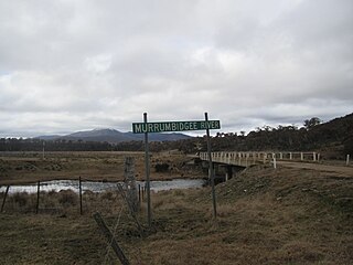
Billilingra is a locality in the Snowy Monaro Region, New South Wales, Australia. It lies on both sides of the Murrumbidgee River and on both sides of the Monaro Highway about 91 km south of Canberra and about 26 km north of Cooma. At the 2016 census, it had a population of 13.

Chakola is a locality in the Snowy Monaro Region, New South Wales, Australia. It lies on both sides of the Murrumbidgee River and both sides of the Numeralla River. It also lies on both sides of the Monaro Highway about 100 km south of Canberra and about 25 km north of Cooma. At the 2016 census, it had a population of 47.

Bunyan is a locality in the Snowy Monaro Region, New South Wales, Australia. It lies on the eastern side of the Murrumbidgee River and on both sides of the Monaro Highway about 110 km south of Canberra and about 10 km north of Cooma. At the 2016 census, it had a population of 152.

Ballalaba is a locality in the Queanbeyan–Palerang Regional Council, New South Wales, Australia. It is located about 30 km southwest of Braidwood on the road to Cooma and on the Shoalhaven River. At the 2016 census, it had a population of 22. It had a "half-time" school from 1867 to 1870; from 1879 to 1940, it operated either as a "provisional" or a "half-time" school".

Northangera is a locality in the Queanbeyan-Palerang Region, Southern Tablelands, New South Wales, Australia. The name Northangera was assigned on 13 July 2001. It lies on the Kings Highway about 100 km east of Canberra and 15 km east of Braidwood. At the 2016 census, it had a population of 43. It had a "half-time" School from 1921 to 1931.

Richlands is a locality in the Upper Lachlan Shire, New South Wales, Australia. It lies about 5 km north of Taralga and about 95 km south of Oberon on the road from Goulburn to Oberon and Bathurst. At the 2016 census, it had a population of 34. It had a school from June 1868 to August 1879, which was designated as a "provisional school" for eight months and then as a "half-time" school. It also had a school from 1884 to 1915 and from 1918 to 1953, classified most commonly as a "provisional school", but for periods as a "house to house", "half-time" or "public" school. It was called Abercrombie school until 1894.
Yaouk is a locality in the Snowy Monaro Region, New South Wales, Australia. It lies in open grassland valleys surrounded by mountains on both sides of the Murrumbidgee River, downstream from and east of the Tantangara Dam, north of Adaminaby, east of the Kosciuszko National Park and south of the Namadgi National Park in the Australian Capital Territory, but separated from it by the mountainous Scabby Range. It is about 110 km south of Canberra and about 75 km northwest of Cooma. At the 2016 census, it had a population of 25.

Dry Plain is a locality in the Snowy Monaro Region, New South Wales, Australia. It is located in grasslands mainly to the east of the Snowy Mountains Highway, about 25 km southeast of Adaminaby and 40 km northwest of Cooma, straddling an altitude of approximately 1,260 m above mean sea level. It is about 160 km south of Canberra. At the 2016 census, it had a population of 42.

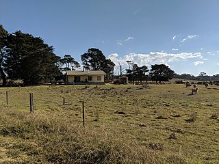
Dairymans Plains is a locality in the Snowy Monaro Region, New South Wales, Australia. It is located to the north of the Snowy Mountains Highway, to the immediate northwest of Cooma. At the 2016 census, it had a population of 152. It contains grazing country, a rural residential development, Cooma Golf Course and a large car wrecking yard.

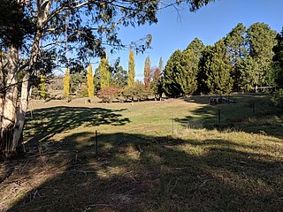
Pine Valley is a locality in the Snowy Monaro Region, New South Wales, Australia. It is located to the south of the Snowy Mountains Highway, to the immediate southwest of Cooma. At the 2016 census, it had a population of 32.

Durran Durra is a locality in the Queanbeyan–Palerang Regional Council, New South Wales, Australia. It is located on the road from Braidwood to Nowra about 15 km north of Braidwood and 100 km east of Canberra. At the 2016 census, it had a population of 107. It consists mainly of grazing country.
Marlowe is a locality in the Queanbeyan–Palerang Regional Council, New South Wales, Australia. It is located on the south side of the Mongarlowe River on the road from Braidwood to Nowra about 24 km north of Braidwood and 96 km southwest of Nowra. At the 2016 census, The Australian Bureau of Statistics recorded it as having a population of nil, although it does have at least one house. It consists mainly of forest and grazing country. Marlowe includes the "rural place" of Charleyong in a loop of the Mongarlowe River at 35°14′57″S149°55′02″E.
Tomboye is a locality in the Queanbeyan–Palerang Regional Council, New South Wales, Australia. It is located on the north side of the Mongarlowe River on the road from Braidwood to Nowra about 28 km north of Braidwood and 93 km southwest of Nowra. At the 2016 census, it had a population of 40. It consists mainly of forest and grazing country.

Corang is a locality in the Queanbeyan–Palerang Regional Council, New South Wales, Australia. It is located on the north side of the Corang River and to the east of the road from Braidwood to Nowra about 46 km north of Braidwood and 75 km southwest of Nowra. At the 2016 census, it had a population of 13. It consists mainly of forest and most of it lies in the Morton National Park. Its eastern boundary runs along the Budawang Range and includes Mount Tarn, Sturgiss Mountain and Quiltys Mountain.

Yerriyong is a locality in the City of Shoalhaven in New South Wales, Australia. It lies about 17 km to the southwest of Nowra on the road to Nerriga and Canberra. It is largely made up of eucalyptus forest. At the 2016 census, it had a population of 25.

Rhine Falls is a locality within the Snowy Monaro Regional Council, straddling between Wambrook and Dry Plain; at an altitude of 1,320 m above mean sea level, thereby ranking as one of the highest-elevated localities in Australia. Likewise, snow falls heavily and frequently from May through to September, and can fall at any time of the year. At the 2016 census, it had a population of 42, the same as neighbouring Dry Plain.

