
The Monaro Highway is a highway in Victoria, New South Wales, and the Australian Capital Territory, in Australia.

Cooma is a town in the south of New South Wales, Australia. It is located 114 kilometres (71 mi) south of the national capital, Canberra, via the Monaro Highway. It is also on the Snowy Mountains Highway, connecting Bega with the Riverina.

Bombala is a town in the Monaro region of south-eastern New South Wales, Australia, in Snowy Monaro Regional Council. It is approximately 485 kilometres (301 mi) south of the state capital, Sydney, and 80 kilometres (50 mi) south of the town of Cooma. The name derives from an Aboriginal word meaning "Meeting of the waters". The town lies on the banks of the Bombala River. At the 2016 census, Bombala had a population of 1,387.

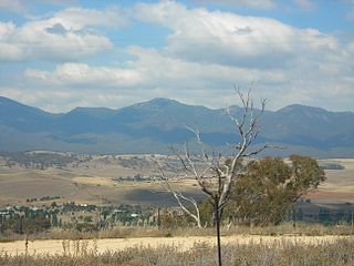
Monaro, once frequently spelled "Manaro", or in early years of settlement "Maneroo" is a region in the south of New South Wales, Australia. A small area of Victoria near Snowy River National Park is geographically part of the Monaro. While the Australian Capital Territory is not considered part of the region, some towns in the Monaro have close links with Canberra.
Michelago is a village in the Monaro region of New South Wales, Australia. The village is in the Snowy Monaro Regional Council local government area, 54 kilometres (34 mi) south of Canberra on the Monaro Highway. It was founded in the 1820s, on the main route from Sydney to the Snowy Mountains. At the 2016 census, Michelago had a population of 562.

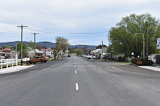
Bredbo is a village on the Monaro plains of New South Wales, Australia. The village is on the Monaro Highway 34 kilometres (21 mi) north of Cooma. The village is in the Snowy Monaro Regional Council and had a population of 352 at the 2016 census.

Monaro, also known as Maneroo (1856–58), Monara (1858-1879) and Manaro (1894-1904) is an electoral district of the Legislative Assembly in the Australian state of New South Wales. It is currently represented by Nichole Overall of the National Party.

The Snowy River Shire was a local government area in the Australian Alps region of New South Wales, Australia from 1939 until May 2016. It was named after the Snowy River that runs through it. Prior to 1936, it had been named as Dalgety Shire since establishment in 1906.
Group 16 is a rugby league competition on the south coast of New South Wales, run under the auspices of the Country Rugby League. Group 16 covers the area from Batemans Bay down to Eden.
Delegate is a small town in New South Wales, Australia in Snowy Monaro Regional Council, 523 kilometres (325 mi) south of the state capital, Sydney.

The Bombala Shire was a local government area in the Monaro region of south-eastern New South Wales, Australia. The Shire includes the town of Bombala, the villages of Delegate, Cathcart, Bibbenluke and the localities of Ando, Bungarby, Craigie, Mila, Rockton and Creewah. Bombala Shire was formed on 1 October 1977 by the amalgamation of the Municipality of Bombala and Bibbenluke Shire.
Eden-Bombala was an electoral district of the Legislative Assembly in the Australian state of New South Wales from 1894 to 1904, including the town of Eden. In 1894, single-member electorates were introduced statewide and the seat of Eden was split into Eden-Bombala and Bega. In 1904 Eden-Bombala was abolished as a result of the 1903 New South Wales referendum which reduced the number of members of the Legislative Assembly from 125 to 90 and the district was absorbed into Monaro and Bega. Its sole member was William Wood.

The Bombala railway line is a branch railway line in the south of New South Wales, Australia. The northern part of it forms part of the main line from Sydney to Canberra, but the southern part is closed. It branches off the Main South line at Joppa Junction, south of Goulburn. The line is used by NSW TrainLink Xplorer services running between Sydney Central and Canberra station.
Boydtown is a village on Twofold Bay near Eden, on the far south coast of New South Wales, Australia. It was the original settlement in the bay, founded by Benjamin Boyd in 1843 to service his properties on the Monaro plains. The remains of whaling stations and the local landmark Boyd's Tower, a stone spotting tower used to look for whales, are all nearby.
ABC South East NSW is an ABC Local Radio station based in Bega. It broadcasts to the southern part of the South Coast and the Monaro regions in New South Wales. This includes the towns of Cooma, Batemans Bay, Moruya and Eden.
The Coolumbooka River, a perennial river of the Snowy River catchment, is located in the Monaro region of New South Wales, Australia.

Bibbenluke is a village in the Snowy Monaro Regional Council in southern New South Wales, Australia. The village is located at a crossing point of the Monaro Highway and Bombala River. The name is derived from a local Aboriginal word either meaning "Big Lookout" or "Place of Birds".

The Bombala Times and Monaro and Coast Districts General Advertiser is an English language newspaper that is published in Bombala, New South Wales, Australia that was established in 1863. It now normally referred to as the Bombala Times.

The Snowy Monaro Regional Council is a local government area located in the Snowy Mountains and Monaro regions of New South Wales, Australia. The council was formed on 12 May 2016 through a merger of the Bombala, Cooma-Monaro and Snowy River shires.

Colinton is a locality in the Snowy Monaro Region, New South Wales, Australia. At the 2016 census, it had a population of 127. There was once a village and railway station of the same name.
