
Cooma is a town in the south of New South Wales, Australia. It is located 114 kilometres (71 mi) south of the national capital, Canberra, via the Monaro Highway. It is also on the Snowy Mountains Highway, connecting Bega with the Riverina.

Bombala is a town in the Monaro region of south-eastern New South Wales, Australia, in Snowy Monaro Regional Council. It is approximately 485 kilometres (301 mi) south of the state capital, Sydney, and 80 kilometres (50 mi) south of the town of Cooma. The name derives from an Aboriginal word meaning "Meeting of the waters". The town lies on the banks of the Bombala River. At the 2021 census, Bombala had a population of 1,892.
Jerrabomberra is a suburb of Queanbeyan in south eastern New South Wales, Australia. Jerrabomberra consists of three sections, The Park, The Heights, and Lakeview. The Park and the Heights are divided by Edwin Land Parkway. At the 2021 census, it had 9,601 people, up from 9,508 in 2016, 9,420 in 2011, and 8,747 in 2006. Jerrabomberra is derived from the local Aboriginal place name meaning "boy frightened by storm".

Rosewood is a village community and locality in the southeast part of the Riverina, New South Wales, Australia. It is situated about 16 kilometres (9.9 mi) southeast from Carabost and 19 kilometres (12 mi) northwest from Tumbarumba. At the 2016 census, Rosewood had a population of 214. The village is administered by two local governments; the northern part of the locality by the Greater Hume Shire and the southern part of the locality by the Snowy Valleys Council. The village of Rosewood is within the Snowy Valleys Council area.

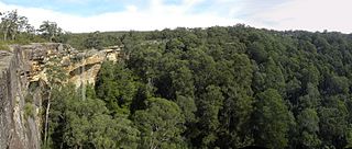
Fitzroy Falls is a village in the Wingecarribee Shire, located within the Southern Highlands region of New South Wales, Australia. The locality was known as Yarrunga, but was renamed after the 81-metre (266 ft) waterfall.

Dangarsleigh is a rural locality and minor trigonometrical station about 11 km south east of Armidale, New South Wales. The locality is at an altitude of about 1,020 metres on the Northern Tablelands in the New England region of New South Wales, Australia. The name Dangarsleigh commemorates the surveyor and pastoralist Henry Dangar’s name. It is within the Armidale Regional Council local government area and Sandon County.
Kellys Plains is a small rural locality situated about 8 kilometres west south west of Armidale, New South Wales. The settlement is at an altitude of about 1,044 metres on the Northern Tablelands in the New England region of New South Wales, Australia.

Jerangle is a locality in New South Wales, Australia. The locality is in the Snowy Monaro Regional Council local government area, 366 kilometres (227 mi) south of the state capital, Sydney and 112 kilometres (70 mi) south-east of the national capital, Canberra. At the 2016 census, Jerangle had a population of 96.

Shannons Flat is a locality in the Monaro region of New South Wales, Australia. The town is in the Snowy Monaro Regional Council local government area, sandwiched between the southern border of the Namadgi National Park in the Australian Capital Territory and the Murrumbidgee River. Shannons Flat also adjoins the NSW localities of Yaouk, Bolaro, Murrumbucca, Bredbo and Billilingra. It is about 308 kilometres (191 mi) south west of the state capital, Sydney, and 70 kilometres (40 mi) from the Australian national capital of Canberra. It is just over 40 kilometres (25 mi) north west of the regional centre, Cooma.

Royalla is a rural locality on the border of New South Wales and the Australian Capital Territory. The area takes its name from the nearby Mount Rob Roy, and was originally a railway settlement on the Bombala railway line known as Rob Roy and changed to the current name in 1905. Modern Royalla is a large rural locality east of the Monaro Highway. The border with the ACT follows the western boundary of the easement of the former railway line to the east of the highway. The town was served by a railway station until 1975. The NSW part of Royalla had a population of 984 at the 2016 census.

The Snowy Monaro Regional Council is a local government area located in the Snowy Mountains and Monaro regions of New South Wales, Australia. The council was formed on 12 May 2016 through a forced merger of the Bombala, Cooma-Monaro and Snowy River shires.

Bunyan is a locality in the Snowy Monaro Region, New South Wales, Australia. It lies on the eastern side of the Murrumbidgee River and on both sides of the Monaro Highway about 110 km south of Canberra and about 10 km north of Cooma. At the 2016 census, it had a population of 152.

Anembo is a locality in the Snowy Monaro Region, New South Wales, Australia. It lies south of Captains Flat and northeast of Bredbo. At the 2016 census, it had a population of 66. It had a public school from 1868 to 1942, often operating "half-time" or "house to house".

Jingera is a locality in the Snowy Monaro Region, New South Wales, Australia. It lies south of Captains Flat and northeast of Bredbo. At the 2016 census, it had a population of 39. It had a public school from 1889 to 1911 and from 1914 to 1941, often operating "half-time".

Dry Plain is a locality in the Snowy Monaro Region, New South Wales, Australia. It is located in grasslands mainly to the east of the Snowy Mountains Highway, about 25 km southeast of Adaminaby and 40 km northwest of Cooma, at an altitude of approximately 1,260 metres (4,130 ft). It is about 160 km south of Canberra. At the 2016 census, it had a population of 42.
Wambrook is a locality in the Snowy Monaro Region, New South Wales, Australia. It is located in grasslands mainly to the northeast of the Snowy Mountains Highway, about 30 km southeast of Adaminaby and 25 km northwest of Cooma, situated at the foot of the ranges at an altitude of 865 m above mean sea level. It is about 140 km south of Canberra. At the 2016 census, it had a population of 44.

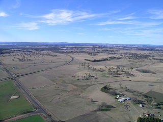
Dairymans Plains is a locality in the Snowy Monaro Region, New South Wales, Australia. It is located to the north of the Snowy Mountains Highway, to the immediate northwest of Cooma. At the 2016 census, it had a population of 152. It contains grazing country, a rural residential development, Cooma Golf Course and a large car wrecking yard.
Tianjara is a locality in the City of Shoalhaven in New South Wales, Australia. It lies generally south of the Braidwood Road between Nowra and Nerriga. It is about 47 kilometres southwest of Nowra. Tianjara is fairly rugged sandstone country and largely consists of forest. Most of it lies within the Morton National Park or state forests.
Eucumbene is a locality in the Snowy Monaro Regional Council in New South Wales, Australia. In the 2016 census, Eucumbene had a population of 12 people.
Grassdale is a rural locality in the Toowoomba Region, Queensland, Australia. In the 2021 census, Grassdale had a population of 5 people.
