
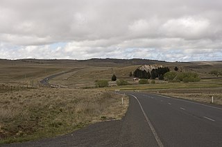
The Monaro Highway is a highway in Victoria, New South Wales, and the Australian Capital Territory, in Australia.

Monaro, once frequently spelled "Manaro", or in early years of settlement "Maneroo" is a region in the south of New South Wales, Australia. A small area of Victoria near Snowy River National Park is geographically part of the Monaro. While the Australian Capital Territory is not considered part of the region, some towns in the Monaro have close links with Canberra.
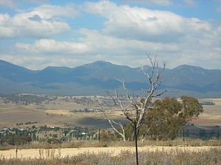
Michelago is a village in the Monaro region of New South Wales, Australia. The village is in the Snowy Monaro Regional Council local government area, 54 kilometres (34 mi) south of Canberra on the Monaro Highway. It was founded in the 1820s, on the main route from Sydney to the Snowy Mountains. At the 2016 census, Michelago had a population of 562.

Kambah is the northernmost suburb in the district of Tuggeranong, Canberra. It is located just south of Mount Taylor in the Canberra Nature Park. It is located north of the suburbs of Greenway and Wanniassa. It is bounded by Sulwood Drive to the north and Athllon Drive to the south-east.
Uriarra Village is a community in the District of Coree, Australian Capital Territory established in 1928 at the foothills of the Australian Alps. A nearby area to the north of the border in New South Wales is also called Uriarra.

Mount Stromlo is a mountain with an elevation of 770 metres (2,530 ft) AHD that is situated in the Australian Capital Territory, Australia. The mountain is most notable as the location of the Mount Stromlo Observatory. The mountain forms part of the catchment area of the Cotter River which in turn is the primary water supply for part of ACT.

The geology of the Australian Capital Territory includes rocks dating from the Ordovician around 480 million years ago, whilst most rocks are from the Silurian. During the Ordovician period the region—along with most of eastern Australia—was part of the ocean floor. The area contains the Pittman Formation consisting largely of Quartz-rich sandstone, siltstone and shale; the Adaminaby Beds and the Acton Shale.

Monaro, also known as Maneroo (1856–58), Monara (1858-1879) and Manaro (1894-1904) is an electoral district of the Legislative Assembly in the Australian state of New South Wales. It is represented by John Barilaro of The Nationals.

Williamsdale is a township in Australia, split between and located partly in the Australian Capital Territory (ACT), and partly in New South Wales (NSW). The Monaro Highway and the former Bombala railway pass through the village. A railway station saw service until 1975. The postcode is 2620. The ACT portion is located in the District of Tuggeranong.

The Bombala railway line is a branch railway line in the south of New South Wales, Australia. The northern part of it forms part of the main line from Sydney to Canberra, but the southern part is closed. It branches off the Main South line at Joppa Junction, south of Goulburn, and was opened in stages to Tarago, Bungendore, Queanbeyan, Michelago, Cooma, Nimmitabel and Bombala.

Burra is an Australian locality of rural smallholdings lying 20 kilometres to the south of Queanbeyan, New South Wales in the Queanbeyan-Palerang Region. At the 2016 census, Burra had a population of 794 people.
Rock Flat Creek is a watercourse that is part of the Murrumbidgee catchment within the Murray–Darling basin. It is located in the Monaro region of New South Wales, Australia.

The Snowy Monaro Regional Council is a local government area located in the Snowy Mountains and Monaro regions of New South Wales, Australia. The council was formed on 12 May 2016 through a merger of the Bombala, Cooma-Monaro and Snowy River shires.

Colinton is a locality in the Snowy Monaro Region, New South Wales, Australia. At the 2016 census, it had a population of 127. There was once a village and railway station of the same name.

Bunyan is a locality in the Snowy Monaro Region, New South Wales, Australia. It lies on the eastern side of the Murrumbidgee River and on both sides of the Monaro Highway about 110 km south of Canberra and about 10 km north of Cooma. At the 2016 census, it had a population of 152.

The Ingalara Creek railway bridge is a heritage-listed former railway bridge that carried the Bombala railway line across Ingalara Creek at Michelago in the Snowy Monaro Regional Council local government area of New South Wales, Australia. It was designed by John Whitton in his capacity as Engineer-in-Chief for Railways and built in 1889. It is also known as the Michelago Rail Bridge over Ingalara Creek and the Ingalara Creek Railway Viaduct. The property is owned by RailCorp, an agency of the Government of New South Wales. It was added to the New South Wales State Heritage Register on 2 April 1999. On 1 December 2020, changes were made to exemptions relating to the bridge's heritage status.

The Bredbo River railway bridge is a heritage-listed former railway bridge carrying the Bombala railway line over the Bredbo River at Bredbo in the Snowy Monaro Regional Council local government area of New South Wales, Australia. It was designed by John Whitton in his capacity as Engineer-in-Chief for Railways and built from 1881 to 1889. It is also known as the Bredbo Rail Bridge and the Bredbo River Railway Viaduct. The property is owned by RailCorp, an agency of the Government of New South Wales. It was added to the New South Wales State Heritage Register on 2 April 1999. On 1 December 2020, changes were made to exemptions relating to the bridge's heritage status.

Arnott Street Railway Bridge was a small, isolated railway bridge in Canberra, most famously used by soviet agent Vladimir Petrov in 1954 as a Dead drop location for Australian Security Intelligence Organisation (ASIO). The bridge was used as part of the Bombala railway line before it was destroyed in 2018.

Numeralla is a village in Snowy Monaro Region of New South Wales, Australia. In 2016, the population of the village and its surrounding area was 258. The village was known as Umaralla until 1972.
Bumbalong is a rural locality in the Snowy Monaro Region, New South Wales, Australia. Although it lies in the valley of the Murrumbidgee River, it is sometimes referred to by its residents as Bumbalong Valley. At the 2016 census, it had a population of 24.
