Lands administrative divisions around Currawang: | ||
Collector | Wollogorang | Yarra |
Collector | Currawang | Lake Bathurst |
Lake George | Lake George | Tarago |
Currawang is a rural locality, located to the north of Lake George. [2] in New South Wales, Australia. It lies on the intersection between three councils, with the majority straddling the boundary between the Queanbeyan–Palerang Regional Council and Goulburn-Mulwaree Council and a small portion of the locality in the Upper Lachlan Shire. There was once a mining settlement of the same name, [3] now a ghost town. It shares its name with the Currawang Parish of Argyle County, in which it is located. [4] This was formerly known as the parish of Currowang. [5] Both names derive from an Aboriginal word for the spearwood tree (Acacia doratoxylon). [2]
The area of Currawang was first inhabited by Gundungurra people, [6] who called the area Werriwa, and who were apparently badly affected by influenza in 1846/47.
An early settler in the area was Francis Kenny who, around 1824, was granted 120 acres, in the southern part of what is now Currawang, near a landform still known as Kenny's Point, on the northern shoreline of Lake George. One of Kenny's assigned convict servants was Garrett Cotter (after whom the Cotter River is named) and his absentee neighbouring landholder of was Robert Cooper. [7] [8] [9]
By the mid 1840s, the NSW colonial government had made numerous land grants in area, and both the Kenny and Cooper families had taken up more land in what is now Currawang. [10] A post office was established at Kenny's Point by 1859, [11] and there was a provisional school established there in 1867. [12] [13]
Copper was soon discovered, [14] as was gold, 7km to the west, and a town of Currawang soon sprang up. [15] [16]
The Currawang Copper Mining Company was set up in 1865 to mine the copper deposit. Surface ore had grades up to 27% copper. There was also gossan containing small amounts of gold and silver. [17] [18] Ore was smelted on site using locally-cut wood as fuel from early 1868. However, the mine had financial difficulties and closed in late 1868, being revived later as the Phoenix Mine. The new operations were managed by Eynon Deer. [19] [20] [21] In 1876, the copper smelter was owned by Lewis Lloyd. [3] The mine operated successfully for a time, but it closed in 1882, due to declining ore grades. [22]
The Phoenix Mine and the land on which it stood were up for sale in 1885. [23] More ore was discovered at the old mine, and operations recommenced under new ownership, in 1896. [24] [25] [26] However, the new company was wound up in 1897. [27] The mine dump contained significant amounts of copper, gold and silver, [28] and an attempt was made to revive the mine in 1907. In that year, the right to operate the mine was purchased by the Collins Brothers, owners of the Exeter Colliery, between Exeter and Bundanoon, and an option over it was taken up by a Melbourne syndicate. [29] [30] In 1912, it was proposed to build a water-jacket furnace to reprocess slag from the old reverberatory furnace operations; it was to use coal and coke brought from the Exeter Colliery, [31] but that did not eventuate.
In 1923, an application was made to reprocess the slag heap, but this application was refused. [32] [33] There were attempts to set up syndicates to recommence mining, in 1932 and 1933, [34] [35] but these appear to have failed. The last mining activity in the old mine was a fruitless search for uranium, in 1948. [36] [37]
The mining operations had left the land scarred and eroded—it was compared with the notorious environmental damage at Queenstown—and contaminated runoff water was entering Lake George. [38]
Just outside the locality, to the south-east off the road to Tarago—Collector Road—are the remains of a large 20th-century mine, Woodlawn Mine. In 1987, the operator of that mine began developing a previously undiscovered deposit of lead-silver-zinc sulphide ore that it had identified, in 1973, at Currawang. This time, the ore was trucked to the main Woodlawn operation closer to Tarago. Approximately 500,000 tons of high-grade ore was extracted during the mid-1990s. [38] [39]
As a part of the work, a large agricultural dam was built—diverting water away from both the old and new mine workings—the old workings were pumped out, and the old mining area was rehabilitated by scraping mining and smelting waste, into an open cut pit and elsewhere on the site, then capping it with a layer of clay. [38] [39]
It appears that the entire settlement and the mine itself lay on private landholdings, although it was served by a public road, the modern-day Currawang Road. [40] The settlement was always of a scattered nature with houses being erected close to the mine and smelter. [3] It seems never to have had any designated streets, other than the main road, despite housing a population that may have reached as high as 2,000, during the late 1860s and 1870s. [41] [38]
The town had a post office, shops, primary school and two churches. In 1876, it had around 50 houses, four stores, a blacksmith, Anglican and Wesleyan churches, two hotels (one of which also hosted Catholic services), and even a brewery. [3] The post office opened in 1866. [42] The Currawang Public School—situated on the main road to the west of the Anglican Church [43] —operated from 1870 until 1944, closing because the number of pupils declined. [44] [45] To the north of the site of the main settlement of Currawang, at Spring Valley, there was a Catholic School from 1863—predating mining at Currawang—and in 1883 a Catholic church opened there. [46] [47] [48] [49]
Many of the miners and smelters were Welsh and Wesleyan. Most of them left Currawang, as mining declined; some moved to another copper mining community, Frogmore. [15]
The little town had all but disappeared by 1948, leaving only the post office, a telephone exchange with only nine subscribers, and Anglican and Catholic churches. [36] The post office closed on 31 March 1962. [42]
In the southern part of the modern-day locality of Currawang, there was another planned settlement. In 1886, a site was reserved for a village to be officially known as Murray, on the northern shoreline of Lake George, just west of the landform known as Kenny's Point. [50] [41] [51] It is likely that the planned village took its name from, Terence Aubrey Murray, whose property, Winderradeen, was to the north of Lake George, west of Currawang, near to what is still called Murray's Lagoon. [10] [52] Although the village was surveyed and allotments put up for sale in 1887 and 1910, [53] [54] the village seems not to have developed. [51] [9] Its design was cancelled in 1919. [55] Its site was just beyond the end of modern-day Lake George Road. [56]
As a result of mine rehabilitation work, there is no obvious evidence of past mining or smelting operations today, [38] and the locality of Currawang possesses a notable rural scenic beauty. Although there is no mining in the area now, it remains of interest for mineral exploration. [39]
Pastoralism remains the dominant part of the economy, however employment also comes from the waste management facilities reusing the former mine sites, and the recently constructed. Capital Wind Farm. There is still an active Rural Fire Service Brigade.
Today the main remaining buildings are its Catholic (St Laurence O'Toole, also known as the 'Hermitage Church', at Spring Valley, opened 1883) and Anglican (St. Matthias, opened in 1875) church buildings and their associated cemeteries. [57] [58] [59] [60] St Matthias is part of the Mulwaree Mission District and has a quarterly service led by the Hon. Priest-in-Charge, Tom Frame (former Bishop to the Defence Force). The churchyard cemetery continues to be used for burials and interment of ashes.
Picnic Point on the northern shore of Lake George is named for the miner's picnics that took place there in the heyday of mining. [51] [61]
Lake George is an endorheic lake in south-eastern New South Wales, Australia. It is approximately 40 kilometres (25 mi) north-east of Canberra located adjacent to the Federal Highway en route to Canberra and Sydney. Lake George is also the name of a locality on the western and southern edges of the lake, within the area of the Queanbeyan–Palerang Regional Council.
Cobar is a town in central western New South Wales, Australia whose economy is based mainly upon base metals and gold mining. The town is 712 km (442 mi) by road northwest of the state capital, Sydney. It is at the crossroads of the Kidman Way and Barrier Highway. The town and the local government area, the Cobar Shire, are on the eastern edge of the outback. At the 2016 census, the town of Cobar had a population of 3,990. The Shire has a population of approximately 4,700 and an area of 44,065 square kilometres (17,014 sq mi).
Dalton is a small inland country town in the Southern Tablelands of New South Wales, Australia, in Upper Lachlan Shire. The population was 230 in the 2021 census.
Mongarlowe is a village in the Southern Tablelands of New South Wales, Australia in Queanbeyan-Palerang Regional Council. In former times, it was also known, in various contexts, as Little River, Monga, and Sergeants Point. The name, Mongarlowe, also applies to the surrounding area, for postal and statistical purposes.
Coombing Park is a farming property situated in western New South Wales just off the Mid-Western Highway about 5 km west of Carcoar, 260 km west of Sydney and 54 km south-west of Bathurst. The property is of considerable note because of its relationship with convicts, bushrangers and the Cobb & Co coaching company. The property was offered as an estate to its owner Thomas Icely by the early New South Wales Government in 1826. It was one of the first estates created on the western side of the Blue Mountains that border the area of Sydney.
Mount Hope is a settlement in western New South Wales, Australia. It is situated on the Kidman Way, 95 kilometres north of Hillston and 160 km south of Cobar. During the 1870s, a copper mine commenced operations at Mount Hope. In the mid-1880s, a proposed township in the area was officially surveyed and named Nombinnie, but the name has seldom been used. In the meantime, the town of Mount Hope sprang up, closer to the mine.
Yalwal is the site of a former gold mining town of the same name situated 29 km (18 mi) west of Nowra at the confluence of the Danjera and Yarramunmun Creeks which then forms Yalwal Creek which flows into the Shoalhaven River in New South Wales, Australia.
Tuena is a town in the Southern Tablelands of New South Wales, Australia, in Upper Lachlan Shire. It is located on Tuena Creek, tributary of the Abercrombie River, 269 km (167 mi) west of the state capital, Sydney. At the 2016 census, Tuena and the surrounding area had a population of 59.
Girilambone is a small village in western New South Wales, Australia. It is located north of Nyngan and 610 km north-west of Sydney. The name is also applied to the surrounding area, for postal and statistical purposes. At the 2016 census, the population of the village and its surrounding area was only 107, but it had fallen to just 86 in 2021. The village was originally associated with copper mining.
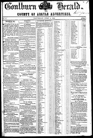
The Goulburn Herald was an English language newspaper published in Goulburn, New South Wales. At various times the paper was known as The Goulburn Herald and County of Argyle Advertiser and The Goulburn Herald and Chronicle. It is one of the earlier newspapers in the colony commencing publication more than fifty years before the federation of Australia.
The Goulburn Evening Penny Post was an English-language newspaper published in Goulburn, New South Wales, Australia from 1870 until 1957. At various times the paper was known as Goulburn Evening Penny Post, and Southern Counties General Advertiser, Goulburn and Queanbeyan Evening Penny Post and Southern Counties General Advertiser, Goulburn and Queanbeyan Evening Penny Post and Goulburn Evening Post, and later absorbed a rival newspaper, the Goulburn Herald, before finally shortening its name to the Goulburn Post.
The Argyle Liberal and District Recorder was an English language newspaper published two times per week, on Tuesdays and Fridays, in Crookwell, New South Wales, Australia.
Burraga is located in the Central Tablelands of New South Wales, 47 kilometres south west of Oberon and about 67 kilometres (42 mi) south of Bathurst. It is within Oberon Shire. At the 2016 census, Burraga had a population of 91.
Lewis Lloyd was a Welsh-born Australian mining entrepreneur and politician.
Frogmore is a village in the Southern Tablelands of New South Wales, Australia. It was previously a mining town.
Larbert is a locality in the Queanbeyan-Palerang Region of the Southern Tablelands region of New South Wales. It lies mostly north of the Kings Highway between Bungendore and Braidwood where it crosses the Shoalhaven River. At the 2021 census, it had a population of 34.
Shuttleton is an Australian ghost town located in the Parish of Hume, County of Mouramba, New South Wales. The former village site is 29 km west-south-west of Nymagee. The area in which it lies is treated as part of Nymagee for postal and statistical purposes.
Mount Allen is a ghost town in the Orana region of New South Wales, Australia. There was once a village of the same name associated with gold mining. For statistical purposes, it is considered part of Mount Hope.
Kangiara is a locality, in the Yass Valley Council local government area, within the Southern Tablelands of New South Wales, Australia. There was once a mining village of the same name.
Illewong was a mining village, now a ghost town, in the Orana region of New South Wales, Australia. Prior to 1906, it was known as Bee Mountain. The area, in which Illewong once lay, is now part of Cobar, for postal and statistical purposes.