
Albury is a major regional city in New South Wales, Australia. It is located on the Hume Highway and the northern side of the Murray River. Albury is the seat of local government for the council area which also bears the city's name – the City of Albury. It is on the Victoria–New South Wales border.

Rhodes is an Inner West suburb of Sydney, in the state of New South Wales, Australia. Rhodes is located 12 kilometres west of the Sydney central business district, in the local government area of the City of Canada Bay. It was formerly part of Concord Municipality until a merger with Drummoyne Council to form Canada Bay in December 2000. People from Rhodes are colloquially known as Rhoders or Rhodesiens.

Arncliffe is a suburb in southern Sydney, in the state of New South Wales, Australia. Arncliffe is located 11 kilometres south of the Sydney central business district, in the local government area of the Bayside Council.
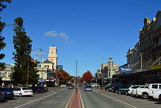
Goulburn is a regional city in the Southern Tablelands of the Australian state of New South Wales, approximately 195 kilometres (121 mi) south-west of Sydney, and 90 kilometres (56 mi) north-east of Canberra. It was proclaimed as Australia's first inland city through letters patent by Queen Victoria in 1863. Goulburn had a population of 23,835 at June 2018. Goulburn is the seat of Goulburn Mulwaree Council.

Queanbeyan is a city in the south-eastern region of New South Wales, Australia, located adjacent to the Australian Capital Territory in the Southern Tablelands region. Located on the Queanbeyan River, the city is the council seat of the Queanbeyan-Palerang Regional Council. At the 2021 census, the Queanbeyan part of the Canberra–Queanbeyan built-up area had a population of 37,511.

Bombala is a town in the Monaro region of south-eastern New South Wales, Australia, in Snowy Monaro Regional Council. It is approximately 485 kilometres (301 mi) south of the state capital, Sydney, and 80 kilometres (50 mi) south of the town of Cooma. The name derives from an Aboriginal word meaning "Meeting of the waters". The town lies on the banks of the Bombala River. At the 2016 census, Bombala had a population of 1,387.

Alexandria is an inner southern suburb of Sydney, New South Wales, Australia. Alexandria is located 5 kilometres south of the Sydney central business district and is part of the local government area of the City of Sydney. The postcode is 2015.
Michelago is a village in the Monaro region of New South Wales, Australia. The village is in the Snowy Monaro Regional Council local government area, 54 kilometres (34 mi) south of Canberra on the Monaro Highway. It was founded in the 1820s, on the main route from Sydney to the Snowy Mountains. At the 2016 census, Michelago had a population of 562.

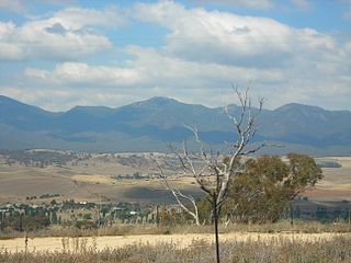
Bredbo is a village on the Monaro plains of New South Wales, Australia. The village is on the Monaro Highway 34 kilometres (21 mi) north of Cooma. The village is in the Snowy Monaro Regional Council and had a population of 352 at the 2016 census.
Oaks Estate is a suburb in the district of Jerrabomberra, Canberra, Australian Capital Territory in Australia. Is situated on the northern side of the Australian Capital Territory and New South Wales border abutting the town of Queanbeyan in south-eastern New South Wales, Australia. The estate covers an area of approximately 40 hectares and is bound by the Molonglo River to the north, the Queanbeyan River to the east, 'The Oaks' to the west, and the Queanbeyan-Cooma railway to the south. Oaks Estate is located 12 kilometres from the centre of Canberra. The village is also noteworthy as the nucleus of Queanbeyan's industrial development during the second half of the 19th century. Oaks Estate takes its name from 'The Oaks', which was part of Duntroon, Robert Campbell's farming estate. This makes Oaks Estate one of only a few place names in the ACT with significant connections to early colonial times.

The Bombala railway line is a branch railway line in the south of New South Wales, Australia. The northern part of it forms part of the main line from Sydney to Canberra, but the southern part is closed. It branches off the Main South line at Joppa Junction, south of Goulburn. The line is used by NSW TrainLink Xplorer services running between Sydney Central and Canberra station.
Environa is a suburb and locality of Queanbeyan, located in the Queanbeyan–Palerang Regional Council, in New South Wales, Australia, west of Jerrabomberra Creek and nearby the New South Wales and Australian Capital Territory border. The suburb was historically designated as a planned community that subsequently did not come to fruition, however, Environa has since been allocated as part of the South Jerrabomerra development of Queanbeyan for proposed development, including the proposed developments of Tralee and Poplars.

Carwoola is a locality in the state of New South Wales, Australia. It is immediately to the south of the Kowen district, which is located in the Australian Capital Territory. The Molonglo River passes through the Carwoola area before opening out into the Molonglo Plains. The Kings Highway and Captains Flat Road are the two major through routes. Carwoola is part of the Queanbeyan-Palerang Regional Council and the Southern Tablelands geographic area. The area also roughly aligns with the original Carwoola Parish.
The Queanbeyan Nature Reserve is a protected nature reserve that is located in the Southern Tablelands region of New South Wales, in eastern Australia. The 67-hectare (170-acre) reserve is situated approximately 4 kilometres (2.5 mi) west-south-west of the City of Queanbeyan.
Burbong is a former railway station which was located on the Bombala railway line, that leaves the main Sydney-Melbourne line at Joppa Junction. It served the Burbong and the surrounding area, which is part of the locality of Carwoola to the east of Queanbeyan in the Monaro Region of New South Wales, Australia.

The Snowy Monaro Regional Council is a local government area located in the Snowy Mountains and Monaro regions of New South Wales, Australia. The council was formed on 12 May 2016 through a forced merger of the Bombala, Cooma-Monaro and Snowy River shires.

Colinton is a locality in the Snowy Monaro Region, New South Wales, Australia. At the 2016 census, it had a population of 127. There was once a village and railway station of the same name.

Michelago railway station is a heritage-listed former railway station on the Bombala railway line at Michelago, Snowy Monaro Regional Council, New South Wales, Australia. The property was added to the New South Wales State Heritage Register on 2 April 1999.

The Ingalara Creek railway bridge is a heritage-listed former railway bridge that carried the Bombala railway line across Ingalara Creek at Michelago in the Snowy Monaro Regional Council local government area of New South Wales, Australia. It was designed by John Whitton in his capacity as Engineer-in-Chief for Railways and built in 1889. It is also known as the Michelago Rail Bridge over Ingalara Creek and the Ingalara Creek Railway Viaduct. The property is owned by Transport Asset Holding Entity, an agency of the Government of New South Wales. It was added to the New South Wales State Heritage Register on 2 April 1999. On 1 December 2020, changes were made to exemptions relating to the bridge's heritage status.

The Queanbeyan railway bridges over Queanbeyan and Molonglo Rivers are two heritage-listed railway bridges that carry the Bombala railway line in the Queanbeyan-Palerang Region local government area of New South Wales, Australia. Both bridges were built between 1926 and 1927. The westernmost bridge crosses the Queanbeyan River from Queanbeyan to Queanbeyan East at 35.3424°S 149.2317°E, while the easternmost bridge crosses the Molonglo River at Burbong at 35.3371°S 149.3191°E. The two railway bridges are owned by Transport Asset Holding Entity, an agency of the Government of New South Wales. Together, the two bridges were added to the New South Wales State Heritage Register on 2 April 1999.


