
Queanbeyan is a city in south-eastern region of the Australian state of New South Wales, located adjacent to the Australian Capital Territory in the Southern Tablelands region. Located on the Queanbeyan River, the city is the council seat of the Queanbeyan-Palerang Regional Council. At the 2016 census, the Queanbeyan part of the Canberra–Queanbeyan built-up area had a population of 36,348.

Narrabundah is a leafy, medium density suburb of Canberra, Australian Capital Territory, located in the inner south of the city.
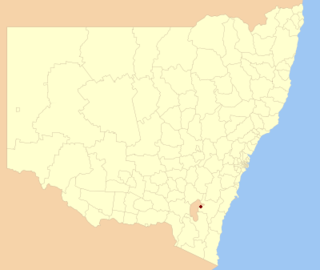
Queanbeyan City was a local government area located in south eastern New South Wales, Australia. The former area is located adjacent to Canberra and the Australian Capital Territory, the Queanbeyan River, the Molonglo River, the Kings Highway and the Sydney-Canberra railway.

Taylor is a suburb in Gungahlin, Canberra, Australia. Development of the suburb began in 2017. It is named after magazine publisher Florence Mary Taylor, who was editor of and writer for several Australian building industry journals including the influential Building magazine. The suburb is approximately 4 km from the Gungahlin Town Centre and 16 km from the centre of Canberra and bounded to the south by Horse Park Drive. One Tree Hill lies to the northwest on the border with New South Wales. The suburb is located in north Gungahlin adjacent to the suburbs of Moncrieff, Casey, Jacka and Ngunnawal.

Hume is a suburb of Canberra in the District of Jerrabomberra. The suburb is named after the explorer Hamilton Hume and streets are named after Australian industrialists and businessmen. Hume is a light-industrial suburb and there is no significant housing development. At the 2016 census, Hume had a population of 430, up from six in 2006, as a result of the construction of the Alexander Maconochie Centre. The location of the prison has also given Hume a highly unusual sex ratio with 93.4% of the population being male.

Belconnen is the most inner suburb of the larger district of Belconnen in Canberra, Australia. Sharing its name with the larger district which encapsulates it, the suburb is surrounded with well developed infrastructure, and planning which allows it sunset views from the Brindabellas on its western side. The suburb contains important amenities for the District of Belconnen including the Belconnen Town Centre and Lake Ginninderra as well as its own well populated residential areas. It is bounded by Ginninderra Drive, Aikman Drive, Eastern Valley Way, Belconnen Way and Coulter Drive. It has a number of parks such as Margaret Timpson Park, Eastern Valley Oval, and on the foreshores of Lake Ginninberra, Diddams Close Park and John Knight Memorial Park.

Scullin is a residential suburb in the Belconnen district of Canberra, located within the Australian Capital Territory, Australia. The suburb is named after Prime Minister of Australia James Henry Scullin. It was gazetted on 6 June 1968. In the city of Canberra, suburbs are assigned street names that reflect a distinct sub-group of cultural or historical Australian significance. The streets in the suburb of Scullin are named after aviators. Scullin is located adjacent to the suburbs of Higgins, Florey, Page and Hawker. Southern Cross Early Childhood School and Scullin neighbourhood oval are located within the suburb. It is bordered by Kingsford Smith Drive, Belconnen Way, Southern Cross Drive and Chewings Street. Scullin is approximately 20 minutes walk and 5 minutes by car from the Belconnen Town Centre and 15 minutes walk and 3 minutes by car from the Hawker Shopping Centre. It is approximately 10 to 15 minutes by car from Canberra City and 30 minutes from Canberra Airport.
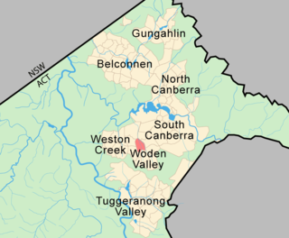
Phillip is a suburb of Canberra, Australia in the district of Woden Valley. It is located in the centre of the district and contains the district's main commercial centre, Woden Town Centre. Phillip had a residential population of 2,936 at the 2016 census. 47.9% of its occupied dwellings were flats and 51.9% were semi-detached, terraces or townhouses. Many more flats are being planned or built.

Oaks Estate is a township situated immediately on the northern side of the New South Wales - Australian Capital Territory border abutting the township of Queanbeyan in south-eastern New South Wales, Australia. The estate covers an area of approximately 40 hectares and is bound by the Molonglo River to the north, the Queanbeyan River to the east, 'The Oaks' to the west, and the Queanbeyan-Cooma railway to the south. Oaks Estate is located 12 kilometres from the centre of Canberra. The village is also noteworthy as the nucleus of Queanbeyan's industrial development during the second half of the 19th century. Oaks Estate takes its name from 'The Oaks', which was part of Duntroon, Robert Campbell's farming estate. This makes Oaks Estate one of only a few place names in the ACT with significant connections to early colonial times.

Uriarra Village is a community in the District of Coree, Australian Capital Territory established in 1928 at the foothills of the Australian Alps. A nearby area to the north of the border in New South Wales is also called Uriarra.

Williamsdale is a township in Australia located partly in the Australian Capital Territory (ACT) and partly in New South Wales (NSW). The Monaro Highway and the former Bombala railway pass through the village. A railway station saw service until 1975. The postcode is 2620.

The Palerang Council was a local government area located in the Southern Tablelands region of New South Wales, Australia. On 12 May 2016 the Minister for Local Government announced dissolution of the Palerang Council with immediate effect. Together with Queanbeyan City the combined council areas were merged to establish the Queanbeyan-Palerang Regional Council. Both councils had opposed the amalgamation. Elections for the new Council area were held in September 2017. The former mayor of Queanbeyan City Council was appointed by the NSW Government as administrator until that date.
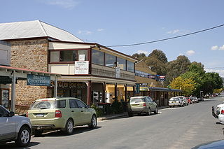
Bungendore is a town in the Queanbeyan Region of New South Wales, Australia, in Queanbeyan-Palerang Regional Council. It is on the Kings Highway near Lake George, the Molonglo River Valley and the Australian Capital Territory border. It has become a major tourist centre in recent years, popular with visitors from Canberra and some of it has heritage protection. It has expanded rapidly in recent years as a dormitory town of Canberra.

Googong is a suburb of Queanbeyan and is located within the Queanbeyan–Palerang Regional Council local government area, located to the south of the Queanbeyan CBD.

Burra is an Australian locality of rural smallholdings lying 20 kilometres to the south of Queanbeyan, New South Wales in the Queanbeyan-Palerang Region. At the 2016 census, Burra had a population of 794 people.

Environa is a suburb and locality of Queanbeyan, located in the Queanbeyan–Palerang Regional Council, in New South Wales, Australia, nearby the New South Wales and Australian Capital Territory border. The suburb was historically designated as a planned community that subsequently did not come to fruition, however, Environa had since been allocated as part of the South Jerrabomerra development of Queanbeyan for proposed development, including the proposed developments of Tralee and Poplars.
Denman Prospect is a suburb currently under development in the Molonglo Valley district of Canberra, located within the Australian Capital Territory, Australia.

The Queanbeyan Nature Reserve is a protected nature reserve that is located in the Southern Tablelands region of New South Wales, in eastern Australia. The 67-hectare (170-acre) reserve is situated approximately 4 kilometres (2.5 mi) west-south-west of the City of Queanbeyan.
Whitlam is a future suburb in the Molonglo Valley, Australian Capital Territory. The suburb is named after former prime minister Gough Whitlam. Many Canberra suburbs are named after prime ministers or other politicians, but only at least a year post death. The ACT government waited a year before announcing a suburb named Whitlam. Whitlam is the northernmost suburb in the Molonglo Valley district, positioned to the north of Denman Prospect.
Parkwood is a suburb of Yass Valley Council in New South Wales, Australia.
