Hoskinstown, New South Wales

Last updated

Hoskinstown
New South Wales
House at Hoskinston, New South Wales.jpg
House at Hoskinstown, which was once a part of the Victoria Hotel building.
Australia New South Wales location map blank.svg
Red pog.svg
Hoskinstown
Location in New South Wales
Coordinates 35°24′57″S149°27′02″E / 35.41583°S 149.45056°E / -35.41583; 149.45056 Coordinates: 35°24′57″S149°27′02″E / 35.41583°S 149.45056°E / -35.41583; 149.45056
Population189 (2016 census) [1]
Postcode(s) 2621
Elevation761 m (2,497 ft)
Location
LGA(s) Queanbeyan-Palerang Regional Council
Region Southern Tablelands
County Murray
Parish Molonglo
State electorate(s) Monaro
Federal division(s) Eden-Monaro
Localities around Hoskinstown:
Bungendore Bungendore Bungendore
Carwoola Hoskinstown Forbes Creek
Primrose Valley Captains Flat Rossi

Hoskinstown is a locality in Queanbeyan-Palerang Regional Council, New South Wales, Australia. [2] The locality, and what remains of the cluster of settlement of the same name, is 38 km southeast of Canberra the Capital city of Australia, and 299 km southwest of Sydney. At the 2016 census, it had a population of 189. [1]

The area now known as Hoskinstown lies on the traditional lands of Ngarigo people. [3] [4]

Hoskinstown, was known previously as Hoskingtown; it was named after John Hosking (1805-1882), a Sydney merchant, first elected mayor of Sydney, and the owner of the nearby Foxlow station—its name was derived from his wife Martha's middle name—which he took up around 1835. [5] Part of what was once Hoskings' landholding extented to part of the area occupied by the settlement at Hoskinstown. [6]

The area lay of a road route, between Queanbeyan and Braidwood. Prior to 1870, it was known as 'Blackheath', a name in use since at least as early as 1835. Possibly due to confusion with the newer Blue Mountains township of Blackheath, the name of the post office at 'Blackheath' was changed, in 1870, to 'Hoskins Town'. From around the same time, the name for the small settlement and its surrounding area became 'Hoskingtown', until around 1896, when it became Hoskinstown. [7] [8] [9] [10] [11] Its name has been variously spelt as 'Hoskingtown', 'Hoskingstown', 'Hoskins Town', 'Hoskington', and 'Hoskintown', before the most commonly used name, Hoskinstown, became used universally. [5] [12] [13] [14]

Hoskinstown's urban portion seems never to have been proclaimed a village—possibly another reason for the confusion about the spelling of its name—and was best described as a cluster of settlement; it was centred on Hoskinstown Road, roughly between modern-day Plains Road and Rossi Road. [15] [16]

Hoskinstown is known for the Molonglo Observatory Synthesis Telescope operated by the University of Sydney.

It had a public school from 1869 to 1967, [17] aside from a mysterious event, in 1934, when the building was partially dismantled, without notice or explanation, but then restored. [18] [19] [20] The site of the school was excised from land that was once owned by John Hosking. [6]

Captains Flat railway line at Hoskinstown Railway at Hoskinstown, New South Wales.jpg
Captains Flat railway line at Hoskinstown

Hoskinstown platform was opened along with the Captains Flat railway line in 1940, and it closed, in August 1968, a year before the line. [21] It was a small short-platform structure. [22]

The settlement once had a hotel, the Victoria Hotel. [23] [24] During the 1930s, a house that contained the post office and store also seems to have operated, at times, as a 'sly grog' outlet. [25] The post office closed at the end of November 1967.

The Catholic Church is dedicated to Saint Peter and Paul. There is also an Anglican Church, St Marks. Both of the churches have a cemetery. During the years when there was widespread sectarianism in Australia, Hoskinstown was a notable exception, with the two churches holding combined social and sporting events, with the funds raised being shared. [26] [27] [28] [29] [30] Hoskinstown has a public hall that opened in 1928. [31] [15]

Related Research Articles

Molonglo River

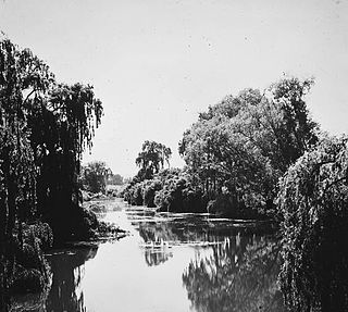
The Molonglo River, a perennial river that is part of the Murrumbidgee catchment within the Murray–Darling basin, is located in the Monaro and Capital Country regions of New South Wales and the Australian Capital Territory, in Australia.

Austin Chapman Australian politician (1864—1926)

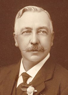
Sir Austin Chapman was an Australian politician who served in the House of Representatives from 1901 until his death in 1926. He held ministerial office in the governments of Alfred Deakin and Stanley Bruce, serving as Minister for Defence (1903–1904), Postmaster-General (1905–1907), Minister for Trade and Customs, and Minister for Health (1923–1924).

Queanbeyan River

The Queanbeyan River, a perennial stream that is part of the Molonglo catchment within the Murray–Darling basin, is located in the Monaro and Capital Country regions of New South Wales and the Australian Capital Territory, in Australia. The river is 104 kilometres (65 mi) in length with a catchment area of 96,000 hectares. The Queanbeyan River and the Cotter River meet the potable water supply needs of the Canberra and Queanbeyan region and whose water quality is specifically protected under Federal legislation.

Electoral district of Monaro

Monaro, also known as Maneroo (1856–58), Monara (1858-1879) and Manaro (1894-1904) is an electoral district of the Legislative Assembly in the Australian state of New South Wales. It was previously represented by John Barilaro of The Nationals.

Palerang Council Local government area in New South Wales, Australia

The Palerang Council was a local government area located in the Southern Tablelands region of New South Wales, Australia. On 12 May 2016 the Minister for Local Government announced dissolution of the Palerang Council with immediate effect. Together with Queanbeyan City the combined council areas were merged to establish the Queanbeyan-Palerang Regional Council. Both councils had opposed the amalgamation. Elections for the new Council area were held in September 2017. The former mayor of Queanbeyan City Council was appointed by the NSW Government as administrator until that date.

Bungendore Town in New South Wales, Australia

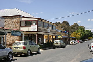
Bungendore is a town in the Queanbeyan Region of New South Wales, Australia, in Queanbeyan-Palerang Regional Council. It is on the Kings Highway near Lake George, the Molonglo River Valley and the Australian Capital Territory border. It has become a major tourist centre in recent years, popular with visitors from Canberra and some of it has heritage protection. It has expanded rapidly in recent years as a dormitory town of Canberra.

Molonglo Plain

The Molonglo Plain generally refers to the flood plain of the Molonglo River and specifically the one located in the Australian Capital Territory that was inundated during the mid-1960s in order to create Lake Burley Griffin. This plain was one of fours plains - the Ginninderra Plain, the Limestone Plain, and the Tuggeranong Plain are the others - upon which the city of Canberra is situated.

Bombala railway line

The Bombala railway line is a branch railway line in the south of New South Wales, Australia. The northern part of it forms part of the main line from Sydney to Canberra, but the southern part is closed. It branches off the Main South line at Joppa Junction, south of Goulburn. The line is used by NSW TrainLink Xplorer services running between Sydney Central and Canberra station.

Ngambri is an Aboriginal name for a locality in the southeast of Australia, near the centre of what is now Australia's capital city of Canberra. The area is close to Black Mountain along Sullivans Creek down to the Yeelamgigee, now Molonglo River. The extent of recognised Ngambri territory, and of their distinction from the Walgalu, has been the subject of controversy in recent years. Canberra, where Ngambri claims are made, lay close to the tribal boundaries that separated the Ngarigo from the Ngunawal.

The Captains Flat railway line was a country branch line in the Southern Tablelands region of New South Wales. The line branched off the Bombala line at Bungendore Junction, 5 km south of Bungendore and terminated 34 km further south at Captain's Flat.

<i>Goulburn Evening Penny Post</i>

The Goulburn Evening Penny Post was an English-language newspaper published in Goulburn, New South Wales, Australia from 1870 until 1957. At various times the paper was known as Goulburn Evening Penny Post, and Southern Counties General Advertiser, Goulburn and Queanbeyan Evening Penny Post and Southern Counties General Advertiser, Goulburn and Queanbeyan Evening Penny Post and Goulburn Evening Post, and later absorbed a rival newspaper, the Goulburn Herald, before finally shortening its name to the Goulburn Post.

Carwoola Town in New South Wales, Australia

Carwoola is a locality in the state of New South Wales, Australia. It is immediately to the south of the Kowen district, which is located in the Australian Capital Territory. The Molonglo River passes through the Carwoola area before opening out into the Molonglo Plains. The Kings Highway and Captains Flat Road are the two major through routes. Carwoola is part of the Queanbeyan-Palerang Regional Council and the Southern Tablelands geographic area. The area also roughly aligns with the original Carwoola Parish.

Currawang Cadastral in New South Wales, Australia

Currawang is a locality in the Queanbeyan–Palerang Regional Council, on the edges of Upper Lachlan Shire and Goulburn-Mulwaree Council, in New South Wales, Australia. It is located to the north of Lake George. It shares its name with the Currawang Parish of Argyle County, in which it is located. This was formerly known as the parish of Currowang. Both names derive from an Aboriginal word for the spearwood tree.

Queanbeyan–Palerang Regional Council Local government area in New South Wales, Australia

Queanbeyan–Palerang Regional Council is a local government area located in the Southern Tablelands region of New South Wales, Australia. The council was formed on 12 May 2016 through a merger of the City of Queanbeyan and Palerang Council.

Colinton, New South Wales Town in New South Wales, Australia

Colinton is a locality in the Snowy Monaro Region, New South Wales, Australia. At the 2016 census, it had a population of 127. There was once a village and railway station of the same name.

Larbert, New South Wales Town in New South Wales, Australia

Larbert is a locality in the Queanbeyan-Palerang Region of the Southern Tablelands region of New South Wales. It lies mostly north of the Kings Highway between Bungendore and Braidwood where it crosses the Shoalhaven River. At the 2016 census, it had a population of 39.

Mulloon Town in New South Wales, Australia

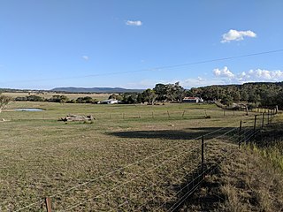
Mulloon is a locality in the Queanbeyan-Palerang Region, Southern Tablelands, New South Wales, Australia. At the 2016 census, it had a population of 144.

Christ Church, Queanbeyan Church in New South Wales, Australia

Christ Church is a heritage-listed Anglican church at Rutledge Street, Queanbeyan, Queanbeyan-Palerang Region, New South Wales, Australia. It was built from 1859 to 1860. The property is owned by the Anglican Church Property Trust. It was added to the New South Wales State Heritage Register on 2 April 1999.

Queanbeyan railway bridges over Queanbeyan and Molonglo Rivers

The Queanbeyan railway bridges over Queanbeyan and Molonglo Rivers are two heritage-listed railway bridges that carry the Bombala railway line in the Queanbeyan-Palerang Region local government area of New South Wales, Australia. Both bridges were built between 1926 and 1927. The westernmost bridge crosses the Queanbeyan River from Queanbeyan to Queanbeyan East at 35.3424°S 149.2317°E, while the easternmost bridge crosses the Molonglo River at Burbong at 35.3371°S 149.3191°E. The two railway bridges are owned by RailCorp, an agency of the Government of New South Wales. Together, the two bridges were added to the New South Wales State Heritage Register on 2 April 1999.

James Larmer

James Larmer was a government surveyor in the colony of New South Wales. Between 1830 and 1859, he surveyed land, roads and settlements in New South Wales. He was an Assistant Surveyor to the Surveyor-General, Sir Thomas Mitchell, from 1835 to 1855. In 1835, he was second in command of Mitchell’s second expedition. He is also noteworthy for his recording of Aboriginal words from various parts of New South Wales.

References

  1. 1 2 Australian Bureau of Statistics (27 June 2017). "Hoskinstown (state suburb)". 2016 Census QuickStats. Retrieved 29 June 2017. OOjs UI icon edit-ltr-progressive.svg
  2. "Hoskinstown". Geographical Names Register (GNR) of NSW. Geographical Names Board of New South Wales . Retrieved 30 July 2017. OOjs UI icon edit-ltr-progressive.svg
  3. "About the Ngambri - refer to map of sites for Ngarigo-speakers". www.ngambri.org. Retrieved 19 January 2022.{{cite web}}: CS1 maint: url-status (link)
  4. Studies, Australian Institute of Aboriginal and Torres Strait Islander (10 January 2021). "Map of Indigenous Australia". aiatsis.gov.au. Retrieved 19 January 2022.
  5. 1 2 "History of Carwoola". Carwoola Commuity. Retrieved 23 January 2022.
  6. 1 2 Department of Lands, Sydney, N.S.W. (1962). "Parish of Molonglo, County of Murray [cartographic material] : Land District of Queanbeyan, Yarrowlumla Shire, Eastern Division N.S.W. & Austn. Capital Territory". trove.nla.gov.au. Retrieved 26 January 2022.{{cite web}}: CS1 maint: multiple names: authors list (link)
  7. "Index page". New South Wales Government Gazette. 31 December 1870. Retrieved 30 January 2022.
  8. "NSW Place and Road Naming Proposals System - Hoskinstown (Rural Place)". proposals.gnb.nsw.gov.au. Retrieved 30 January 2022.
  9. "NSW Place and Road Naming Proposals System - Hoskinstown (Locality)". proposals.gnb.nsw.gov.au. Retrieved 30 January 2022.
  10. "Government Gazette Notices". New South Wales Government Gazette. 2 December 1835. Retrieved 31 January 2022.
  11. "GOVERNMENT GAZETTE". Sydney Herald. 4 November 1841. Retrieved 30 January 2022.
  12. Parsons, Vivienne, "Hosking, John (1806–1882)", Australian Dictionary of Biography, Canberra: National Centre of Biography, Australian National University, retrieved 25 January 2022
  13. "HOSKINGTOWN". Queanbeyan Age. 31 August 1871. Retrieved 30 January 2022.
  14. "FRIDAY, DECEMBER 23". Goulburn Herald and Chronicle. 24 December 1870. Retrieved 30 January 2022.
  15. 1 2 "Satellite View - Hoskinstown Community Hall · 1697 Hoskinstown Rd, Hoskinstown NSW 2621, Australia". Google Maps. Retrieved 24 January 2022.
  16. "Hoskinstown Community Hall · 1697 Hoskinstown Rd, Hoskinstown NSW 2621, Australia". Google Maps. Retrieved 24 January 2022.
  17. "Hoskinstown Public School in the School history database search". New South Wales Department of Education. Retrieved 25 December 2017.
  18. "SCHOLARS ARRIVE BUT NO SCHOOL - HOSKINSTOWN SURPRISE". Goulburn Evening Penny Post. 2 February 1934. Retrieved 23 January 2022.
  19. "HOSKINSTOWN - BUILT IT UP AGAIN - SCHOOL MYSTERY". Goulburn Evening Penny Post. 8 February 1934. Retrieved 23 January 2022.
  20. "DAY THEY PULLED THE SCHOOL-HOUSE DOWN!". Smith's Weekly. 5 May 1934. Retrieved 23 January 2022.
  21. "Hoskinstown Platform". NSWRail.net. Retrieved 25 December 2017.
  22. "Hoskinstown Railway Station on the now closed Bungendore to Captains Flat railway line in New South Wales, ca. 1970 [picture]". Trove. Retrieved 23 January 2022.
  23. "MEMBERS BEFORE THEIR CONSTITUENTS". Daily Telegraph. 1 October 1888. Retrieved 23 January 2022.
  24. "License Reduction Board". Queanbeyan Age and Queanbeyan Observer. 14 March 1924. Retrieved 23 January 2022.
  25. "SLY GROG CHARGE AT HOSKINSTOWN". Braidwood Review and District Advocate. 11 October 1938. Retrieved 23 January 2022.
  26. Australian Cemeteries Index - Cemetery 1588 - Hoskinstown Catholic Church
  27. Australian Cemeteries Index - Cemetery 1587 - Hoskinstown Anglican Church
  28. "Contact". Anglican Parish of Bungendore. Retrieved 23 January 2022.{{cite web}}: CS1 maint: url-status (link)
  29. "HOSKINS TOWN". Goulburn Evening Penny Post. 2 February 1926. Retrieved 30 January 2022.
  30. "CHURCHES COMBINE". Goulburn Evening Penny Post. 14 February 1928. Retrieved 30 January 2022.
  31. "HOSKINSTOWN HALL, Brilliant Fancy Dress Ball". Goulburn Evening Penny Post. 27 July 1928. Retrieved 23 January 2022.