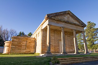
Berrima is a historic village in the Southern Highlands of New South Wales, Australia, in Wingecarribee Shire. The village, once a major town, is located on the Old Hume Highway between Sydney and Canberra. It was previously known officially as the Town of Berrima. It is close to the three major towns of the Southern Highlands: Mittagong, Bowral and Moss Vale.

Mittagong is a town located in the Southern Highlands of New South Wales, Australia, in Wingecarribee Shire. The town acts as the gateway to the Southern Highlands when coming from Sydney. Mittagong is situated at an elevation of 635 metres (2,083 ft). The town is close to Bowral, Berrima, Moss Vale and the Northern Villages such as Yerrinbool and Colo Vale. Moreover, Mittagong is home to many wineries of the Southern Highlands which has been a recent growing wine and cellar door region.

Elizabeth Bay is a harbourside suburb in eastern Sydney, in the state of New South Wales, Australia. Elizabeth Bay is located three kilometres east of the Sydney central business district and is part of the local government area of the City of Sydney.
Mount Murray is a mountain in New South Wales, Australia with an elevation of 780 metres above sea level. It is located six kilometres outside Robertson. The mountain is named after Sir George Murray. Mount Murray is also the name of a location at the top of the Macquarie Pass on the Illawarra Highway.
Burradoo is a suburb of Bowral, in the Southern Highlands of New South Wales, Australia, in Wingecarribee Shire.

Wee Jasper is a hamlet in the Goodradigbee valley at the western foot of the Brindabella Ranges, near Burrinjuck Dam in New South Wales, Australia in Yass Valley Shire. It is located about 90 km north-west of Canberra and 60 km south-west of Yass. At the 2021 census, Wee Jasper and the surrounding area had a population of 127.

Araluen is a small town near Braidwood in the Southern Tablelands of New South Wales, Australia, in Queanbeyan-Palerang Regional Council. It lies in the valley of Araluen Creek, that joins the Deua River at roughly the midpoint in its course. At the 2021 census, Araluen had a population of 209 people.
Bathurst Regional Council is a local government area in the Central West region of New South Wales, Australia. The area is located adjacent to the Great Western Highway, Mid-Western Highway, Mitchell Highway and the Main Western railway line. At the 2016 census, the Bathurst Region had a population of 41,300.

Abernethy is a small town in the City of Cessnock, in the Hunter Region in the state of New South Wales, Australia. Abernethy is located 8 kilometres south-east of the town of Cessnock, NSW and is adjacent to Werakata National Park and the Aberdare State Forest. The town was founded near a coal mine and some of the historic buildings remain. In 2016 348 lived there with the median age being 32 and 74.8% being born in Australia.
Cunninyeuk is a locality in the Murray River Council, New South Wales, Australia.

Collector is a small village on the Federal Highway in New South Wales, Australia halfway between Goulburn and the Australian Capital Territory. It is seven kilometres north of Lake George. At the 2021 census, Collector and the surrounding district had a population of 376 people.
Marinna is a locality in Junee Shire in southern New South Wales, Australia. Its main feature is a grain silo on the Main South railway line. A station was opened in the locality between 1897 and 1975.

Queanbeyan–Palerang Regional Council is a local government area located in the Southern Tablelands region of New South Wales, Australia. The council was formed on 12 May 2016 through a merger of the City of Queanbeyan and Palerang Council.
Bishops Bridge is a locality in the cities of Cessnock and Maitland in the Hunter Region of New South Wales, Australia. At the 2021 Census, the population was 218, the median age was 43 and 92% born in Australia.

Ballalaba is a locality in the Queanbeyan–Palerang Regional Council, New South Wales, Australia. It is located about 30 km southwest of Braidwood on the road to Cooma and on the Shoalhaven River. At the 2021 census, it had a population of 29. It had a "half-time" school from 1867 to 1870; from 1879 to 1940, it operated either as a "provisional" or a "half-time" school".
Farringdon is a locality in the Queanbeyan–Palerang Regional Council, New South Wales, Australia. It is located about 17 km southwest of Braidwood on the western bank of the Shoalhaven River. At the 2016 census, it had a population of 14.

Bombay is a locality in the Queanbeyan–Palerang Regional Council, New South Wales, Australia. It is located about 14 km southwest of Braidwood on the western bank of the Shoalhaven River. At the 2021 census, it had a population of 142. It has two areas of somewhat denser settlement described as "Bombay" and "Little Bombay". It had a school in 1871 and from 1873 to 1928, normally described as "Bombay Half-Time School" but sometimes as "Bombay Provisional School".
Berlang is a locality in Queanbeyan-Palerang Regional Council, New South Wales, Australia. It was previously called Tallaganda. The town lies about 44 km south of Braidwood on the upper Shoalhaven River and the road to Cooma. At the 2021 census, it had a population of none. It includes part of the Deua National Park and the Berlang State Conservation Area. The Big Hole is a notable geological feature in the locality and the Deua National Park.
Yarrangobilly, New South Wales is a rural locality in the Snowy Mountains, west of Canberra, Australia, and is also a civil Parish of Buccleuch County.

Berremangra is a locality in the Hilltops Council, New South Wales, Australia. It is on both sides of the Hume Highway about 45 km west of Yass.

