
Braidwood is a town in the Southern Tablelands of New South Wales, Australia, in Queanbeyan–Palerang Regional Council. It is located on the Kings Highway linking Canberra with Batemans Bay. It is approximately 200 kilometres south west of Sydney, 60 kilometres inland from the coast, and fifty-five from Canberra. Braidwood is a service town for the surrounding district which is based on sheep and cattle grazing, and forestry operations.
Queanbeyan City was a local government area located in south eastern New South Wales, Australia. The former area is located adjacent to Canberra and the Australian Capital Territory, the Queanbeyan River, the Molonglo River, the Kings Highway and the Sydney-Canberra railway.

The Palerang Council was a local government area located in the Southern Tablelands region of New South Wales, Australia. On 12 May 2016 the Minister for Local Government announced dissolution of the Palerang Council with immediate effect. Together with Queanbeyan City the combined council areas were merged to establish the Queanbeyan-Palerang Regional Council. Both councils had opposed the amalgamation. Elections for the new Council area will be held in September 2017. The former mayor of Queanbeyan City Council was appointed by the NSW Government as administrator until that date.
Tallaganda Shire, was a local government area in New South Wales centered on Braidwood, New South Wales It lasted from colonial times until February 2004, when the local government organisation was absorbed into newly created Palerang Council.
Primrose Valley is a locality in the Queanbeyan–Palerang Regional Council area, New South Wales, Australia. It is located on the road from Queanbeyan to Captains Flat about 33 km southeast of Queanbeyan and 25 km north of Captains Flat. At the 2016 census, it had a population of 146. It had a provisional school from 1884 to 1886 and a half-time school from 187 to 1889.

Forbes Creek is a locality in Queanbeyan-Palerang Regional Council, New South Wales, Australia. The town lies 45km east of Canberra. At the 2016 census, it had a population of 68. The Tallaganda National Park includes part of its eastern edge.
Harolds Cross is a locality in the Queanbeyan–Palerang Regional Council, New South Wales, Australia. It is located about 11 km northeast of Captains Flat and 35 km southwest of Braidwood. At the 2016 census, it had a population of 53. It had a "half-time" school from 1868 and 1915; from 1949 to 1857, it operated as a "provisional school".

Ballalaba is a locality in the Queanbeyan–Palerang Regional Council, New South Wales, Australia. It is located about 30 km southwest of Braidwood on the road to Cooma and on the Shoalhaven River. At the 2016 census, it had a population of 22. It had a "half-time" school from 1867 to 1870; from 1879 to 1940, it operated either as a "provisional" or a "half-time" school".

Bendoura is a locality in the Queanbeyan–Palerang Regional Council, New South Wales, Australia. It is located about 20 km southwest of Braidwood on the road to Cooma and on the eastern bank of the Shoalhaven River. At the 2016 census, it had a population of 70.
Farringdon is a locality in the Queanbeyan–Palerang Regional Council, New South Wales, Australia. It is located about 17 km southwest of Braidwood on the western bank of the Shoalhaven River. At the 2016 census, it had a population of 14. It had a "half-time" school from 1867 to 1894.

Bombay is a locality in the Queanbeyan–Palerang Regional Council, New South Wales, Australia. It is located about 14 km southwest of Braidwood on the western bank of the Shoalhaven River. At the 2016 census, it had a population of 117. It has two areas of somewhat denser settlement described as "Bombay" and "Little Bombay". It had a school in 1871 and from 1873 to 1928, normally described as "Bombay Half-Time School" but sometimes as "Bombay Provisional School".

Berlang is a locality in Queanbeyan-Palerang Regional Council, New South Wales, Australia. It was previously called Tallaganda. The town lies about 44km south of Braidwood on the upper Shoalhaven River and the road to Cooma. At the 2016 census, it had a population of none. It includes part of the Deua National Park and the Berlang State Conservation Area. The Big Hole is a notable geological feature in the locality and the Deua National Park.

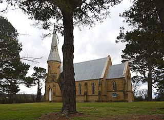
Mayfield is a locality in the Queanbeyan–Palerang Regional Council, New South Wales, Australia. It is located about 85 km east of Canberra and 58 km south of Goulburn. At the 2016 census, it had a population of 22. It had an Anglican church, St Luke's from 1895 to 1965. A "half-time" school was located at Virginia station in Mayfield from 1894 to 1899.

Northangera is a locality in the Queanbeyan-Palerang Region, Southern Tablelands, New South Wales, Australia. The name Northangera was assigned on 13 July 2001. It lies on the Kings Highway about 100 km east of Canberra and 15 km east of Braidwood. At the 2016 census, it had a population of 43. It had a "half-time" School from 1921 to 1931.

Monga is a locality in the Queanbeyan-Palerang Region, Southern Tablelands, New South Wales, Australia. It lies on the Kings Highway at the top of the Clyde Mountain, about 110 km east of Canberra and 22 km southeast of Braidwood. A large part of the locality forms part of the Monga National Park. At the 2016 census, it had a population of 14. It had a "provisional" school from 1947 to 1955 and a "public" school from 1955 to 1971.

Krawarree is a rural locality in Queanbeyan–Palerang Regional Council.

Durran Durra is a locality in the Queanbeyan–Palerang Regional Council, New South Wales, Australia. It is located on the road from Braidwood to Nowra about 15 km north of Braidwood and 100 km east of Canberra. At the 2016 census, it had a population of 107. It consists mainly of grazing country.
Tomboye is a locality in the Queanbeyan–Palerang Regional Council, New South Wales, Australia. It is located on the north side of the Mongarlowe River on the road from Braidwood to Nowra about 28 km north of Braidwood and 93 km southwest of Nowra. At the 2016 census, it had a population of 40. It consists mainly of forest and grazing country.

Wog Wog is a locality in the Queanbeyan–Palerang Regional Council, New South Wales, Australia. It is located on the south side of the Corang River and to the east of the road from Braidwood to Nowra about 34 km north of Braidwood and 96 km southwest of Nowra. At the 2016 census, it had a population of 15. It consists mainly of forest, including parts of the Morton National Park. Its eastern boundary runs along the Budawang Range and includes Wog Wog Mountain and Corang Peak.

Corang is a locality in the Queanbeyan–Palerang Regional Council, New South Wales, Australia. It is located on the north side of the Corang River and to the east of the road from Braidwood to Nowra about 46 km north of Braidwood and 75 km southwest of Nowra. At the 2016 census, it had a population of 13. It consists mainly of forest and most of it lies in the Morton National Park. Its eastern boundary runs along the Budawang Range and includes Mount Tarn, Sturgiss Mountain and Quiltys Mountain.


