
Braidwood is a town in the Southern Tablelands of New South Wales, Australia, in Queanbeyan–Palerang Regional Council. It is located on the Kings Highway linking Canberra with Batemans Bay. It is approximately 200 kilometres south west of Sydney, 60 kilometres inland from the coast, and 55 kilometres east of Canberra. Braidwood is a service town for the surrounding district which is based on sheep and cattle grazing, and forestry operations.
The Shoalhaven River is a perennial river that rises from the Southern Tablelands and flows into an open mature wave dominated barrier estuary near Nowra on the South Coast of New South Wales, Australia.

The Budawang Range, commonly called The Budawangs, a rugged mountain range within the Budawang National Park and the Morton National Park, are part of a spur off the Great Dividing Range and are located in the South Coast region of New South Wales, Australia.

Huskisson is a village in New South Wales, Australia in the City of Shoalhaven, on the shores of Jervis Bay. It is 24 km south-east of Nowra.

Mongarlowe is a village in the Southern Tablelands of New South Wales, Australia in Queanbeyan-Palerang Regional Council. In former times, it was also known, in various contexts, as Little River, Monga, and Sergeants Point.
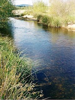
Endrick River is a perennial river of the Shoalhaven catchment located in the Southern Tablelands region of New South Wales, Australia.
Tomerong is a village in the South Coast region of New South Wales, Australia. It is located approximately 180 kilometres by road south from the state capital Sydney and 20 kilometres south of the commercial centre of the City of Shoalhaven, Nowra in the County of St Vincent. The village is eight kilometres inland of the western shores of Jervis Bay. Its population at the 2016 census was 1,065.

John Coghill (1785–1853) was an Australian politician and naval captain.

Oallen is a locality in the Goulburn Mulwaree Council area, New South Wales, Australia. It is located on the Shoalhaven River and the Oallen Ford Road about 97 km southeast of Goulburn and 106 km southwest of Nowra. The Oallen Ford Road has recently been upgraded to improve the connection from Canberra and Goulburn to Nerriga, Nowra and Jervis Bay. At the 2016 census, Oallen had a population of 141.

Sassafras is a locality in the City of Shoalhaven in New South Wales, Australia. It lies on the Braidwood Road, where it passes over the coastal escarpment on the road between Nowra and Nerriga. This road continues southwest to Braidwood, but this involves a section of unsealed road. The sealed Oallen Ford Road branches off south of Nerriga, which connects via various sealed roads to Canberra and Goulburn. Sassafras is a small community of orchards in an area of extensive national parks. At the 2016 census, it had a population of 31.

Larbert is a locality in the Queanbeyan-Palerang Region of the Southern Tablelands region of New South Wales. It lies mostly north of the Kings Highway between Bungendore and Braidwood where it crosses the Shoalhaven River. At the 2016 census, it had a population of 39.

Durran Durra is a locality in the Queanbeyan–Palerang Regional Council, New South Wales, Australia. It is located on the road from Braidwood to Nowra about 15 km north of Braidwood and 100 km east of Canberra. At the 2016 census, it had a population of 107. It consists mainly of grazing country.

Marlowe is a locality in the Queanbeyan–Palerang Regional Council, New South Wales, Australia. It is bounded by the left bank of the Mongarlowe River and the right bank of the Shoalhaven River. It lies on the road from Braidwood to Nowra about 24 km north of Braidwood and 96 km southwest of Nowra. At the 2016 census, The Australian Bureau of Statistics recorded it as having a population of nil, although it does have at least one house. It consists mainly of forest and grazing country. Marlowe includes the "rural place" and former village of Charleyong in a loop of the Mongarlowe River at 35°14′57″S149°55′02″E.
Coolumburra is a locality in the City of Shoalhaven in New South Wales, Australia. It lies on the Braidwood Road on the Endrick River between Nowra and Nerriga. This road continues southwest to Braidwood, but this involves a section of unsealed road. The sealed Oallen Ford Road branches off south of Nerriga, which connects via various sealed roads to Canberra and Goulburn. Coolumburra is heavily forested and part lies within the Morton National Park. At the 2016 census, it had a population of none.
Tianjara is a locality in the City of Shoalhaven in New South Wales, Australia. It lies generally south of the Braidwood Road between Nowra and Nerriga. It is about 47 kilometres southwest of Nowra. Tianjara is fairly rugged sandstone country and largely consists of forest. Most of it lies within the Morton National Park or state forests.

Jerrawangala is a locality in the City of Shoalhaven in New South Wales, Australia. It consists of a small settlement on the Princes Highway south of Nowra and a large unpopulated area to the northwest that lies on both sides of the Braidwood Road between Nowra and Nerriga. It is about 35 kilometres south of Nowra and about 205 km south of Sydney. Jerrawangala is fairly rugged sandstone country and largely consists of forest. Much of it lies within the Jerrawangala National Park or state forests. Jerrawangala lookout is located to the east of the Braidwood Road. At the 2016 census, it had a population of 70.

The Wool Road was a historic road in New South Wales, Australia, that ran from Nerriga to what is now called Vincentia on Jervis Bay. It was constructed privately in 1841, using convict labour. Its purpose was to provide a shorter route to a seaport for wool grown at Braidwood and beyond.

Yerriyong is a locality in the City of Shoalhaven in New South Wales, Australia. It lies about 17 km to the southwest of Nowra on the road to Nerriga and Canberra. It is largely made up of eucalyptus forest. At the 2016 census, it had a population of 25.

James Larmer was a government surveyor in the colony of New South Wales. Between 1830 and 1859, he surveyed land, roads and settlements in New South Wales. He was an Assistant Surveyor to the Surveyor-General, Sir Thomas Mitchell, from 1835 to 1855. In 1835, he was second in command of Mitchell’s second expedition. He is also noteworthy for his recording of Aboriginal words from various parts of New South Wales.
Lieutenant Colonel John Kenneth Mackenzie (1791–1857)—also spelt 'McKenzie' or 'MacKenzie'—was a military officer who fought in the Peninsula War and the War of 1812, and a pioneer colonial settler of New South Wales, Australia. He is a particularly associated with Nerriga, Braidwood and The Wool Road, but also with Dandelong, in the Monaro region.


