
Lake George is an endorheic lake in south-eastern New South Wales, Australia. It is approximately 40 kilometres (25 mi) north-east of Canberra located adjacent to the Federal Highway en route to Goulburn and Sydney. Lake George is also the name of a locality on the western and southern edges of the lake, within the area of the Queanbeyan–Palerang Regional Council.

Port Stephens, an open youthful tide-dominated drowned-valley estuary, is a large natural harbour of approximately 134 square kilometres (52 sq mi) located in the Hunter and Mid North Coast regions of New South Wales, Australia.
Tumbarumba is a town in New South Wales, Australia, about 480 kilometres (300 mi) southwest of the state capital, Sydney. Tumbarumba is located on the periphery of the Riverina and South West Slopes regions at the western edge of the Snowy Mountains. The 2016 census showed the population of the town and surrounding area to be 1,862 people. Locals refer to the town as 'Tumba'.
The Ngunnawal people, also spelt Ngunawal, are an Aboriginal people of southern New South Wales and the Australian Capital Territory in Australia.
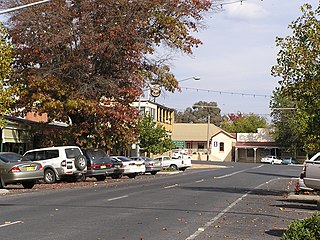
Bungendore is a town in the Queanbeyan Region of New South Wales, Australia, in Queanbeyan-Palerang Regional Council. It is on the Kings Highway near Lake George, the Molonglo River Valley and the Australian Capital Territory border. It has become a major tourist centre in recent years, popular with visitors from Canberra and some of it has heritage protection. It has expanded rapidly in recent years as a dormitory town of Canberra.

Araluen is a small town near Braidwood in the Southern Tablelands of New South Wales, Australia, in Queanbeyan-Palerang Regional Council. It lies in the valley of Araluen Creek, that joins the Deua River at roughly the midpoint in its course. At the 2021 census, Araluen had a population of 209 people.

Jugiong is a locality and town on the banks of the Murrumbidgee River near its confluence with Jugiong Creek. in the Hilltops Council Local Government area, New South Wales, Australia. It is situated just off the Hume Highway, by road, about 30 kilometres southwest from Bookham and 40 kilometres northeast from Gundagai.
Jerrabomberra Creek, a partly perennial stream of the Murrumbidgee catchment within the Murray–Darling basin, is located in the Capital Country region spanning both New South Wales and the Australian Capital Territory, Australia.

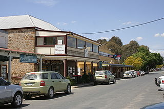
Majors Creek is a small village in the Southern Tablelands region of New South Wales, Australia. The nearest major town is Braidwood, 16 km (9.9 mi) to the north. At the 2021 census, the population of Majors Creek was 290. A former gold mining town, the settlement is today associated with the operational Dargues Reef gold mine. The name, Majors Creek is also applied to the surrounding area, for postal and statistical purposes.
Reedy Creek, an urban watercourse that is part of the Hawkesbury-Nepean catchment, is located in Greater Western Sydney, New South Wales, Australia.

Hoskinstown is a locality in Queanbeyan-Palerang Regional Council, New South Wales, Australia. The locality, and what remains of the cluster of settlement of the same name, is 38 km southeast of Canberra the Capital city of Australia, and 299 km southwest of Sydney. At the 2021 census, it had a population of 191.
The Happy Jacks Creek, a perennial river that is part of the Murrumbidgee catchment within the Murray–Darling basin, is located in the Snowy Mountains region of New South Wales, Australia.
The Kindra Creek, a watercourse that is part of the Murrumbidgee catchment within the Murray–Darling basin, is located in the Riverina and South West Slopes regions of New South Wales, Australia.
Rock Flat Creek is a watercourse that is part of the Murrumbidgee catchment within the Murray–Darling basin. It is located in the Monaro region of New South Wales, Australia.

Colinton is a locality in the Snowy Monaro Region, New South Wales, Australia. At the 2016 census, it had a population of 127. There was once a village and railway station of the same name.

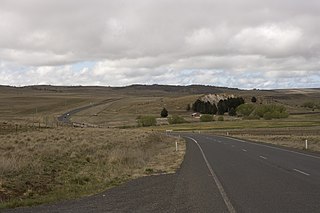
Bunyan is a locality in the Snowy Monaro Region, New South Wales, Australia. It lies on the eastern side of the Murrumbidgee River and on both sides of the Monaro Highway about 110 km south of Canberra and about 10 km north of Cooma. At the 2016 census, it had a population of 152.

Monga is a locality in the Queanbeyan-Palerang Region, Southern Tablelands, New South Wales, Australia. It lies on the Kings Highway at the top of the Clyde Mountain, about 110 km east of Canberra and 22 km southeast of Braidwood. A large part of the locality forms part of the Monga National Park. At the 2016 census, it had a population of 14.

Merrill is a locality in the Upper Lachlan Shire, New South Wales, Australia. It lies on Merrill Creek, to the west of the road from Gunning to Crookwell, about 15 km north of Gunning and 80 km north of Canberra. At the 2016 census, it had a population of 31.
Numeralla, is a village in Snowy Monaro Region of New South Wales, Australia. The name is also applied to the surrounding area, for postal and statistical purposes. In 2016, the population of the village and its surrounding area was 258. The village was known as Umaralla until 1972.
Lost River is a locality, in the Upper Lachlan Shire, within the Southern Tablelands of New South Wales, Australia. It lies on either side of the main road between Crookwell and Boorawa, which are the nearest towns to it.


