Kings Highway (Australia)

Last updated

Kings Highway

New South Wales
Location Kings Hwy.svg
General information
TypeHighway
Length139 km (86 mi) [1]
Gazetted August 1928 (NSW) [2]
Route number(s)
  • New South Wales alphanumeric route B52.svg B52 (2013–present)
    (Symonston–ACT/NSW border)
  • AUS Alphanumeric Route B52.svg B52 (2013–present)
    (NSW/ACT border–Batemans Bay)
Former
route number
Australian national route 52.svg National Route 52 (1974–2013)
Entire route
Major junctions
West endNew South Wales alphanumeric route A23.svg Canberra Avenue
Symonston, Australian Capital Territory
 
East endAUS Alphanumeric Route A1.svg Princes Highway
Batemans Bay, New South Wales
Location(s)
Major settlements Bungendore, Braidwood, Nelligen
Highway system

Kings Highway is an interstate highway located within the Australian Capital Territory and New South Wales, Australia. The highway connects Canberra with Batemans Bay on the South Coast. It is designated route B52.

Contents

Route

West to east, it starts at the interchange with Monaro Highway, Canberra Avenue and Ipswich Street on the northern border of Symonston in the Australian Capital Territory and continues in an easterly direction along Canberra Avenue, crosses over the border into New South Wales near Queanbeyan, passes through Queanbeyan itself, Carwoola, briefly crosses back into the Kowen district of ACT and then back into NSW heading south-east to Batemans Bay via Bungendore, Braidwood and Nelligen.

Kings Highway links Monaro Highway in Canberra to Princes Highway in Batemans Bay, and provides access for residents of Canberra to the NSW South Coast and its beaches. The highway is often busy on weekends, especially during summer. The highway also experiences a high number of car crashes, on occasions averaging around one every three days, costing the local community around the highway several million dollars a year. [3]

The landscape is generally sheep country. The highway travels from the Southern Tablelands to the South Coast via Clyde Mountain.

Notable features and landmarks

A small rock cave at "Pooh Bear's Corner" can be found near the top of the Clyde Mountain Pass. This was the location of a munitions store during the Second World War, that could be detonated to stop passage from the coast to the national capital inland. [4]

Dozens of soft toys are placed in the eucalyptus trees along the stretch of road that connects Queanbeyan and Bungendore. [5]

History

The road through the Clyde Mountain area was surveyed by Thomas Mitchell in 1855. [6]

A punt service across the Clyde River began at Nelligen in 1895 linking Batemans Bay to Braidwood. The service continued until 1964 when the Nelligen bridge was completed. [7] The new Nelligen Bridge is expected to open to traffic by late 2023 and the entire project, which includes intersection upgrades and demolition of the existing bridge, is scheduled for completion by late 2024. [8]

The passing of the Main Roads Act of 1924 [9] through the Parliament of New South Wales provided for the declaration of Main Roads, roads partially funded by the State government through the Main Roads Board (later the Department of Main Roads, and eventually Transport for NSW). Main Road No. 51 was declared along this road on 8 August 1928, from the intersection with Princes Highway at Batemans Bay, via Braidwood, Bungendore, and Queanbeyan to the border with the Federal Capital Territory (today the Australian Capital Territory); [2] with the passing of the Main Roads (Amendment) Act of 1929 [10] to provide for additional declarations of State Highways and Trunk Roads, this was amended to Trunk Road 51 on 8 April 1929.

The passing of the Roads Act of 1993 [11] through the Parliament of New South Wales updated road classifications and the way they could be declared within New South Wales. Under this act, the highway today retains its declaration as Main Road 51, from the state border with Australian Capital Territory west of Queanbeyan to the intersection with Princes Highway in Batemans Bay. [12] Despite its long-standing classification as a Main Road, and a long historical identity as Kings Highway, the road still has no officially gazetted name. Transport for NSW has come to an informal agreement with councils along the route to signpost the entire route as Kings Highway.

Kings Highway was signed National Route 52 across its entire length in 1974. With the conversion to the newer alphanumeric system in both states in 2013, this was replaced with route B52. [13] [14]

In 2006 construction commenced on Headquarters Joint Operations Command in the Kowen district of the ACT between Bungendore and Queanbeyan. The facility opened in December 2008, and sections of the highway between the HQJOC turnoff and Queanbeyan have progressively been upgraded to cater for the increased traffic. [15]

Road usage

In 2013 it was reported that the highway carries an average of 4,500 vehicles a day. There is an increase in traffic in the summer months. [16] In 2003, approximately 3,000 vehicles a day were using the highway at Nelligen. From Braidwood (at the Shoalhaven River Bridge) there were about 4,200 cars travelling on the road. Out of Bungendore near Burbong, 5,600 cars were counted each day. [17]

Casualty crash rates on the Kings Highway are 85% higher than the NSW average and road fatalities are 8% higher. A 2005 NRMA Motoring and Services road survey found: [3] [18]

Major intersections

State/TerritoryDistrict/LGALocationkm [1] miDestinationsNotes
Australian Capital Territory Canberra Central-Jerrabomberra boundary Fyshwick - Narrabundah - Symonston boundary0.00.0New South Wales alphanumeric route A23.svg Canberra Avenue (A23 northwest)  Capital Hill, Manuka Western terminus of Kings Highway, continues northwest as Canberra Avenue
New South Wales alphanumeric route A23.svg Monaro Highway (A23 south)  Hume , Cooma Southbound entrance and northbound exit only
Ipswich Street (northeast)  Fyshwick , to New South Wales alphanumeric route M23.svgWestern Australia MR-SM-11.svg Majura Parkway   Pialligo , Canberra Airport
Fyshwick-Symonston boundary1.30.81New South Wales alphanumeric route B52.svg Hindmarsh Drive (B52 west)  Woden
Newcastle Street (north)  Fyshwick
Route B52 continues west along Hindmarsh Drive
Jerrabomberra4.12.5Norse Road  Oaks Estate Westbound entrance and eastbound exit only
State border4.22.6Australian Capital Territory – New South Wales state border
New South Wales Queanbeyan Crestwood-Queanbeyan West boundary5.63.5Lanyon Drive  Cooma Roundabout with eastbound bypass lanes
Queanbeyan East 8.65.3Western Australia MR-SM-11.svg Yass Road (north)  Civic , Goulburn, Canberra Airport
Ellerton Drive (south)  Jerrabomberra
Roundabout
Palerang Carwoola 11.37.0Captains Flat Road  Captains Flat Roundabout with eastbound bypass lanes
State border16.610.3New South Wales – Australian Capital Territory state border
Australian Capital Territory Kowen Kowen 17.010.6Charcoal Kiln Road – Kowen
State border24.115.0Australian Capital Territory – New South Wales state border
New South Wales Palerang Bungendore 32.220.0Tarago Road  Tarago, Goulburn T-intersection
Manar 53.633.3Braidwood Road  Tarago, Goulburn
Braidwood 79.449.3Nerriga Road  Nerriga, Nowra
Eurobodalla Batemans Bay 139.086.4Peninsula Drive (south) – North Batemans Bay
AUS Alphanumeric Route A1.svg Princes Highway (A1)  Nowra, Bega, Wollongong, Sydney Eastern terminus of highway and route B52
1.000 mi = 1.609 km; 1.000 km = 0.621 mi

See also

Route map:

Template:Attached KML/Kings Highway, Australia
KML is from Wikidata

Related Research Articles

<span class="mw-page-title-main">Batemans Bay</span> Town in New South Wales, Australia

Batemans Bay is a town on the South Coast region of the state of New South Wales, Australia. Batemans Bay is administered by the Eurobodalla Shire council. The town is situated on the shores of an estuary formed where the Clyde River meets the southern Pacific Ocean.

<span class="mw-page-title-main">Newell Highway</span> Highway in New South Wales, Australia

Newell Highway is a national highway in New South Wales (NSW), Australia. It provides the major road link between southeastern Queensland and Victoria via central NSW and as such carries large amounts of freight. At 1,058 kilometres (657 mi) in length, the Newell is the longest highway in NSW, and passes through fifteen local government areas.

<span class="mw-page-title-main">Barton Highway</span>

Barton Highway is a highway in New South Wales and the Australian Capital Territory. It connects Canberra to Hume Highway at Yass, and it is part of the route from Melbourne to Canberra. It is named in honour of Sir Edmund Barton, the first Prime Minister of Australia.

<span class="mw-page-title-main">Eurobodalla Shire</span> Local government area in New South Wales, Australia

Eurobodalla Shire is a local government area located in the South Coast region of New South Wales, Australia. The Shire is located in a largely mountainous coastal region and situated adjacent to the Tasman Sea, the Princes Highway and the Kings Highway.

<span class="mw-page-title-main">Clyde River (New South Wales)</span> River in Australia

The Clyde River is an open intermediate tide dominated drowned valley estuary, or perennial river that flows into the Tasman Sea at Batemans Bay, located in the South Coast region of New South Wales, Australia.

<span class="mw-page-title-main">Braidwood, New South Wales</span> Town in New South Wales, Australia

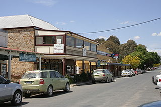
Braidwood is a town in the Southern Tablelands of New South Wales, Australia, in Queanbeyan–Palerang Regional Council. It is located on the Kings Highway linking Canberra with Batemans Bay. It is approximately 200 kilometres south west of Sydney, 60 kilometres inland from the coast, and 55 kilometres east of Canberra. Braidwood is a service town for the surrounding district which is based on sheep and cattle grazing, and forestry operations.

<span class="mw-page-title-main">Castlereagh Highway</span> Highway in New South Wales and Queensland, Australia

Castlereagh Highway is a 790-kilometre (490 mi) state highway located in New South Wales and Queensland, Australia. From north to south the highway traverses South West Queensland and the North West Slopes, Orana, and Central West regions of New South Wales.

<span class="mw-page-title-main">Tarago, New South Wales</span> Town in New South Wales, Australia

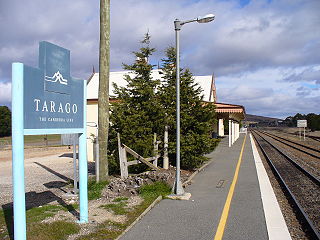
Tarago is a town in the Southern Tablelands of New South Wales, Australia in Goulburn Mulwaree Council. Part of the defined locality, which includes a large area of grazing country, is on the eastern shore of Lake George in the area of the Queanbeyan–Palerang Regional Council. The town is situated 39 kilometres south of the city of Goulburn and 69 kilometres northeast of Canberra, the capital city of Australia. It is located on the Goulburn-Braidwood road. The town is notable for recent renewable energy projects in the surrounding districts.

<span class="mw-page-title-main">Bungendore</span> Town in New South Wales, Australia

Bungendore is a town in the Queanbeyan Region of New South Wales, Australia, in Queanbeyan-Palerang Regional Council. It is on the Kings Highway near Lake George, the Molonglo River Valley and the Australian Capital Territory border. It has become a major tourist centre in recent years, popular with visitors from Canberra and some of it has heritage protection. It has expanded rapidly in recent years as a dormitory town of Canberra.

<span class="mw-page-title-main">South Coast (New South Wales)</span> Region in New South Wales, Australia

The South Coast refers to the narrow coastal belt from Shoalhaven district in the north to the border with Victoria in the south in the south-eastern part of the State of New South Wales, Australia. It is bordered to the west by the coastal escarpment of the Southern Tablelands, and is largely covered by a series of national parks, namely Jervis Bay National Park, Eurobodalla National Park, and Beowa National Park. To the east is the coastline of the Pacific Ocean, which is characterised by rolling farmlands, small towns and villages along a rocky coastline, interspersed by numerous beaches and lakes.

<span class="mw-page-title-main">Bombala railway line</span>

The Bombala railway line is a branch railway line in the south of New South Wales, Australia. The northern part of it forms part of the main line from Sydney to Canberra, but the southern part is closed. It branches off the Main South line at Joppa Junction, south of Goulburn. The line is used by NSW TrainLink Xplorer services running between Sydney Central and Canberra station.

<span class="mw-page-title-main">Lachlan Valley Way</span> Highway in New South Wales

Lachlan Valley Way is a New South Wales country road running from Booligal to north of Yass. It was named after the Lachlan River, and follows its southern bank for the majority of its length.

<span class="mw-page-title-main">Nelligen, New South Wales</span> Town in New South Wales, Australia

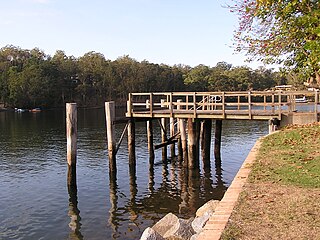
Nelligen is a village on the Clyde River on the South Coast of New South Wales, Australia. It is located on the Kings Highway.

<span class="mw-page-title-main">Clyde Mountain</span>

Clyde Mountain, at an elevation of 781 metres (2,562 ft) AHD , is a mountain in the Southern Tablelands region of New South Wales, Australia.

<span class="mw-page-title-main">Larbert, New South Wales</span> Town in New South Wales, Australia

Larbert is a locality in the Queanbeyan-Palerang Region of the Southern Tablelands region of New South Wales. It lies mostly north of the Kings Highway between Bungendore and Braidwood where it crosses the Shoalhaven River. At the 2021 census, it had a population of 34.

<span class="mw-page-title-main">Monga, New South Wales</span> Town in New South Wales, Australia

Monga is a locality in the Queanbeyan-Palerang Region, Southern Tablelands, New South Wales, Australia. It lies on the Kings Highway at the top of the Clyde Mountain, about 110 km east of Canberra and 22 km southeast of Braidwood. A large part of the locality forms part of the Monga National Park. At the 2016 census, it had a population of 14.

<span class="mw-page-title-main">The Wool Road</span> Historic road in New South Wales, Australia

The Wool Road was a historic road in New South Wales, Australia, that ran from Nerriga to what is now called Vincentia on Jervis Bay. It was constructed privately in 1841, using convict labour. Its purpose was to provide a shorter route to a seaport for wool grown at Braidwood and beyond. The historical significance of The Wool Road is that it was the first road, capable of being used by wheeled vehicles, linking the inland area around Braidwood to the South Coast. The road led to the foundation of the privately owned port town of South Huskisson and the adjacent 'government townshIp' of Huskisson.

<span class="mw-page-title-main">James Larmer</span>

James Larmer was a government surveyor in the colony of New South Wales. Between 1830 and 1859, he surveyed land, roads and settlements in New South Wales. He was an Assistant Surveyor to the Surveyor-General, Sir Thomas Mitchell, from 1835 to 1855. In 1835, he was second in command of Mitchell’s second expedition. He is also noteworthy for his recording of Aboriginal words from various parts of New South Wales.

Currowan is a locality in the Eurobodalla Shire, on the South Coast of New South Wales, Australia. At the 2016 census, it had a population of 53.

The Corn Trail was an early bridle track linking the Southern Tablelands to the coastal valley of the Buckenbowra River, in New South Wales, Australia. It was restored and reopened as a walking track in 1988.

References

  1. 1 2 Google (11 August 2022). "Kings Highway" (Map). Google Maps . Google. Retrieved 11 August 2022.
  2. 1 2 "Main Roads Act, 1924-1927". Government Gazette of the State of New South Wales. No. 110. 17 August 1928. pp. 3814–20. Archived from the original on 3 August 2022. Retrieved 1 August 2022 via National Library of Australia.
  3. 1 2 "Research highlights costly Kings Highway crashes". ABC News . Australia. 20 October 2005. Retrieved 19 May 2013.
  4. Dunn, Peter. "DEMOLITION OF OUR HARBOURS, AIRFIELDS, ROADS AND OTHER IMPORTANT INSTALLATIONS". www.ozatwar.com. Retrieved 20 May 2013.
  5. Harden, Fred (25 March 2004). "Bear Spotting" . Retrieved 19 May 2013.
  6. Cumpston, J.H.L. (2007) [1954]. Thomas Mitchell: Surveyor General and Explorer. Project Gutenberg of Australia eBook. eBook No.: 0700531h.html. The final evidence—lamentably too final—of his tendency to do everything himself was his personal presence, in his sixty-fourth year, at the survey of a road through that rugged Clyde Mountain region: work which might well have been entrusted to his surveyors. ... Having contracted a chill when supervising the survey of a road from Braidwood to Nelligen, he developed broncho-pneumonia and died at his home, "Carthona" at Darling Point on 5 October 1855, in his sixty-fourth year.
  7. "Brief history of Nelligen, Batemans Bay and the Clyde River on the Eurobodalla South Coast, NSW Australia". Clyde River Houseboats. Archived from the original on 15 December 2007. Retrieved 14 January 2008.
  8. "$148m NSW Nelligen Bridge Replacement project now under construction".
  9. State of New South Wales, An Act to provide for the better construction, maintenance, and financing of main roads; to provide for developmental roads; to constitute a Main Roads Board Archived 11 August 2022 at the Wayback Machine 10 November 1924
  10. State of New South Wales, An Act to amend the Main Roads Act, 1924-1927; to confer certain further powers upon the Main Roads Board; to amend the Local Government Act, 1919, and certain other Acts; to validate certain payments and other matters; and for purposes connected therewith. Archived 12 August 2022 at the Wayback Machine 8 April 1929
  11. State of New South Wales, An Act to make provision with respect to the roads of New South Wales; to repeal the State Roads Act 1986, the Crown and Other Roads Act 1990 and certain other enactments; and for other purposes. Archived 11 August 2022 at the Wayback Machine 10 November 1924
  12. Transport for NSW (August 2022). "Schedule of Classified Roads and Unclassified Regional Roads" (PDF). Government of New South Wales. Archived from the original (PDF) on 25 August 2022. Retrieved 1 August 2022.
  13. "Road number and name changes in NSW" (PDF). Roads & Maritime Services . Government of New South Wales. 2012. Archived from the original (PDF) on 25 March 2016. Retrieved 7 November 2016.
  14. "Guide Signs MIS 12" (PDF). ACT Government. April 2019. p. 13. Archived from the original (PDF) on 28 March 2020. Retrieved 9 November 2022.
  15. "Inquiry into the Provision of Facilities for Headquarters Joint Operations Command, NSW (Chapter 3)" (PDF). Joint Standing Committee on Public Works. Parliament of Australia. 2004. Archived from the original (PDF) on 11 April 2008. Retrieved 14 January 2008.
  16. "Kings Highway Route Safety Review" (PDF). New South Wales Government. March 2013.
  17. "Traffic Volume Data for Southern Region 2003: Annual Average Daily Traffic for MAIN ROAD NO.51 – BATEMANS BAY-QUEANBEYAN" (PDF). Traffic Management Branch. New South Wales Road Traffic Authority. 2004. pp. 14–15. Archived from the original (PDF) on 11 April 2008. Retrieved 5 February 2008.
  18. "Report on Southern NSW and ACT Roads" (PDF). NRMA Motoring and Services. Archived from the original (PDF) on 11 April 2008.