Sea Cliff Bridge

Last updated

Sea Cliff Bridge
Sea Cliff Bridge from air.jpg
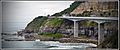
The Sea Cliff Bridge viewed from the air
Coordinates 34°15′14″S150°58′26″E / 34.25389°S 150.97389°E / -34.25389; 150.97389
Carries Lawrence Hargrave Drive
(also known as Grand Pacific Drive)
CrossesRockface on the Illawarra escarpment/Tasman Sea
Locale Coalcliff, New South Wales, Australia
BeginsCoalcliff
Ends Clifton
Other name(s)Lawrence Hargrave Drive Bridge
Owner Transport for NSW
Characteristics
Design
  1. Balanced off-shore parallel-to-coast cantilever bridge
    (Sea Cliff Bridge)
  2. Incremental launching girder bridge
    (Lawrence Hargrave Drive Bridge)
MaterialSteel reinforced concrete
Total length
  1. 455.6 metres (1,495 ft)
    (Sea Cliff Bridge)
  2. 210 metres (690 ft)
    (Lawrence Hargrave Drive Bridge)
Width6.3 metres (21 ft) at its widest point
Height41 metres (135 ft) at highest point
Longest span
  1. 3 x 10⁸ metres (354 ft)
    (Sea Cliff Bridge)
  2. 5 x 31 metres (102 ft)
    (Lawrence Hargrave Drive Bridge)
No. of spans
  1. 5 (Sea Cliff Bridge)
  2. 7 (Lawrence Hargrave Drive Bridge)
No. of lanes 2
History
Contracted lead designerMaunsell Australia
Engineering design byCoffey Geosciences
Constructed by Barclay Mowlem [1]
Construction end9 December 2005 (2005-12-09)
Construction costA$52 million
Inaugurated11 December 2005 (2005-12-11) by
Morris Iemma, NSW Premier
Location
Sea Cliff Bridge
References
[2] [3] [4]

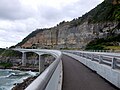
The Sea Cliff Bridge, together with the adjoining Lawrence Hargrave Drive Bridge, are two road bridges that carry the scenic Lawrence Hargrave Drive across the rockface on the Illawarra escarpment, located in the northern Illawarra region of New South Wales, Australia. The balanced cantilever and incremental launching girder bridges link the coastal villages of Coalcliff and Clifton and carry two lanes of traffic, and a pedestrian walkway.

Contents

The Sea Cliff Bridge was named by Makenzie Russell, who at the time was an eleven-year-old student, following a naming competition opened to local primary school students. [5] The Lawrence Hargrave Drive Bridge and the Lawrence Hargrave Drive are named in honour of Lawrence Hargrave, an Australian engineer, explorer, astronomer, inventor and aeronautical pioneer.

History

The Sea Cliff Bridge replaced a section of Lawrence Hargrave Drive that was permanently closed in August 2003 due to regular rock falls. A public outcry emerged over the road closure as Lawrence Hargrave Drive is the only road directly linking Coalcliff, Stanwell Park, Otford and Helensburgh to the northern suburbs of Wollongong. [6]

Description

The A$52 million 450-metre-long (1,476 ft) bridges brace against the Tasman Sea, up to 70 metres (230 ft) east of the original alignment of Lawrence Hargrave Drive. Completed in 2005, the Sea Cliff Bridge structure comprises a haunched box girder composed of prestressed concrete that was constructed using the balanced cantilever method, with five spans. [3] Adjoining the Sea Cliff Bridge is the 210-metre-long (689 ft) Lawrence Hargrave Drive Bridge  often not considered as two separate bridges. This latter girder bridge that was constructed using the incremental launching method, with seven spans, ranging from 24 to 31 metres (79 to 102 ft), shares a common pier with the Sea Cliff Bridge. [4]

The bridges incorporate two traffic lanes of 3.5 to 3.8 metres (11 to 12 ft) and a 2.5-metre (8 ft) pedestrian pathway. [7] Cyclists are allowed to use the traffic lanes and there are shoulders on either side of the road of approximately 1.2 metres (4 ft) width.

The bridges were officially opened by the NSW Premier Morris Iemma on 11 December 2005, and were met with public approval and increased business for the area's tourism industry. [6]

The bridges sit in a harsh marine environment as it directly faces the open ocean and is affected by high sea swell splashing. It is well attested that concrete structures in such environments are especially susceptible to chloride induced corrosion of the steel reinforcement, which can eventually lead to expensive repair works and significantly decrease the life of the structure. [8] [9]

Tourism

An hour south of Sydney, the bridges have been a major tourist spot since they opened in 2005. [10] The area adjacent to the bridges feature a scenic walkway surrounded by rocky cliffs [8] that is a popular location for love padlocks. [11]

Pioneer Walks published the route to the lookout and encouraged spectators to participate in an "unofficial walk with no safety precautions in place". [12] On 30 September 2018, a 24-year-old man hiked to the “lookout" atop the cliff overlooking the bridges, where he sat down to take a rest. The ground he sat on was loose, and he slid 20 metres (70 ft) to the cliff’s edge, where he then plummeted 40 metres (130 ft) to his death. [13]

Sea Cliff Bridge in May 2020 The Seacliff Bridge Grand Pacific Drive, New South Wales, Australia at Sunrise. May 2020.jpg
Sea Cliff Bridge in May 2020

The Sea Cliff Bridge and adjoining Lawrence Hargrave Drive Bridge were featured in a range of media including:

See also

Related Research Articles

<span class="mw-page-title-main">Sir Leo Hielscher Bridges</span> Bridges in Queensland, Australia

The Sir Leo Hielscher Bridges, formerly and still commonly known as the Gateway Bridge, are a side-by-side pair of road bridges on the Gateway Motorway (M1), which skirts the eastern suburbs of Brisbane, Queensland, Australia. The western bridge carries traffic to the north and the eastern bridge carries traffic to the south. They are the most eastern crossings of the Brisbane River and the closest to Moreton Bay, crossing at the Quarries Reach and linking the suburbs of Eagle Farm and Murarrie. The original western bridge was opened on 11 January 1986 and cost A$92 million to build. The duplicate bridge was opened in May 2010, and cost $350 million.

<span class="mw-page-title-main">Wollongong</span> City in New South Wales, Australia

Wollongong, colloquially referred to as The Gong, is a city located in the Illawarra region of New South Wales, Australia. The name is believed to originate from the Dharawal language, meaning either 'five islands/clouds', 'ground near water' or 'sound of the sea'. Wollongong lies on the narrow coastal strip between the Illawarra Escarpment and the Pacific Ocean, 85 kilometres south of central Sydney. Wollongong had an estimated urban population of 302,739 at June 2018, making it the third-largest city in New South Wales after Sydney and Newcastle and the tenth-largest city in Australia by population. The city's current Lord Mayor is Gordon Bradbery AM who was elected in 2021.

<span class="mw-page-title-main">Mount Keira</span> Suburb of Wollongong, New South Wales, Australia

Mount Keira is a suburb and mountain in the Illawarra region of New South Wales, Australia.

<span class="mw-page-title-main">Stanwell Park, New South Wales</span> Suburb of Wollongong, New South Wales, Australia

Stanwell Park is a coastal village and northern suburb of Wollongong, New South Wales, Australia. It is the northernmost point of the Illawarra coastal strip and lies south of Sydney's Royal National Park. It is situated in a small valley between Bald Hill to the north, Stanwell Tops to the west and Mount Mitchell to the south. It has two lagoons from the village's two creeks, Stanwell and Hargrave Creeks and a beach running between headlands. Stanwell Park and the surrounding suburbs are colloquially referred to by its postcode 2508.

<span class="mw-page-title-main">Bolte Bridge</span> Bridge in Melbourne, Australia

The Bolte Bridge is a large twin cantilever road bridge in Melbourne, Victoria, Australia. The Bolte Bridge carries a total of eight lanes of traffic – four lanes northbound and four lanes southbound. While officially only 490 metres in length, the actual structure appears much longer as it forms part of a 5 kilometre elevated roadway between Flemington Road and the West Gate Freeway. It spans the Yarra River and Victoria Harbour in the Docklands precinct to the west of the Melbourne CBD. It forms part of the CityLink system of toll roads that connects the Tullamarine Freeway from the northern suburbs with the West Gate Freeway and the Domain and Burnley tunnels to the Monash Freeway and the south eastern suburbs. It is named after Victoria's 38th and longest-serving Premier, Sir Henry Bolte.

<span class="mw-page-title-main">Bald Hill (Australia)</span> Hill on the Illawarra Range, New South Wales, Australia

Bald Hill is a hill on the Illawarra Range, in the state of New South Wales, Australia. With an elevation of approximately 180 metres (590 ft) AMSL, Bald Hill is one of the best known and most popular lookouts in the Illawarra region providing panoramic vistas across the Illawarra escarpment and over the Illawarra plain and the Tasman Sea of the South Pacific Ocean.

<span class="mw-page-title-main">Illawarra escarpment</span> Mountain range in New South Wales, Australia

The Illawarra escarpment, or officially the Illawarra Range, is the fold-created cliffs and plateau-eroded outcrop mountain range west of the Illawarra coastal plain south of Sydney, in the state of New South Wales, Australia. The range encloses the Illawarra region which stretches from Stanwell Park in the north to Kiama, Gerringong and the Shoalhaven River in the south.

<span class="mw-page-title-main">Iron Cove Bridge</span> Bridge in New South Wales, Australia

The Iron Cove Bridge is a heritage-listed road bridge that carries Victoria Road (A40) across Iron Cove, between the Sydney suburbs of Drummoyne and Rozelle. Iron Cove is an arm of Sydney Harbour.

<span class="mw-page-title-main">Lawrence Hargrave Drive</span> Road in New South Wales, Australia

Lawrence Hargrave Drive, part of the Grand Pacific Drive, is a scenic coastal road and popular tourist drive connecting the northernmost suburbs of Wollongong, New South Wales, Australia, to Wollongong, in the south, and Sydney, in the north across the scenic Sea Cliff Bridges. It was named after Lawrence Hargrave, an Australian aviation pioneer who lived nearby.

<span class="mw-page-title-main">Coalcliff, New South Wales</span> Suburb of Wollongong, New South Wales, Australia

Coalcliff is a town on the coast of New South Wales, Australia, between Sydney and Wollongong.

<span class="mw-page-title-main">Mount Henry Bridge</span> Bridge in Perth, Western Australia

The Mount Henry Bridge carries the Kwinana Freeway and Mandurah railway line over the Canning River in Perth, approximately 10 kilometres (6.2 mi) south of the Perth central business district. At 688 metres (2,257 ft) in length including abutments, it is the longest road bridge in Western Australia. It spans the river between the Mount Henry Peninsula and the suburb of Mount Pleasant.

<span class="mw-page-title-main">Clifton, New South Wales</span> Suburb of Wollongong, New South Wales, Australia

Clifton is a village on the coast of New South Wales, Australia, between Sydney and Wollongong. Along with nearby Coalcliff, the village began life as a coal-mining centre. It is situated on a narrow area between the sea and the Illawarra escarpment. The electrified South Coast railway line passes through, but the station at Clifton was closed in 1915. It reopened on 1934-07-04 and closed for the last time on 1983-11-27, at the time of double tracking and electrification.

<span class="mw-page-title-main">Austinmer, New South Wales</span> Suburb of Wollongong, New South Wales, Australia

Austinmer is a northern village of Wollongong on the south coast of New South Wales, Australia. It sits in the northern Illawarra region, south of Stanwell Park and immediately north of Thirroul.

<span class="mw-page-title-main">Mooney Mooney Bridge</span> Bridge in New South Wales, Australia

The Mooney Mooney Bridge, officially the Mooney Mooney Creek Bridge, and popularly known as The NSW Big Dipper Bridge, is a twin cantilever bridge that carries the Pacific Motorway (M1) across Mooney Mooney Creek, located near Mooney Mooney in the Brisbane Water National Park on the Central Coast of New South Wales, Australia. The concrete box girder bridge was opened on 14 December 1986 by the Prime Minister of Australia, Bob Hawke, and is owned and maintained by Transport for NSW, an agency of the Government of New South Wales.

<span class="mw-page-title-main">Bulli Pass</span>

Bulli Pass is a mountain pass with an elevation of 283 metres (928 ft) AHD  located northwest of Bulli, New South Wales, Australia. It is situated on the Illawarra escarpment west of the Illawarra coastal plain. It was built during the 19th century for use by loggers and locals transporting goods to and from Sydney. Beforehand sea travel was the only reliable method.

<span class="mw-page-title-main">Geography of Wollongong</span>

The city of Wollongong has a distinct geography. It lies on a narrow coastal plain flanked by the Pacific Ocean to the east and a steep sandstone precipice known as the Illawarra Escarpment to the west, most notably Mount Keira, joined to the escarpment by a high saddle.

<span class="mw-page-title-main">Meghna Bridge</span> Bridge in Bangladesh

Meghna Bridge is a road bridge in Bangladesh. It was built with the assistance of Japan and officially named Japan Bangladesh Friendship Bridge 1, but it is popularly known as Meghna Bridge. According to a study conducted in 2004 by the Embassy of Japan in Bangladesh, residents living around the Meghna Bridge recognized several positive impacts after the construction of the bridge.

<span class="mw-page-title-main">Incremental launch</span> Bridge building method

Incremental launch is a method in civil engineering of building a complete bridge deck from one abutment of the bridge only, manufacturing the superstructure of the bridge by sections to the other side. In current applications, the method is highly mechanised and uses pre-stressed concrete.

<span class="mw-page-title-main">Yowaka River bridge, Greigs Flat</span> Bridge in New South Wales, Australia

The Yowaka River bridge is a heritage-listed road bridge that carries the Princes Highway across the Yowaka River at Greigs Flat, New South Wales, Australia. It was built in 1936. The bridge is also known as the Yowaka Bridge near Eden. The bridge is owned by Transport for NSW. It was added to the New South Wales State Heritage Register on 20 June 2000.

<span class="mw-page-title-main">Hay Bridge, New South Wales</span> Bridge in New South Wales, Australia

The Hay Bridge is a road bridge that carries the Cobb Highway across the Murrumbidgee River at Hay, New South Wales, Australia. The current bridge is the second bridge located in Hay that crosses the Murrumbidgee; the first bridge was in operation from 1873 until 1973; the second and current bridge has operated since 1973.

References

  1. $10 million fix for Sea Cliff Bridge Illawarra Mercury 10 July 2012
  2. "Bridge Construction Statistics". Sea Cliff Bridge. Archived from the original on 12 September 2009. Retrieved 23 May 2009.
  3. 1 2 Sea Cliff Bridge at Structurae . Retrieved 8 April 2020.
  4. 1 2 Lawrence Hargrave Drive Bridge at Structurae . Retrieved 8 April 2020.
  5. "Makenzie who?". Sea Cliff Bridge. Archived from the original on 6 March 2016. Retrieved 2 February 2013.
  6. 1 2 "Why Was It Constructed?". Sea Cliff Bridge. Archived from the original on 8 December 2009. Retrieved 23 May 2009.
  7. "Sea Cliff Bridge". Projects. Boral. n.d. Retrieved 8 April 2020.
  8. 1 2 "APPLICATION OF CATHODIC PREVENTION TO SEA CLIFF BRIDGE, LAWRENCE HARGRAVE DRIVE" (PDF). Retrieved 3 October 2018.
  9. Sinclair, M. R (2005). "Lawrence Hargrave Drive balanced cantilever and incremental launch bridges construction". Concrete (5).
  10. "Sea Cliff Bridge". Destination Wollongong. 2020. Retrieved 8 April 2020.
  11. Minus, Jodie (13 March 2009). "Sea Cliff Bridge holds key to love". Illawarra Mercury . Retrieved 1 September 2011.
  12. "Sea Cliff Bridge". Pioneer Walks.
  13. Humphries, Glen (5 February 2019). "Bushwalking site promotes the deadly Sea Cliff Bridge walk". Illawarra Mercury . Retrieved 8 April 2020.
  14. "Shell Ferrari Advert". YouTube .
  15. "VE Holden Commodore SIDI - 900Km Ad". YouTube .
  16. "Forza Horizon 3 - All 13 Beauty Spot Locations Guide". YouTube .
  17. "Guy Sebastian - Choir (Official)". YouTube .