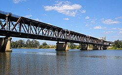
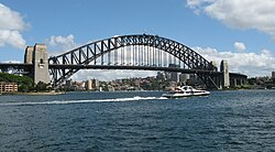
List of bridges in Australia

Last updated

Historical bridges

This table contains a non-exhaustive list of bridges listed on the various heritage registers of Australia.

Contents

#NameImage Heritage register LengthTypeCarries
Crosses
OpenedLocation State Notes
m ft
1 Richmond Bridge Richmond Bridge1.jpg Australian National Heritage
(Australia’s oldest surviving large stone arch bridge)
41135 Masonry
6 arches, sandstone
AUS Alphanumeric Route C351.svg Wellington Street
Coal River
1825 Richmond
42°44′01.9″S147°26′24.0″E / 42.733861°S 147.440000°E / -42.733861; 147.440000 (Richmond Bridge (Tasmania))
Tasmania [S 1]
[E 1]
[E 2]
2 Lennox Bridge 24 - Lennox Bridge (5045255b1).jpg (Now defunct)
Register of the National Estate
Masonry
1 arch
Road bridge
Mitchells Pass
Lapstone Creek
1833 Glenbrook
33°45′15.2″S150°37′56.6″E / 33.754222°S 150.632389°E / -33.754222; 150.632389 (Lennox Bridge, Glenbrook)
New South Wales [S 2]
3 Lansdowne Bridge Lansdowne Bridge Sunset.jpg (Now defunct)
Register of the National Estate
Masonry
1 arch, sandstone
Span: 33.5 m (110 ft)
1836 Lansvale
33°53′24.1″S150°58′01.5″E / 33.890028°S 150.967083°E / -33.890028; 150.967083 (Lansdowne Bridge)
New South Wales [S 3]
[E 3]
4 Ross Bridge Ross Bridge (4562385051).jpg (Now defunct)
Register of the National Estate
Masonry
3 arches
AUS Alphanumeric Route C305.svg Roseneath Road
Macquarie River
1836 Ross
41°01′50.7″S147°29′23.1″E / 41.030750°S 147.489750°E / -41.030750; 147.489750 (Ross Bridge)
Tasmania [S 4]
5 Red Bridge Red Bridge, Campbell Town, Tasmania (31655622323).jpg (Now defunct)
Register of the National Estate
(Australia’s oldest surviving brick arch bridge)
Masonry
3 arches, brick
1838 Campbell Town
41°55′58.7″S147°29′33.9″E / 41.932972°S 147.492750°E / -41.932972; 147.492750 (Red Bridge (Tasmania))
Tasmania [E 4]
6 Nepean River railway bridge Menangle Viaduct 3.jpg New South Wales State Heritage Register 145476 Beam bridge
Wrought iron
1863 Menangle
34°07′04.8″S150°44′37.1″E / 34.118000°S 150.743639°E / -34.118000; 150.743639 (Nepean River railway bridge, Menangle)
New South Wales [1]
7 Prince Alfred Bridge OldHumeHighway,GundagaiWoodenBridge.jpg New South Wales State Heritage Register
(First iron truss bridge to be built in New South Wales)
(Second-oldest metal truss bridge remaining in Australia)
9223,025 Truss
Wooden, iron
Murrumbidgee River and its floodplain
1867 Gundagai
35°04′28″S148°06′25″E / 35.0744°S 148.1069°E / -35.0744; 148.1069 (Prince Alfred Bridge, Gundagai)
New South Wales [2]
8 Dickabram Bridge Dickabram Bridge.jpg
Register of the National Estate
191627 Truss
Steel, wood
Miva Road
Mary River
1886 Miva - Theebine
25°57′14.5″S152°29′43.5″E / 25.954028°S 152.495417°E / -25.954028; 152.495417 (Dickabram Bridge)
Queensland [S 5]
[E 5]
9 Princes Bridge Melbourne city landscape (2190791586).jpg 120390 Arch
Cast iron
1888 Melbourne
Melbourne central business district - Southbank
37°49′09.3″S144°58′05.8″E / 37.819250°S 144.968278°E / -37.819250; 144.968278 (Princes Bridge)
Victoria [S 6]
10 Hampden Bridge Hampden Bridge 115 6318.jpg (Now defunct)
Register of the National Estate
77253 Suspension
Wooden truss deck, masonry pylons
1898 Kangaroo Valley
34°43′38.7″S150°31′15.2″E / 34.727417°S 150.520889°E / -34.727417; 150.520889 (Hampden Bridge, Kangaroo Valley)
New South Wales [S 7]
[E 6]
11 Pyrmont Bridge Pyrmont Bridge. Darling Harbour Sydney. (24299518314).jpg (Now defunct)
Register of the National Estate
3691,211 Truss
Steel
Swing bridge
Footbridge
Cockle Bay
1902 Sydney
Darling Harbour - Sydney central business district
33°52′14.0″S151°12′02.6″E / 33.870556°S 151.200722°E / -33.870556; 151.200722 (Pyrmont Bridge)
New South Wales [S 8]
[E 7]
12 Noojee Trestle Bridge Noojee trestle.jpg Victorian Heritage Register
(Tallest surviving trestle bridge in Victoria)
102335 Trestle
Wood
Noojee railway line
(closed line)
1919 Noojee
37°54′01.9″S145°59′03.6″E / 37.900528°S 145.984333°E / -37.900528; 145.984333 (Noojee trestle bridge)
Victoria [3]
13 Maribyrnong River Viaduct Maribyrnong River viaduct bridge.jpg Victorian Heritage Register 3831,257 Trestle
Steel
1929 Melbourne
Sunshine North - Keilor East
37°44′50.4″S144°50′46.0″E / 37.747333°S 144.846111°E / -37.747333; 144.846111 (Maribyrnong River Viaduct)
Victoria [4]
14 William Jolly Bridge River views of Brisbane CBD seen from the top of 135 Coronation Drive, in March 2019, 10-3.jpg Queensland Heritage Register 5001,600 Arch
Concrete through arch
Australian state route 10.svg Grey Street
Brisbane River
1932 Brisbane
Brisbane central business district - South Brisbane
27°28′06.7″S153°00′55.9″E / 27.468528°S 153.015528°E / -27.468528; 153.015528 (William Jolly Bridge)
Queensland [S 9]
[5]
15 Grafton Bridge Graftonbridge1.jpg New South Wales State Heritage Register
(This bridge is a double-deck road/rail structure, the only one of its type in New South Wales. There is a lift span to allow passing of river traffic that is no longer in use.)
5251,722 Bascule Truss Bridge
Concrete
Steel
Bent Street
Clarence River
1932 Grafton
29°41′53″S152°56′32″E / 29.69806°S 152.94222°E / -29.69806; 152.94222 (Grafton Bridge)
New South Wales
[6]
[7]
16 McKillops Bridge McKillops Bridge and the Snowy River.jpg Victorian Heritage Register 255837 Truss
Concrete
Wood
McKillops Road
Snowy River
1936 Deddick Valley
37°5′01.7″S148°24′48.7″E / 37.083806°S 148.413528°E / -37.083806; 148.413528 (McKillops Bridge)
Victoria
[8]
[9]

Bridges of architectural interest

This table contains a non-exhaustive list of bridges of architectural interest, as determined by the Engineers Australia and/or other architectural organisations, as cited.

#NameImageArchitectural distinctionLengthTypeCarries
Crosses
OpenedLocation State Notes
m ft
1 Evan Walker Bridge Melbourne (AU), Evan Walker Bridge -- 2019 -- 1432.jpg Arch
Steel tied-arch

Span: 45 m (148 ft)
Footbrige
Yarra River
1992 Melbourne
Melbourne city centre - Southbank
37°49′10.6″S144°57′54.5″E / 37.819611°S 144.965139°E / -37.819611; 144.965139 (Evan Walker Bridge)
Victoria [S 10]
2 Jack Pesch Bridge Jack Pesch Bridge 02.JPG 243797 Cable-stayed
Steel truss deck, steel pylons

Span: 167 m (548 ft)
Footbridge
Brisbane River
1998 Brisbane
Indooroopilly - Chelmer
27°30′21.1″S152°58′27.2″E / 27.505861°S 152.974222°E / -27.505861; 152.974222 (Jack Pesch Bridge)
Queensland [S 11]
3 Goodwill Bridge River views of Goodwill Bridge and Captain Cook Bridge, seen from Emporium Hotel South Bank, Brisbane, January 2019.jpg 4501,480 Arch
Steel through arch

Span: 102 m (335 ft)
Footbridge
Brisbane River
2001 Brisbane
South Brisbane - Gardens Point
27°28′50.7″S153°01′37.0″E / 27.480750°S 153.026944°E / -27.480750; 153.026944 (Goodwill Bridge)
Queensland [S 12]
4 Webb Bridge  [ fr ] Webb bridge.jpg 225738 Bridge
Footbridge
Yarra River
2003 Melbourne
Docklands
37°49′23.8″S144°56′50.2″E / 37.823278°S 144.947278°E / -37.823278; 144.947278 (Webb Bridge)
Victoria [S 13]
[10]
5 Kurilpa Bridge Kurilpa Bridge and South Brisbane seen from level 10 of North Quay building, Brisbane.jpg Tensegrity bridge4251,394 Cable-stayed
Steel

Span: 135 m (443 ft)
Footbridge
Brisbane River
2009 Brisbane
Brisbane central business district - South Brisbane
27°28′09.7″S153°01′05.5″E / 27.469361°S 153.018194°E / -27.469361; 153.018194 (Kurilpa Bridge)
Queensland [S 14]
6 Seafarers Bridge Seafarers Bridge (21604529).jpeg Masonry
2 arches

Span: 75 m (246 ft)
Footbridge
Yarra River
2009 Melbourne
Docklands - South Wharf
37°49′25.3″S144°57′07.2″E / 37.823694°S 144.952000°E / -37.823694; 144.952000 (Seafarers Bridge)
Victoria [S 15]
7 Matagarup Bridge Serpent Bridge Take 2 (48884812366).jpg 3701,210 Arch
Steel through arch

Span: 160 m (520 ft)
Footbridge
Swan River
2018 Perth
31°57′16.2″S115°53′07.3″E / 31.954500°S 115.885361°E / -31.954500; 115.885361 (Matagarup Bridge)
Western Australia [S 16]
8 Neville Bonner Bridge
proposed
270890 Cable-stayed
Steel

Span: 145 m (476 ft)
Footbridge
Brisbane River
Brisbane
Brisbane central business district - South Brisbane
27°28′26.4″S153°01′20.2″E / 27.474000°S 153.022278°E / -27.474000; 153.022278 (Neville Bonner Bridge)
Queensland [11]

Major road and railway bridges

This table presents a non-exhaustive list of the road and railway bridges with spans greater than 100 metres (328 ft).

Image#NameSpanLengthTypeCarries
Crosses
OpenedLocation State Notes
m ft m ft
1 Sydney Harbour Bridge SydneyHarbourBridge1 gobeirne.jpg 5031,6501,1493,770 Arch
Steel through arch
1932 Sydney
Milsons Point - Dawes Point
33°51′07.4″S151°12′38.7″E / 33.852056°S 151.210750°E / -33.852056; 151.210750 (Sydney Harbour Bridge)
New South Wales [S 17]
[E 8]
2 Anzac Bridge 2019-04-10 ANZAC Bridge 2.jpg 3451,1326252,051 Cable-stayed
Concrete beam deck, concrete pylons
140+345+140
AUS Alphanumeric Route A4.svg Western Distributor
Johnstons Bay
1996 Sydney
Rozelle - Pyrmont
33°52′08.8″S151°11′08.6″E / 33.869111°S 151.185722°E / -33.869111; 151.185722 (Anzac Bridge)
New South Wales [Note 1]
[S 18]
3 Tasman Bridge Tasman Bridge, Hobart, Tasmania, Australia (April 2017).jpg 1,0003,300
(x21)
1,3964,580 Girder bridge
Prestressed concrete beam deck, concrete pylons
1964 Hobart
Queens Domain - Montagu Bay
42°51′54″S147°20′33″E / 42.86500°S 147.34250°E / -42.86500; 147.34250 (Tasman Bridge)
Tasmania
[S 19]
4 West Gate Bridge West Gate Bridge Melbourne.jpg 3361,1022,5828,471 Cable-stayed
Steel box girder deck, steel pylons
144+336+144
1978 Melbourne
Spotswood - Port Melbourne
37°49′48.0″S144°53′55.9″E / 37.830000°S 144.898861°E / -37.830000; 144.898861 (West Gate Bridge)
Victoria [S 20]
[12]
5 Gladesville Bridge Gladesville Bridge(2).jpg 3051,0014881,601 Arch
Concrete deck arch
1964 Sydney
Huntleys Point - Drummoyne
33°50′31.9″S151°08′52.3″E / 33.842194°S 151.147861°E / -33.842194; 151.147861 (Gladesville Bridge)
New South Wales [S 21]
[13]
6 Story Bridge Story Bridge, Brisbane - panoramio.jpg 2829257772,549 Cantilever
Steel
82+282+82
Australian state route 15.svg Bradfield Highway
Brisbane River
1940 Brisbane
Fortitude Valley - Kangaroo Point
27°27′49.0″S153°02′08.7″E / 27.463611°S 153.035750°E / -27.463611; 153.035750 (Story Bridge)
Queensland [S 22]
[E 9]
[14]
7 Sir Leo Hielscher Bridges GATEWAY BRIDGE 2007-2.jpg 2608501,6305,350 Box girder
Prestressed concrete
162+260+162
Twin bridges
1986
2010
Brisbane
Eagle Farm - Murarrie
27°26′43.0″S153°06′04.4″E / 27.445278°S 153.101222°E / -27.445278; 153.101222 (Sir Leo Hielscher Bridges)
Queensland [S 23]
[15]
8 Mooney Mooney Bridge Mooney Mooney Bridge from below.jpg 2207204851,591 Box girder
Prestressed concrete
134+220+130
Twin bridges
1986 Mooney Mooney Creek
33°25′56.8″S151°15′13.1″E / 33.432444°S 151.253639°E / -33.432444; 151.253639 (Mooney Mooney Bridge)
New South Wales [S 24]
[16]
9 Batman Bridge Tasmania - Batman Bridge.jpg 2157054321,417 Cable-stayed
Steel truss deck, inclined steel pylon
1968 Sidmouth - Hillwood
41°13′02.0″S146°54′52.6″E / 41.217222°S 146.914611°E / -41.217222; 146.914611 (Batman Bridge)
Tasmania [S 25]
10 Eleanor Schonell Bridge Eleanor Schonell Bridge, Brisbane2.jpg 1846045201,710 Cable-stayed
Composite steel/concrete deck, concrete pylons
30+73+184+73+30
2006 Brisbane
St Lucia - Dutton Park
27°29′51.9″S153°01′15.7″E / 27.497750°S 153.021028°E / -27.497750; 153.021028 (Eleanor Schonell Bridge)
Queensland [S 26]
[17]
11 Walter Taylor Bridge Indooroopilly bridges2.jpg 183600300980 Suspension
Steel truss deck, concrete pylons
Australian state route 20.svg Coonan Street
Brisbane River
1936 Brisbane
Indooroopilly - Chelmer
27°30′20.4″S152°58′25.1″E / 27.505667°S 152.973639°E / -27.505667; 152.973639 (Walter Taylor Bridge)
Queensland [S 27]
[E 10]
[18]
12 Rip Bridge Rip Bridge from the air.jpg 1836003301,080 Arch
Concrete arch deck
Maitland Bay Drive
Brisbane Water
Daleys Point - Blackwall
33°30′24.6″S151°20′48.1″E / 33.506833°S 151.346694°E / -33.506833; 151.346694 (Rip Bridge)
New South Wales [19]
[20]
13 Captain Cook Bridge Captain Cook Bridge 4.jpg 1836005551,821 Box girder
Prestressed concrete
73+183+146+110+73
Twin bridges
1972 Brisbane
Gardens Point - Kangaroo Point
27°28′51.3″S153°01′45.7″E / 27.480917°S 153.029361°E / -27.480917; 153.029361 (Captain Cook Bridge, Brisbane)
Queensland [S 28]
[21]
14 Bolte Bridge Boltebridge.jpg 173568
(x2)
4901,610 Box girder
Prestressed concrete
72+173+173+72
1999 Melbourne
Docklands - Port Melbourne
37°49′10.1″S144°55′56.1″E / 37.819472°S 144.932250°E / -37.819472; 144.932250 (Bolte Bridge)
Victoria [S 29]
[22]
15 Long Gully Bridge
dismantled in 1937
SLNSW 796752 Suspension Bridge North Sydney.jpg 152499 Suspension
Steel truss deck, masonry pylons
Strathallen Avenue
Sydney tram network
Flat Rock Creek
1892 Sydney
Northbridge - Cammeray
33°49′01.4″S151°12′44.5″E / 33.817056°S 151.212361°E / -33.817056; 151.212361 (Long Gully Suspension Bridge)
New South Wales [E 11]
16 Pheasants Nest Bridge 150490304997 Box girder
Prestressed concrete
77+150+77
Twin bridges
1980 Pheasants Nest
34°14′12.9″S150°39′44.3″E / 34.236917°S 150.662306°E / -34.236917; 150.662306 (Pheasants Nest Bridge)
New South Wales [S 30]
[23]
17 Victoria Bridge Victoria Bridge, Brisbane 04.jpg 1464793131,027 Box girder
Prestressed concrete
Melbourne Street - Queen Street
Brisbane River
1969 Brisbane
Brisbane CBD - South Brisbane
27°28′20.4″S153°01′16.3″E / 27.472333°S 153.021194°E / -27.472333; 153.021194 (Victoria Bridge, Brisbane)
Queensland [S 31]
[E 12]
18 Hawkesbury River railway bridge Hawkesbury River rail bridge.jpg 135443
(x2)
7852,575 Truss
Steel
135+106x4+135
1946 Cogra Bay - Brooklyn
33°32′01.5″S151°13′42.9″E / 33.533750°S 151.228583°E / -33.533750; 151.228583 (Hawkesbury River railway bridge)
New South Wales [E 13]
19 Peats Ferry Bridge Hawkesbury River road bridges.jpg 134440
(x2)
6112,005 Truss
Steel
43+134+134+90x8
1945 Mooney Mooney - Brooklyn
33°32′24.2″S151°11′56.2″E / 33.540056°S 151.198944°E / -33.540056; 151.198944 (Peats Ferry Bridge)
New South Wales [E 14]
[24]
20 Merivale Bridge River views of Brisbane CBD seen from the top of 135 Coronation Drive, in March 2019, 10-2.jpg, in March 2019, 10.jpg 1334367502,460 Arch
Steel tied-arch
1978 Brisbane
Brisbane CBD - South Brisbane
27°28′09.6″S153°00′47.1″E / 27.469333°S 153.013083°E / -27.469333; 153.013083 (Merivale Bridge)
Queensland [S 32]
21 Go Between Bridge Go between bridge.jpg 117384300980 Box girder
Prestressed concrete
80+117+74
Road bridge
Brisbane River
2010 Brisbane
Brisbane CBD - South Brisbane
27°28′11.3″N153°00′44.1″E / 27.469806°N 153.012250°E / 27.469806; 153.012250 (Go Between Bridge)
Queensland [S 33]
22 Bowen Bridge Bowen Bridge from W shore1.JPG 109358
(x8)
9763,202 Box girder
Prestressed concrete
56+109x8+48
1984 Hobart
42°49′03.1″S147°18′26.5″E / 42.817528°S 147.307361°E / -42.817528; 147.307361 (Bowen Bridge)
Tasmania [25]
23 Sea Cliff Bridge Sea Cliff Bridge from air.jpg 108354
(x3)
4551,493 Box girder
Prestressed concrete
62+108x3+61
2005 Clifton - Coalcliff
34°15′14.8″S150°58′24.5″E / 34.254111°S 150.973472°E / -34.254111; 150.973472 (Sea Cliff Bridge)
New South Wales [S 34]
[26]
24 Long Gully Bridge Long Gully Bridge, Northbridge.jpg 105344152499 Arch
Concrete deck arch
Strathallen Avenue
Flat Rock Creek
1939 Sydney
Northbridge - Cammeray
33°49′01.2″S151°12′44.5″E / 33.817000°S 151.212361°E / -33.817000; 151.212361 (Long Gully Bridge)
New South Wales [E 11]
25 Albert Bridge Albert Bridge, Brisbane 08.JPG 104341
(x2)
208682 Truss
Steel
104x2
1895 Brisbane
Indooroopilly - Chelmer
27°30′21.4″S152°58′26.5″E / 27.505944°S 152.974028°E / -27.505944; 152.974028 (Albert Bridge, Brisbane)
Queensland [S 35]
[E 15]
[27]
26 Indooroopilly Railway Bridge Indooroopilly Bridge.jpg 104341
(x2)
208682 Truss
Steel
104x2
1957 Brisbane
Indooroopilly - Chelmer
27°30′21.2″S152°58′25.9″E / 27.505889°S 152.973861°E / -27.505889; 152.973861 (Indooroopilly Railway Bridge)
Queensland [28]
27 Macleay Valley Bridge 3,20010,500 Beam
Prestressed concrete
94x34m
2013 Frederickton
31°02′10.5″S152°53′12.4″E / 31.036250°S 152.886778°E / -31.036250; 152.886778 (Macleay Valley Bridge)
New South Wales [29]
[30]
28 South Road Superway 2,8009,200 Box girder
Prestressed concrete
2014 Adelaide
Wingfield - Regency Park
34°50′59.2″S138°33′52.6″E / 34.849778°S 138.564611°E / -34.849778; 138.564611 (South Road Superway)
South Australia [31]
29 Houghton Highway Hornibrook april 2011 (171).jpg 2,7408,990 Beam
Prestressed concrete
Australian state route 26.svg State Road 26
Australian state route 27.svg State Road 27
Bramble Bay
1979 Brisbane
Brighton - Clontarf
27°16′29.3″S153°04′14.1″E / 27.274806°S 153.070583°E / -27.274806; 153.070583 (Houghton Highway)
Queensland [32]
30 Ted Smout Memorial Bridge HORNIBROOK FEBRUARY 2009- (15).jpg 2,7408,990 Beam
Prestressed concrete
78x35m
Australian state route 26.svg State Road 26
Australian state route 27.svg State Road 27
Bramble Bay
2010 Brisbane
Brighton - Clontarf
27°16′30.1″S153°04′15.6″E / 27.275028°S 153.071000°E / -27.275028; 153.071000 (Ted Smout Memorial Bridge)
Queensland [33]
31 Hornibrook Bridge
dismantled in 2011
HORNIBROOK FEBRUARY 2009- (120).jpg 2,6848,806 Beam
Wood, concrete piles
1935 Brisbane
Brighton - Clontarf
27°16′28.6″S153°04′12.8″E / 27.274611°S 153.070222°E / -27.274611; 153.070222 (Hornibrook Bridge)
Queensland [34]
[35]

Notes and references

  1. The length given only takes into account the main bridge, central span(s) and shore span(s), approach viaducts are not counted.
  1. "Menangle rail bridge over Nepean River". New South Wales State Heritage Register . Department of Planning & Environment. CC BY icon.svg Text is licensed by State of New South Wales (Department of Planning and Environment) under CC-BY 4.0 licence.
  2. "Prince Alfred Bridge - Iron Road Bridge". New South Wales State Heritage Register . Department of Planning & Environment. H02022. Retrieved 18 February 2020. CC BY icon.svg Text is licensed by State of New South Wales (Department of Planning and Environment) under CC-BY 4.0 licence.
  3. "Victorian Heritage Database : Rail Bridge, Noojee Trestle Bridge Trail". vhd.heritagecouncil.vic.gov.au.
  4. "Victorian Heritage Database : Rail Bridge (Albion Viaduct)". vhd.heritage.vic.gov.au.
  5. "Queensland Heritage Register : William Jolly Bridge". apps.des.qld.gov.au - Queensland Government.
  6. "Heritage NSW : Grafton Bridge".
  7. "Heritage NSW : Grafton Bridge".
  8. "Victorian Heritage Register : McKillops Bridge".
  9. "Heritage Victoria : McKillops Bridge".
  10. "Webb Bridge". architravel.com.
  11. "Neville Bonner Bridge Architectural and Engineering Statement in Response to EDQ Request" (PDF). edqdad.dsdip.qld.gov.au. 2017.
  12. Prade, Marcel Le pont "West Gate", à Melbourne sur la Yarra, p.290
  13. "Engineer biography: Guy Maunsell". engineering-timelines.com.
  14. Engineering heritage inner Brisbane: a walk / drive tour, p.27
  15. John Hart, John Connal. "300 year sustainability: The Second Gateway Bridge Brisbane" (PDF). conferenz.co.nz. Aecom. Archived from the original (PDF) on 12 February 2013.
  16. Prade, Marcel Le Mooney Mooney Bridge, sur la Mooney Creek, p.298
  17. "Steel framed way speeds Brizzie bridge build - Eleanor Schonell Bridge". steel.org.au. Steel Australia. March 2008.
  18. "Queensland Heritage Register : Walter Taylor Bridge". apps.des.qld.gov.au - Queensland Government.
  19. Prade, Marcel Le Rip Bridge, près de Brisbane, Route n°615 (1974), p.297
  20. Leonardo Fernández Troyano (2003). Bridge Engineering: A Global Perspective. Thomas Telford. p. 215. ISBN   9780727732156.
  21. Matthew Hourigan, Padra Moua, Matthew Fleet, Dr. Robert Heywood, John Spathonis. "Rectification of Captain Cook Bridge Bearings".{{cite web}}: CS1 maint: multiple names: authors list (link)
  22. "Bolte Bridge X-TEND Mesh Screens and Safety Barrier". ronstantensilearch.com.
  23. Prade, Marcel Les ponts jumeaux sur le Nepean, à Pheasants Nest, p.298
  24. Don Fraser (October 2004). "Nomination Report for the Peats Ferry Bridge Hawkesbury River, NSW as an Historic Engineering Marker" (PDF). Engineers Australia .
  25. PM opens new bridge in Tasmania Leighton Newsletter April 1984
  26. "Sea Cliff Bridge - Construction Statistics". seacliffbridge.com. Archived from the original on 12 September 2009.
  27. "Queensland Heritage Register : Albert Bridge". apps.des.qld.gov.au - Queensland Government.
  28. "Queensland's archives : Indooroopilly Railway Bridge Plans". archivessearch.qld.gov.au - Queensland Government.
  29. "Australia's longest bridge crosses the Macleay River in Northern NSW". arup.com.
  30. "Kempsey bypass open". ABC News .
  31. "Use the South Road Superway and save time northbound lanes to open on thursday night" (PDF). infrastructure.sa.gov.au. Archived from the original (PDF) on 7 May 2014.
  32. "Fact sheet 2 - The existing Houghton Highway bridge" (PDF). Department of Transport & Main Roads . June 2007. Archived from the original (PDF) on 3 October 2009.
  33. "Fact sheet 3 - The new Houghton Highway bridge" (PDF). Department of Transport & Main Roads. June 2007. Archived from the original (PDF) on 3 October 2009.
  34. "Hornibrook Highway Bridge". epa.qld.gov.au. Archived from the original on 30 September 2007.
  35. "Fact sheet 1 - History of the Hornibrook Highway bridge" (PDF). Department of Transport & Main Roads. June 2007. Archived from the original (PDF) on 3 October 2009.

See also

Map all coordinates using: OpenStreetMap

Further reading

Related Research Articles

<span class="mw-page-title-main">Albert Bridge, Brisbane</span> Bridge in Queensland, Australia

Albert Bridge is a heritage-listed railway bridge of steel truss design crossing the Brisbane River between Indooroopilly and Chelmer in the City of Brisbane, Queensland, Australia. It was designed by Henry Charles Stanley and built from 1894 to 1895 by John McCormick & Son as a replacement for an earlier bridge lost to flooding in 1893. Both bridges were named in honour of the Prince of Wales, Prince Albert. It was added to the Queensland Heritage Register on 21 October 1992.

<span class="mw-page-title-main">John Bradfield (engineer)</span> Australian engineer

John Job Crew Bradfield was an Australian engineer best known as the chief proponent of the Sydney Harbour Bridge, of which he oversaw both the design and construction. He worked for the New South Wales Department of Public Works from 1891 to 1933. He was the first recipient of an engineering doctorate from the University of Sydney, in 1924. Other notable projects with which he was associated include the Cataract Dam, the Burrinjuck Dam, and Brisbane's Story Bridge. The Harbour Bridge formed only one component of the City Circle, Bradfield's grand scheme for the railways of central Sydney, a modified version of which was completed after his death. He was also the designer of an unbuilt irrigation project known as the Bradfield Scheme, which proposed that remote areas of western Queensland and north-eastern South Australia could be made fertile by the diversion of rivers from North Queensland.

<span class="mw-page-title-main">West End, Queensland</span> Suburb of Brisbane, Queensland, Australia

West End is an inner southern suburb in the City of Brisbane, Queensland, Australia. In the 2016 census, West End had a population of 9,474 people.

<span class="mw-page-title-main">Indooroopilly, Queensland</span> Suburb of Brisbane, Queensland, Australia

Indooroopilly is a riverside suburb 7.8 kilometres (4.8 mi) south-west of the Brisbane CBD, Queensland, Australia. In the 2021 census, Indooroopilly had a population of 13,622 people.

<span class="mw-page-title-main">Chelmer, Queensland</span> Suburb of Brisbane, Queensland, Australia

Chelmer is a south-western suburb in the City of Brisbane, Queensland, Australia. In the 2016 census, Chelmer had a population of 2,998 people.

Australian non-residential architectural styles are a set of Australian architectural styles that apply to buildings used for purposes other than residence and have been around only since the first colonial government buildings of early European settlement of Australia in 1788.

<span class="mw-page-title-main">Somerset Region</span> Local government area in Queensland, Australia

The Somerset Region is a local government area located in the West Moreton region of South East Queensland, Australia, about 100 kilometres (62 mi) northwest of Brisbane and centred on the town of Esk. It was created in 2008 from a merger of the Shire of Esk and the Shire of Kilcoy. It is commonly known as the Brisbane Valley, due to the Brisbane River which courses through the region, although significant parts of the region lie outside the hydrological Brisbane Valley itself.

The Queensland Heritage Council is an independent statutory authority created by the Queensland Parliament under the Queensland Heritage Act 1992. The Council advises and reports to the Minister for Environment and the Great Barrier Reef and is supported by a secretariat provided by the Department of Environment and Science. It is also responsible for maintaining the Queensland Heritage Register.

<span class="mw-page-title-main">Dickabram Bridge</span> Heritage listed road and rail bridge in Queensland, Australia

Dickabram Bridge is a heritage-listed road-and-rail bridge over the Mary River between Miva and Theebine, both in the Gympie Region, Queensland, Australia. It was the major bridge on the Kingaroy railway line. It was designed by Henry Charles Stanley and built from 1885 to 1886 by Messrs Michael McDermott, Owens & Co. It is also known as Mary River Bridge (Miva). The bridge was registered on the former Register of the National Estate in 1988.

The Woolstore Precinct is a residential area in the suburb of Teneriffe in Brisbane, Australia. A former industrial and commercial area, it has undergone urban renewal with preservation and re-purposing of many buildings from the early 20th century. This renewal has been guided by neighbourhood plans formulated by Brisbane City Council, with advice from the Queensland Heritage Council.

Thomas Pye was an Australian architect. He worked for over 33 years in the Public Works Department in Queensland. Pye contributed significantly to major buildings including the completion of the Public Offices and Rockhampton Customs House, as well as the design for the Lands and Survey Offices. He was responsible for the heightened expectations which produced the best public buildings yet seen in Queensland.

<span class="mw-page-title-main">Tighnabruaich, Indooroopilly</span> Historic site in Queensland, Australia

Tighnabruaich is a heritage-listed villa at 203 Clarence Road, Indooroopilly, City of Brisbane, Queensland, Australia. It was designed by Francis Drummond Greville Stanley and built around 1889. It was added to the Queensland Heritage Register on 7 February 2005.

<span class="mw-page-title-main">Henry Charles Stanley</span>

Henry Charles Stanley (1840–1921) was the chief engineer of the railways in Queensland, Australia.

<span class="mw-page-title-main">Dotswood, Queensland</span> Suburb of Charters Towers Region, Queensland, Australia

Dotswood is a rural locality in the Charters Towers Region, Queensland, Australia. In the 2016 census Dotswood had a population of 101 people.

<span class="mw-page-title-main">Electoral district of Maiwar</span> State electoral district of Queensland, Australia

Maiwar is an electoral district of the Legislative Assembly in the Australian state of Queensland, incorporating the inner western suburbs of Brisbane. It was created in the 2017 redistribution, and was first contested at the 2017 Queensland state election. The name of the electorate is stated by the government as being based on an Aboriginal name for the Brisbane River, however it is not the name that the Turrbal people who lived in the Brisbane region had for the river. The Brisbane River forms the southern boundary of the electorate.

<span class="mw-page-title-main">Macquarie River railway bridge, Bathurst</span> Bridge in New South Wales, Australia

The Macquarie River railway bridge is a heritage-listed disused railway bridge across the Macquarie River that was previously located on the Main Western line in Bathurst in the Bathurst Region local government area of New South Wales, Australia. It was built in 1876. It is also known as Bathurst Rail Bridge over Macquarie River and Bathurst – Kelso Railway Bridge. The property is owned by Transport Asset Holding Entity, an agency of the Government of New South Wales. The bridge was added to the New South Wales State Heritage Register on 2 April 1999 and was added to the Register of the National Estate on 18 April 1989.

<span class="mw-page-title-main">Indooroopilly Silver Mine</span>

The Indooroopilly Silver Mine is a historic silver mine at Indooroopilly, Brisbane, Australia

Frank Cullen was an Australian architect, who designed over 200 churches, school, monasteries, convents and other church related buildings in Queensland and Northern New South Wales, Australia

The Boyne Burnett Inland Rail Trail is a recreational route for walkers, cyclists and horse riders from Taragoola to Gayndah. It uses the closed Gladstone to Monto and Mungar Junction to Monto railway corridors in Queensland, Australia.