Drummoyne sits on the peninsula between Iron Cove and Five Dock Bay. It is surrounded on three sides by the Parramatta River and, as such, has some of Sydney's best waterfront views. Drummoyne neighbours the similarly historic Five Dock and Abbotsford.
History
William Wright, a merchant, whaler and sealer, bought land in the northern part of the area in 1853. The property was bounded by present-day Lyons Road and Victoria Road.[3]
Drummoyne House was built in the Georgian Classical style. It was rectangular in plan with a hipped roof with a concave verandah across the entire front and returned along each side.[3] He named it Drummoyne Park after his family home at Drumoyne on Clyde in Scotland. In Gaelic, Drummoyne means flat topped ridge.[4]
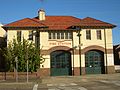
Heritage listings
Drummoyne has a number of heritage-listed sites, including:
In the 2021 census of population and Housing, the population of Drummoyne stood at 12,011 people, 52.8% were female and 47.2% were male, with a median age of 42 years. 66.9% of people were born in Australia. The most common countries of birth were England 4.0%, Italy 2.1%, New Zealand 2.1%, China 1.7%, and Greece 1.0%. 73.8% of people only spoke English at home. Other languages spoken at home included Italian 3.2%, Greek 3.0%, Mandarin 1.8%, Cantonese 1.5%, and Arabic 1.4%. The most common responses for religion in Drummoyne were No Religion 34.5%, Catholic 31.7% and Anglican 9.1%.[1]
Drummoyne's population is wealthier than the Australian average, with a median weekly household income of $2,776, compared with $1,746 in Australia. 67.5% of the suburbs occupied private dwellings were family households, 28.7% were lone person households and 3.8% were group households.[1]
Drummoyne is now part of the City of Canada Bay, a municipality formed in 2000 by the amalgamation of the municipalities of Drummoyne and Concord. It is part of the NSW Legislative Assembly electoral district of Drummoyne whose current member is Stephanie Di Pasqua MP. It is in the Federal electorate of Reid and is represented in Federal parliament by Sally Sitou.
Drummoyne is mostly residential with some commercial developments, and still retains some of its industrial heritage. The main shopping strip is located along Victoria Road and the intersecting Lyons Road featuring Australia's largest party store, The Party People as well as restaurants, home improvement stores and specialty shops. There is also a small shopping plaza at this point. The Birkenhead Point Outlet Centre, featuring a Coles supermarket, specialty shops and factory outlet stores is located at Birkenhead Point. The Canada Bay Civic Centre, the administration building for the City of Canada Bay, is located in Marlborough Street.
Sport
Drummoyne Rowing Club, formed in 1919, is one of four rowing clubs on Iron Cove in Sydney Harbour. It has occupied its current site at Sister's Bay, Drummoyne since its foundation.
Drummoyne is home to Drummoyne Oval, situated on the banks of the Parramatta River. In 1931, as a depression project, Drummoyne Oval was constructed on the site of a small oval which the Glebe and Balmain Rugby Union Clubs had used for junior matches since 1892. To ensure longevity of tenure, because there were not enough sporting grounds in Sydney, the Glebe Balmain Club decided to change its name to the Drummoyne District Rugby Football Club. It did so without giving up its long-held traditions, the scarlet jumpers of Glebe and its tag, "The Dirty Reds" and the black and gold of Balmain, colours still worn by today's players on their socks. The Drummoyne Rugby Club still plays at Drummoyne Oval as it has done for many years and is its permanent home.[9]
Drummoyne Olympic pool is located on the banks of Iron Cove. Filtered chlorine is separated from open water by 3 metres of poolside deck were Drummoyne Devils play.
The Bay Run is a popular route for runners and walkers.
This page is based on this Wikipedia article Text is available under the CC BY-SA 4.0 license; additional terms may apply. Images, videos and audio are available under their respective licenses.