Camperdown is an inner western suburb of Sydney, in the state of New South Wales, Australia. Camperdown is located 4 kilometres south-west of the Sydney central business district and is part of the Inner West region. Camperdown lies across the local government areas of the City of Sydney and Inner West Council.

Homebush Bay is a bay on the south bank of the Parramatta River, in the west of Sydney, Australia. The name is also sometimes used to refer to an area to the west and south of the bay itself, which was formerly an official suburb of Sydney, and has now become the suburbs of Sydney Olympic Park, Wentworth Point and part of the neighbouring suburb of Lidcombe, all part of the City of Parramatta. Homebush Bay is located 13 kilometres (8.1 mi) west of the Sydney central business district.

The Inner West of Sydney is an area directly west of the Sydney central business district, New South Wales, Australia. The suburbs that make up the Inner West are predominantly located along the southern shore of Port Jackson, stretching south to the shores of the Cooks River. The western boundary of the Inner West is approximately the A3 arterial road, which divides the Inner West from the Greater Western Sydney region. The Inner West is much larger than the Inner West Council local government area. The Inner West roughly corresponds with the Parish of Petersham and Parish of Concord, two cadastral divisions used for land titles.

Manly is a beach-side suburb of northern Sydney, in the state of New South Wales, Australia. It is 17 kilometres (11 mi) north-east of the Sydney central business district and is currently one of the three administrative centres of the local government area of Northern Beaches Council. Manly has a long-standing reputation as a tourist destination, owing to its attractive setting on the Pacific Ocean and easy accessibility by ferry.

The Division of Lowe was an Australian Electoral Division in the state of New South Wales. It was located in the inner western suburbs of Sydney, on the south shore of the Parramatta River. It included the suburbs of Drummoyne, Five Dock, Croydon, Croydon Park, Burwood, Enfield, Homebush, Strathfield, Concord, Rhodes, Canada Bay, Cabarita, Abbotsford and Mortlake.

Kissing Point is a point on the Parramatta River about 2 km south of Ryde, located in the suburb of Putney. Historically, the name referred to a much wider area than the current-day point; and perhaps originally to the point near Ryde Bridge where Settlers Park is now located, and where a 1948 brass plaque by the Council states.

Woolwich is a suburb on the Lower North Shore of Sydney, in the state of New South Wales, Australia. Woolwich is located 11 kilometres north-west of the Sydney central business district, in the local government area of the Municipality of Hunter's Hill. Woolwich sits on the peninsula between the Lane Cove River and the Parramatta River, jutting out from Hunters Hill.

Putney is a suburb of Northern Sydney, New South Wales, Australia. It is located 14 kilometres (9 mi) north-west of the Sydney central business district on the northern bank of the Parramatta River. Its local government area is the City of Ryde.
Mortlake is a suburb in the Inner West of Sydney, in the state of New South Wales, Australia. It is 10 kilometres west of the Sydney central business district, in the local government area of the City of Canada Bay.

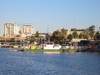
Meadowbank is a suburb of Sydney, New South Wales, Australia, 15 kilometres north west of the Sydney central business district, in the local government area of the City of Ryde and part of the Northern Sydney region. Meadowbank sits in a valley on the northern bank of the Parramatta River.
Concord is a suburb in the inner West of Sydney, in the state of New South Wales, Australia. It is 10 kilometres (6.2 mi) west of the Sydney central business district, in the local government area of the City of Canada Bay. Concord West is a separate suburb, to the north-west.

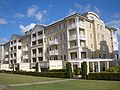
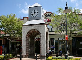
Breakfast Point is a suburb in the Inner West of Sydney, in the state of New South Wales, Australia. Breakfast Point is located 16 kilometres west of the Sydney central business district. It is in the local government area of the City of Canada Bay. People from Breakfast Point are colloquially called Breakfast Pointers.
Chiswick is a suburb in the Inner West of Sydney, in the state of New South Wales, Australia. It is located 9 kilometres west of the Sydney central business district in the local government area of the City of Canada Bay. Chiswick sits on the peninsula between Abbotsford Bay and Five Dock Bay, on the Parramatta River. It is surrounded by the suburbs of Abbotsford, Russell Lea and Drummoyne.

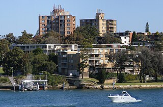
Henley is a suburb on the Lower North Shore of Sydney, in the state of New South Wales, Australia. Henley is located 9 kilometres west of the Sydney central business district, in the local government area of the Municipality of Hunter's Hill. Henley sits on the northern side of the Parramatta River.

Parramatta River ferry services connect suburbs along the Parramatta River in Sydney with Circular Quay by commuter ferry. The services are numbered F3 and form part of the Sydney Ferries network.

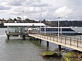
Cabarita ferry wharf is located on the southern side of the Parramatta River serving the Sydney suburb of Cabarita. It served by Sydney Ferries Parramatta River services operating between Circular Quay and Parramatta. The single wharf is served by RiverCat class ferries. The wharf was opened on 20 January 2000 in conjunction with improved transport services to Homebush Bay for the Sydney 2000 Olympic Games.

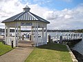
Bayview Park ferry wharf is a commuter wharf located in the Sydney suburb of Concord, New South Wales, on Hen & Chicken Bay. It is situated adjacent the namesake Bayview Park reserve, and upon the site of the historical Burwood ferry wharf, where Canadian exiles from the 19th century Lower Canada Rebellion landed in Sydney. Bayview Park was originally serviced by a Matilda Cruises route, before being included on Sydney Ferries' Parramatta River service in 2006, after a brief one-year service by Palm Beach Ferries. Services to the wharf were decommissioned by Sydney Ferries in October 2013, alongside Balmain West after patronage declined to a weekly average of 28 passengers. No operators currently service the wharf, although the structure still remains, with plans to return private ferry services to the wharf as part of a redevelopment project for a factory in eastern Concord.

Wentworth Point is a suburb of Sydney, in the state of New South Wales, Australia. It is located 13 kilometres west of the Sydney central business district, on the eastern edge of the local government area of City of Parramatta. It is on the western shore of Homebush Bay on the southern side of the Parramatta River. Wentworth Point is usually regarded as part of the Greater Western Sydney region, including in administrative contexts, but it is also regarded as part of the Inner West region of Sydney in some contexts, especially commercial contexts.

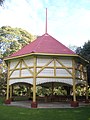
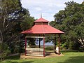
The Federation Pavilion was a temporary structure erected in Centennial Park, Sydney, for use in the celebrations marking the Federation of Australia on 1 January 1901. It was used to swear in the members of the first Federal Executive Council, including Australia's first governor-general and prime minister. The pavilion was originally covered in ornate plasterwork, but the exterior was not preserved and soon fell into disrepair. In 1903, the wooden framework was purchased by the Municipality of Concord and moved to Cabarita Park in the suburb of the Cabarita. The property is now owned by the City of Canada Bay, and was added to the New South Wales State Heritage Register on 22 December 2000. The pavilion has appeared in the clear panel of the Australian five-dollar note since 2016, when the new Next Generation Banknote series went into circulation.