Lilyfield, New South Wales

Last updated

Lilyfield
Sydney,  New South Wales
Lilyfield Leichhardt Park.JPG
Sensory Park in Leichhardt Park
Lilyfield, New South Wales
Map
Australia New South Wales location map blank.svg
Red pog.svg
Lilyfield
Coordinates 33°52′23″S151°9′58″E / 33.87306°S 151.16611°E / -33.87306; 151.16611
Population7,641 (SAL 2021) [1]
Postcode(s) 2040
Elevation37 m (121 ft)
Area2.2 km2 (0.8 sq mi)
Location6 km (4 mi) west of Sydney CBD
LGA(s) Inner West Council
State electorate(s) Balmain
Federal division(s) Grayndler
Suburbs around Lilyfield:
Rodd Point Drummoyne Rozelle
Haberfield Lilyfield Glebe
Annandale Leichhardt Forest Lodge

Lilyfield is a suburb in the Inner West [2] of Sydney, in the state of New South Wales, Australia. Lilyfield is located 6 kilometres west of the Sydney central business district, in the local government area of the Inner West Council.

Contents

Lilyfield is nestled in between the suburbs of Annandale, Rozelle and Leichhardt and is bounded to the west by Iron Cove. Originally a working-class area, today Lilyfield like many inner-city suburbs is becoming increasingly gentrified. Property investors, eager to capitalise on the suburb's proximity to the Sydney CBD, have purchased many of the original workers' cottages to renovate or develop.

History

Popular belief has it that the area was once farmland and was named for the lilies that reportedly grew in the fields. However, its name origin remains unclear. Lilyfield was originally part of the suburb of Leichhardt. [3]

Kirkbride complex, Callan Park hospital Mental hospital, calun park.jpg
Kirkbride complex, Callan Park hospital

The most dominant landmark in the area is the former Callan Park hospital. This was built on land acquired from the Callan Estates, a property between Balmain Road and Iron Cove. A psychiatric hospital was designed by James Barnet, the government architect, based on an asylum in Kent and utilising the principles of Dr Kirkbride, an American psychiatrist. [4] Completed in 1884, the hospital was known until 1914 as the Callan Park Hospital for the Insane; the main part of the hospital, a cluster of sandstone buildings, was called the Kirkbride complex.

More recently, the Kirkbride complex became the home of the Sydney College of the Arts, and the hospital functions were confined to the western buildings. This is now known as Rozelle Hospital. The Kirkbride complex is listed on the Register of the National Estate. [5]

After the construction of the City West Link Road in the 1990s, the suburb was effectively split into two parts. One half on the Rozelle side of the road, the other half on the Leichhardt side. This dramatic change in the geography did much to disrupt the sense of community in the relatively secluded suburb and almost led to its being subsumed into the neighbouring suburbs.

Orange Grove is a small locality within Lilyfield. Centred around Orange Grove Plaza, the locality shares its name with a primary school, market, and pub. The locality is served by the Inner West Light Rail.

Heritage listings

Lilyfield has a number of heritage-listed sites, including:

Demographics

Historical population
YearPop.±%
20016,945    
20066,761−2.6%
20117,342+8.6%
20167,616+3.7%
20217,641+0.3%

At the 2021 census the population of Lilyfield was 7,641. [10]

At the 2016 census, there were 7,616 people in Lilyfield. [11] The 2011 census of population shows there were 7,342 people in Lilyfield, with a median age of 38. [12] In the 2006 census there were 6,761 people in Lilyfield, [13] while in the 2001 census gives a total population of 6,945. [14]

Transport

A light rail maintenance facility on the site of the Rozelle Yards in 2017. The City West Link can be seen to the right. Lilyfield light rail stop is located below that road. Lilyfield's fairly close proximity to the Sydney CBD can be judged by the visibility of the Sydney CBD skyline in the background. Lilyfield maintenance centre.jpg
A light rail maintenance facility on the site of the Rozelle Yards in 2017. The City West Link can be seen to the right. Lilyfield light rail stop is located below that road. Lilyfield's fairly close proximity to the Sydney CBD can be judged by the visibility of the Sydney CBD skyline in the background.

Lilyfield station, in Catherine Street, is served by the Inner West Light Rail. The station opened in 2000, using a disused goods railway line from Central railway station. The stop was the western terminus of the light rail until 2014, when the line was extended along the route of another disused railway line to Dulwich Hill. Lilyfield was also the terminus of a tram line in the original Sydney tram system.

The 437 bus service runs from Lilyfield with no stops to the Sydney CBD with travel time of 7 minutes. The 470 bus service runs from Lilyfield to the Sydney CBD via Glebe, Broadway and Elizabeth Street. The 370 service runs from Leichhardt to Coogee via King Street, Newtown. The 440 service runs from Rozelle to Bondi Junction via Leichhardt, Camperdown and Paddington. The 445 services run from Balmain to Campsie railway station, via Norton Street. Route 447 includes a diversion to serve the Lilyfield light rail station.

The City West Link is a major arterial road, which is part of the A44 and crosses the Anzac Bridge. It provides an alternative route to Parramatta Road for the Sydney CBD from Ashfield.

Bicycle routes in Lilyfield include part of the regional east-west route from Parramatta to the Sydney CBD, along Lilyfield Road, the Bay Run path around Iron Cove, and the Whites Creek path, which provides a north-south route from Parramatta Road to The Crescent at White Bay.

Parks and recreation

Leichhardt Park, which includes the Leichhardt Park Aquatic Centre was originally part of Leichhardt, as was Leichhardt Oval. the home of the Wests Tigers/Balmain Tigers

Related Research Articles

<span class="mw-page-title-main">Camperdown, New South Wales</span> Suburb of Sydney, New South Wales, Australia

Camperdown is an inner western suburb of Sydney, in the state of New South Wales, Australia. Camperdown is located 4 kilometres south-west of the Sydney central business district and is part of the Inner West region. Camperdown lies across the local government areas of the City of Sydney and Inner West Council.

<span class="mw-page-title-main">Balmain, New South Wales</span> Suburb of Sydney, New South Wales, Australia

Balmain is a suburb in the Inner West of Sydney, New South Wales, Australia. Balmain is located 2 km (1.2 mi) west of the Sydney central business district, in the local government area of the Inner West Council.

<span class="mw-page-title-main">Leichhardt, New South Wales</span> Suburb of Sydney, New South Wales, Australia

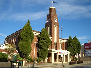
Leichhardt is a suburb in the Inner West of Sydney, in the state of New South Wales, Australia. Leichhardt is located 5 kilometres west of the Sydney central business district (CBD) and is the administrative centre for the local government area (LGA) of the Inner West Council. The suburb is bordered by Haberfield to the west, Annandale to the east, Lilyfield to the north and Petersham, Lewisham and Stanmore to the south.

<span class="mw-page-title-main">Glebe, New South Wales</span> Suburb of Sydney, New South Wales, Australia

Glebe is an inner-western suburb of Sydney in New South Wales. Glebe is located 3 kilometres (1.9 mi) southwest of the Sydney central business district and is part of the local government area of the City of Sydney, in the Inner West region.

<span class="mw-page-title-main">Lewisham, New South Wales</span> Suburb of Sydney, New South Wales, Australia

Lewisham is a suburb in the Inner West of Sydney, in the state of New South Wales, Australia. Lewisham is located 7 kilometres south-west of the Sydney central business district, in the local government area of Inner West Council. The postcode is 2049. Lewisham is surrounded by the suburbs of Petersham, Dulwich Hill, Summer Hill, Haberfield and Leichhardt.

<span class="mw-page-title-main">Rozelle</span> Suburb of Sydney, New South Wales, Australia

Rozelle is a suburb in the inner west of Sydney, in the state of New South Wales, Australia. It is located 4 kilometres west of the Sydney central business district, in the local government area of the Inner West Council.

<span class="mw-page-title-main">Sydney College of the Arts</span>

The Sydney College of the Arts (SCA) is a contemporary art school that was a faculty of the University of Sydney from 1990 until 2017, when it became a school of the Faculty of Arts and Social Sciences. Until the end of 2019, the campus was located in Rozelle, Sydney and housed within Callan Park in the Kirkbride complex, a cluster of sandstone buildings designed by James Barnet, the government architect, in the late 19th century. SCA moved to the main Camperdown Campus of the University of Sydney in 2020 and now occupies a substantial portion of the Old Teachers' College.

<span class="mw-page-title-main">Municipality of Leichhardt</span> Former local government area in New South Wales, Australia

The Municipality of Leichhardt was a local government area in the inner-west region of Sydney, New South Wales, Australia. It is about 10 kilometres (6.2 mi) west of the Sydney central business district. On 12 May 2016, Leichhardt merged with Marrickville Council and the Municipality of Ashfield to form the Inner West Council.

<span class="mw-page-title-main">Drummoyne</span> Suburb of Sydney, New South Wales, Australia

Drummoyne is a suburb in the Inner West of Sydney, in the state of New South Wales, Australia. Drummoyne is six kilometres west of the Sydney central business district and is the administrative centre for the local government area of the City of Canada Bay.

<span class="mw-page-title-main">Balmain East</span> Suburb of Sydney, New South Wales, Australia

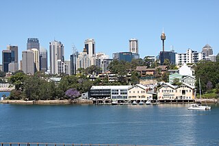
Balmain East is a suburb in the Inner West of Sydney, in the state of New South Wales, Australia. Balmain East is located three kilometres west of the Sydney central business district, in the local government area of the Inner West Council.

<span class="mw-page-title-main">Birchgrove, New South Wales</span> Suburb of Sydney, New South Wales, Australia

Birchgrove is a suburb in the Inner West of Sydney, in the state of New South Wales, Australia. Birchgrove is located five kilometres west of the Sydney central business district, in the local government area of the Inner West Council.

<span class="mw-page-title-main">Royal Oak Hotel</span> Australian pub in New South Wales, Australia

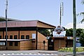
The Royal Oak Hotel is a pub located in Balmain, a suburb in the inner west region of Sydney, in the state of New South Wales, Australia. The pub has historical links with the union movement and is one of a number of buildings which formed an integral part of the shipbuilding and industrial history of the local area.

<span class="mw-page-title-main">Callan Park</span>

Callan Park, with the heritage listed name Callan Park Conservation Area & Buildings, is a 60-hectare (150-acre) heritage listed site in Lilyfield, a suburb in the Inner West Council in the Inner West of Sydney, in the state of New South Wales, Australia.

<span class="mw-page-title-main">Bald Rock Hotel</span> Australian pub in New South Wales, Australia

The Bald Rock Hotel is a heritage-listed pub in the suburb of Rozelle, overlooking White Bay in the inner west region of Sydney, in the state of New South Wales, Australia. It is the oldest continuously licensed hotel still operating in the Balmain and Rozelle area.

<span class="mw-page-title-main">Callan Park Hospital for the Insane</span> Former hospital in New South Wales, Australia

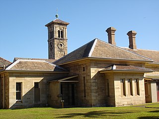
The Callan Park Hospital for the Insane (1878–1914) is a heritage-listed former insane asylum, which was subsequently, for a time, used as a college campus, located in the grounds of Callan Park, an area on the shores of Iron Cove in Lilyfield, a suburb of Sydney, New South Wales, Australia. In 1915, the facility was renamed as the Callan Park Mental Hospital and, again in 1976, to Callan Park Hospital. Since 1994, the facility has been formally known as Rozelle Hospital. In April 2008, all Rozelle Hospital services and patients were transferred to Concord Hospital. The Callan Park Act, 2002 (NSW) restricts future uses of the site to health, tertiary education and community uses.

<span class="mw-page-title-main">Annandale, New South Wales</span> Suburb of Sydney, New South Wales, Australia

Annandale is a suburb in the Inner West of Sydney, in the state of New South Wales, Australia. Annandale is located within 5 kilometres west of the Sydney central business district and is part of the local government area of the Inner West Council. Annandale's northern end lies on Rozelle Bay, which is on Sydney Harbour. Glebe lies to its east, Lilyfield and Leichhardt to its west and Stanmore and Camperdown to its south.
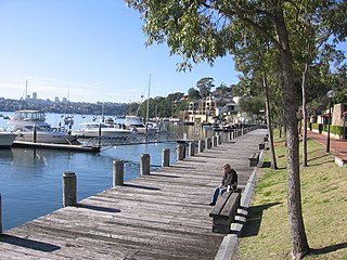
<span class="mw-page-title-main">The Bay Run</span>

<span class="mw-page-title-main">Inner West Light Rail</span> Light rail line in Sydney, New South Wales, Australia

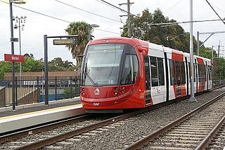
The Inner West Light Rail is a 12.8-kilometre (8.0 mi) light rail line in Sydney, New South Wales, Australia, running from Central railway station through the Inner West to Dulwich Hill and serving 23 stops. It is the original line of the Sydney light rail network, and was originally known as Sydney Light Rail. Light rail services on the line are now branded as the L1 Dulwich Hill Line.

<span class="mw-page-title-main">White's Creek Aqueduct</span> Heritage-listed sewage aqueduct in Sydney, Australia

White's Creek Aqueduct is a heritage-listed sewage aqueduct at Piper Street, Lilyfield, Inner West Council, Sydney, New South Wales, Australia. It was designed by engineer William Julius Baltzer of the New South Wales Public Works Department and built by the Department from 1897 to 1898. The property is owned by Sydney Water. It was added to the New South Wales State Heritage Register on 18 November 1999.

<span class="mw-page-title-main">Broughton Hall, Lilyfield</span> Historic site in New South Wales, Australia

Broughton Hall is a heritage-listed former residence, convalescent hospital and psychiatric clinic situated in Callan Park, which has its main entrance on Balmain Road, Lilyfield, Inner West Council, New South Wales, Australia. The house, Broughton House or Broughton Hall, was built c. 1841 and variously served as a residence for prominent businessmen and public figures (1841–1914). It is situated within the Callan Park Conservation Area, in Church Street, Lilyfield, near the corner of Wharf Road. It was used as No. 13 Australian Army Hospital during World War I. Other buildings were constructed over time and the precinct was used as the Broughton Hall Psychiatric Clinic (1921–1976). It was merged into Rozelle Hospital along with the adjacent Callan Park Hospital for the Insane in 1976, during which time it became the first premises for the Rivendell Child, Adolescent and Family Unit. Broughton House fell into disuse, suffering severe damage from fire and vandalism. It was added to the New South Wales State Heritage Register on 2 April 1999.

References

  1. Australian Bureau of Statistics (28 June 2022). "Lilyfield (suburb and locality)". Australian Census 2021 QuickStats. Retrieved 28 June 2022.  OOjs UI icon edit-ltr-progressive.svg
  2. Australian Suburb Guide: Sydney Inner West Archived 26 December 2012 at the Wayback Machine Retrieved 8 August 2013.
  3. The Book of Sydney Suburbs, Compiled by Frances Pollon, Angus & Robertson Publishers, 1990, ISBN   0-207-14495-8, page 154
  4. The Heritage of Australia, Macmillan Company, 1981, p.2/39
  5. The Heritage of Australia, pp.2/39-2/40
  6. "Callan Park House - Rozelle Hospital". New South Wales State Heritage Register . Department of Planning & Environment. H00823. Retrieved 18 May 2018. CC BY icon.svg Text is licensed by State of New South Wales (Department of Planning and Environment) under CC-BY 4.0 licence .
  7. "Callan Park Conservation Area & Buildings". New South Wales State Heritage Register . Department of Planning & Environment. H00818. Retrieved 18 May 2018. CC BY icon.svg Text is licensed by State of New South Wales (Department of Planning and Environment) under CC-BY 4.0 licence .
  8. "Rozelle Hospital - Broughton Hall". New South Wales State Heritage Register . Department of Planning & Environment. H00831. Retrieved 18 May 2018. CC BY icon.svg Text is licensed by State of New South Wales (Department of Planning and Environment) under CC-BY 4.0 licence .
  9. "White's Creek Aqueduct". New South Wales State Heritage Register . Department of Planning & Environment. H01354. Retrieved 18 May 2018. CC BY icon.svg Text is licensed by State of New South Wales (Department of Planning and Environment) under CC-BY 4.0 licence .
  10. 1 2 Australian Bureau of Statistics (28 June 2022). "Lilyfield". 2021 Census QuickStats. Retrieved 5 December 2023. OOjs UI icon edit-ltr-progressive.svg
  11. Australian Bureau of Statistics (27 June 2017). "Lilyfield". 2016 Census QuickStats. Retrieved 5 December 2023. OOjs UI icon edit-ltr-progressive.svg
  12. "2011 Census QuickStats: Lilyfield". quickstats.censusdata.abs.gov.au. Retrieved 19 April 2021.
  13. "2006 Census QuickStats: Lilyfield". quickstats.censusdata.abs.gov.au. Retrieved 19 April 2021.
  14. "2001 Census QuickStats: Lilyfield". quickstats.censusdata.abs.gov.au. Retrieved 19 April 2021.