Ashbury | |||||||||||||
|---|---|---|---|---|---|---|---|---|---|---|---|---|---|
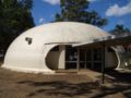
 Peace Park | |||||||||||||
 Ashbury Location in metropolitan Sydney | |||||||||||||
 Interactive map of Ashbury | |||||||||||||
| Coordinates: 33°54′11″S151°06′59″E / 33.90306°S 151.11639°E | |||||||||||||
| Country | Australia | ||||||||||||
| State | New South Wales | ||||||||||||
| City | Sydney | ||||||||||||
| LGAs | |||||||||||||
| Location |
| ||||||||||||
| Established | 1919 | ||||||||||||
| Government | |||||||||||||
| • State electorates | |||||||||||||
| • Federal divisions | |||||||||||||
| Area | |||||||||||||
• Total | 1.03 km2 (0.40 sq mi) | ||||||||||||
| Elevation | 37 m (121 ft) | ||||||||||||
| Population | |||||||||||||
| • Total | 3,353 (2021 census) [1] | ||||||||||||
| • Density | 3,255/km2 (8,430/sq mi) | ||||||||||||
| Postcode | 2193 | ||||||||||||
| |||||||||||||
Ashbury is a suburb in the Inner West of Sydney, in the state of New South Wales, Australia. It lies in the local government area of City of Canterbury-Bankstown [2] with some areas in the Inner West Council [3] and is about 10 kilometres south-west of the Sydney central business district. The postcode is 2193, the same as neighbouring Canterbury and Hurlstone Park.
Contents
- History
- Early Subdivision Plans
- Transport
- Schools
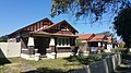
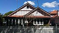
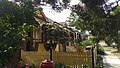
- Housing
- Parks
- Heritage Conservation
- Special character area
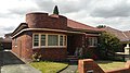
- Heritage Architecture
- Federation and Inter-war Period architecture
- Heritage listings
- Demographics
- Notable residents
- Politics
- References
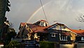
Ashbury is mostly residential and has no commercial centre, although there are a few shops on King Street. Its major landmark is Peace Park, the highest point in the Canterbury local government area. Ashbury derived its name from the two neighbouring suburbs Ashfield and Canterbury. It is near Canterbury Park Racecourse.


