Belmore, New South Wales

Last updated

Belmore
Sydney,  New South Wales
Belmore2.jpg
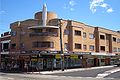
Burwood Road, Belmore
Belmore, New South Wales
Population13,781 (2021 census) [1]
Postcode(s) 2192
Elevation33 m (108 ft)
Location11 km (7 mi) south-west of Sydney CBD
LGA(s) City of Canterbury-Bankstown
State electorate(s) Canterbury
Federal division(s)
Suburbs around Belmore:
Greenacre Strathfield Canterbury
Lakemba Belmore Campsie
Roselands Kingsgrove Clemton Park

Belmore is a suburb of Sydney, in the state of New South Wales, Australia. Belmore is located 11 kilometres south-west of the Sydney central business district, in the local government area of the City of Canterbury-Bankstown.

Contents

History

Belmore is named after the fourth Earl of Belmore, Governor of New South Wales from 1868 to 1872. The area was known as Darkwater in its early days. Some of the first land grants in 1810 were 40.5 hectares (100 acres ) to Richard Robinson east of Sharp Street and Kingsgrove Road and 24 hectares (60 acres) to Thomas Mansfield, to the west. Francis Wild and John Sullivan were each granted 12 hectares (30 acres) in 1823. The area was originally used for market gardens and orchards. Subdivision started after the railway came through in 1895. [2]

The first school, Belmore South Primary School opened on 25 April 1892 and the post office opened in 1907.[ citation needed ] The town centre began developing in the 1920s and features some classic examples of art-deco architecture.

Heritage listings

Belmore has a number of heritage-listed sites, including:

Houses

Belmore has a high percentage of period homes.[ citation needed ] It is predominantly a low-rise residential area full of well-maintained period family homes with large back-yards, wide tree-lined streets, and small parks and playgrounds. Art Deco shop façades dominate the small shopping strip. There are now an increasing number of high-rise units in the suburb mostly along Canterbury Road.

Commercial area

Belmore contains a mixture of residential, significant landmarks, commercial and industrial developments. The main commercial area is located along Burwood Road, near Belmore railway station. Commercial and industrial developments are also located along Canterbury Road and surrounding streets.

Transport

Belmore railway station is located on the Bankstown railway line. The line was opened in 1895 and electrified in 1926. The station at Belmore opened on 1 February 1895. The station was temporarily closed on 30 September 2024 to allow for the line to be converted to Sydney Metro standards. Once reopened, the station will be serviced by the Metro North West & Bankstown Line. [4]

Belmore has many bus routes navigating to the south, to the north and the inner south west to the Sydney CBD.

Religious facilities

Schools

Sport

Belmore Sports Ground is the home ground of the National Rugby League team Canterbury-Bankstown Bulldogs. It is the current home ground for New South Wales Premier League team Sydney Olympic. The "Back to Belmore" campaign was established in August 2005 to upgrade Belmore Sports Grounds as a top-class sporting facility to NRL standards for the Bulldogs to stage a select number of NRL games at their traditional home ground in the long-term future.

Demographics

According to the 2021 census of population, there were 13,781 residents in Belmore.

References

  1. 1 2 Australian Bureau of Statistics (28 June 2022). "Belmore (State Suburb)". 2021 Census QuickStats. Retrieved 4 August 2024. OOjs UI icon edit-ltr-progressive.svg
  2. Pollen, Frances (1990). The Book of Sydney Suburbs. Australia: Angus & Robertson Publishers. p. 26. ISBN   0-207-14495-8.
  3. "Belmore Railway Station Group". New South Wales State Heritage Register . Department of Planning & Environment. H01081. Retrieved 18 May 2018. CC BY icon.svg Text is licensed by State of New South Wales (Department of Planning and Environment) under CC BY 4.0 licence .
  4. Minister for Transport (25 September 2024). "T3 Bankstown line to close from Monday" (Press release). NSW Government . Retrieved 13 October 2024.
  5. "THÀNH VIÊN GIÁO HỘI". The Unified Vietnamese Buddhist Congregation of Australia - New Zealand. Retrieved 14 July 2021.
  6. All Saints Grammar
  7. State Heritage Register

33°55′3″S151°5′16″E / 33.91750°S 151.08778°E / -33.91750; 151.08778