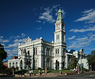
The Inner West of Sydney is an area directly west of the Sydney central business district, New South Wales, Australia. The suburbs that make up the Inner West are predominantly located along the southern shore of Port Jackson, stretching south to the shores of the Cooks River. The western boundary of the Inner West is approximately the A3 arterial road, which divides the Inner West from the Greater Western Sydney region. The Inner West is much larger than the Inner West Council local government area. The Inner West roughly corresponds with the Parish of Petersham and Parish of Concord, two cadastral divisions used for land titles.

The Division of Blaxland is an Australian electoral division in the state of New South Wales.

Villawood Immigration Detention Centre, originally Villawood Migrant Hostel or Villawood Migrant Centre, split into a separate section named Westbridge Migrant Hostel from 1968 to 1984, is an Australian immigration detention facility located in the suburb of Villawood in Sydney, Australia.

Villawood, a suburb of local government areas City of Canterbury-Bankstown and City of Fairfield, is 22 kilometres west of the Sydney central business district, in the state of New South Wales, Australia, and is a part of the Greater Western Sydney region.

Villawood railway station is located on the Main South line, serving the Sydney suburb of Villawood. It is served by Sydney Trains T3 Bankstown line services.

Leightonfield railway station is located on the Main South line, serving the Sydney suburb of Villawood. It is served by Sydney Trains T3 Bankstown line services.

Chester Hill, a suburb of the City of Canterbury-Bankstown local government area, is located 19 kilometres west of the Sydney central business district, in the state of New South Wales, Australia, and is part of Western Sydney, Chester Hill shares the postcode of 2162 with the neighbouring suburb of Sefton.

Chullora, a suburb in the City of Canterbury-Bankstown of local government area, is located 15 kilometres west of the Sydney central business district, in the state of New South Wales, Australia. It is part of the Greater Western Sydney region. The suburb is entirely industrial and commercial, and has no residents.

Carramar is a suburb of Sydney, in the state of New South Wales, Australia. Carramar is located 30 kilometres west of the Sydney central business district, in the local government area of the City of Fairfield and is part of the Greater Western Sydney region.

Clyde is a locality of Sydney, in the state of New South Wales, Australia. Clyde is located 21 kilometres west of the Sydney central business district in the local government area of the City of Parramatta. Clyde is part of the Greater Western Sydney region.

Fairfield East is a suburb of Sydney, in the state of New South Wales, Australia. Fairfield East is located 22 kilometres (14 mi) west of the Sydney central business district in the local government area of the City of Fairfield. Fairfield East is part of the Greater Western Sydney region. Fairfield East shares the postcode of 2165 with nearby suburbs of Fairfield, Fairfield Heights and Fairfield West.

Fairfield is an electoral district of the Legislative Assembly of the Australian state of New South Wales in Sydney's West. Fairfield has historically been one of the safest Labor seats in New South Wales and is considered a part of Labor's heartland in Western Sydney. It is currently represented by Guy Zangari of the Labor Party.

Baxter's Bus Lines, also known as Holroyd Bus Lines Pty Ltd, is an Australian bus charter company in Sydney. Until August 2006, it operated route bus services in Western Sydney.

Busways is an Australian bus company operating services in Western Sydney, and in the Central Coast, Great Lakes, Mid North Coast regions of New South Wales and Adelaide. It is the largest privately-owned bus operator in Australia.
Ladislav "Les" Scheinflug is a former football (soccer) player and coach.
Bass High School is a comprehensive, co-educational government high school in Bass Hill, a south-western suburb of Sydney, New South Wales, Australia.

Custom Bus is an Australian bus body builder in St Marys, New South Wales.
Delwood Coaches was an Australian bus company operating services in Granville, Western Sydney.

The Western Sydney Freight Line (WSFL) is a proposed freight railway line between the Main Western railway line at St Marys and the Southern Sydney Freight Line (SSFL) at Villawood, via a new intermodal terminal near Eastern Creek. The NSW Government committed to establishing a corridor for the future WSFL as part of its Freight & Ports Strategy in 2013. Corridor preservation for the WSFL is also considered a priority under the State Infrastructure Strategy. Constraints analysis and consultation took place between 2015 and 2017, with the line in operation "before 2030". The project is expected to cost in the order of $1 billion.

The Horsley Drive is a 13-kilometre (8.1 mi) urban sealed road located in the City of Fairfield in greater western Sydney, New South Wales, Australia. The road's northwestern terminus is located at the entrance of Western Sydney Parklands in Horsley Park, with its southeastern terminus located at the road's junction with Hume Highway, located in Villawood.


