Canterbury Hospital

Last updated

Canterbury Hospital
Sydney Local Health District
Canterbury Hospital
Geography
Location575 Canterbury Road, Campsie, Sydney, NSW, Australia
Coordinates 33°55′11″S151°05′54″E / 33.9196°S 151.0984°E / -33.9196; 151.0984 Coordinates: 33°55′11″S151°05′54″E / 33.9196°S 151.0984°E / -33.9196; 151.0984
Organisation
Care system Public Medicare (AU)
Type Teaching
Affiliated university The University of Sydney
Services
Emergency department Yes
Beds217
SpecialityMaternity, geriatrics, general medicine
History
Opened1929
Links
Website Official Website
Lists Hospitals in Australia

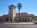
The Canterbury Hospital is a teaching hospital in Campsie, a south-western suburb of Sydney, New South Wales, Australia.

Contents

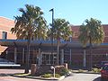
Canterbury Hospital was opened in 1929 and was rebuilt in 1998.

Canterbury Hospital is one of many hospitals in a network under the management of Sydney Local Health District. Canterbury Hospital has links to Concord Repatriation General Hospital, Royal Prince Alfred Hospital and the University of Sydney, offering health services to residents in the Canterbury and Bankstown area of Sydney.

Canterbury Hospital and community health centre cater for a local population of 220,000 of which 66% come from non-English speaking backgrounds.[ citation needed ]

See also

Related Research Articles

Canterbury is a city located in the county of Kent in southeast England. It may also refer to:

<span class="mw-page-title-main">Canterbury-Bankstown Bulldogs</span> Australian rugby league club

The Canterbury-Bankstown Bulldogs are an Australian professional rugby league football club based in Belmore, a suburb in the Canterbury-Bankstown region of Sydney. They compete in the NRL Telstra Premiership, as well as competitions facilitated by the New South Wales Rugby League, including the Canterbury Cup NSW, the Jersey Flegg Cup, Harvey Norman Women's Premiership, Tarsha Gale Cup, S. G. Ball Cup and the Harold Matthews Cup.

<span class="mw-page-title-main">Inner West</span> Region in New South Wales, Australia

The Inner West of Sydney is an area directly west of the Sydney central business district, New South Wales, Australia. The suburbs that make up the Inner West are predominantly located along the southern shore of Port Jackson, stretching south to the shores of the Cooks River. The western boundary of the Inner West is approximately the A3 arterial road, which divides the Inner West from the Greater Western Sydney region. The Inner West is much larger than the Inner West Council local government area. The Inner West roughly corresponds with the Parish of Petersham and Parish of Concord, two cadastral divisions used for land titles.

<span class="mw-page-title-main">Lewisham, New South Wales</span> Suburb of Sydney, New South Wales, Australia

Lewisham is a suburb in the Inner West of Sydney, in the state of New South Wales, Australia. Lewisham is located 7 kilometres south-west of the Sydney central business district, in the local government area of Inner West Council. The postcode is 2049. Lewisham is surrounded by the suburbs of Petersham, Dulwich Hill, Summer Hill, Haberfield and Leichhardt.

<span class="mw-page-title-main">Dulwich Hill, New South Wales</span> Suburb of Sydney, New South Wales, Australia

Dulwich Hill is a suburb in the Inner West of Sydney, in the state of New South Wales, Australia. It is 7.5 kilometres south-west of the Sydney central business district, in the local government area of Inner West Council. Dulwich Hill stretches south to the shore of the Cooks River.

<span class="mw-page-title-main">Petersham, New South Wales</span> Suburb of Sydney, New South Wales, Australia

Petersham is a suburb in the Inner West of Sydney, in the state of New South Wales, Australia. Petersham is located 6 kilometres south-west of the Sydney central business district, in the local government area of Inner West Council. Petersham is known for its extensive Portuguese commercial offerings, with many Portuguese businesses and restaurants, although only 156 (1.9%) of the population was actually born in Portugal.

South Western Sydney is a region of the metropolitan area in southwest Sydney, New South Wales, Australia. It is part of the predominantly working class area of Greater Western Sydney. The region lies in the Cumberland Plain.

<span class="mw-page-title-main">Canterbury, New South Wales</span> Suburb of Sydney, New South Wales, Australia

Canterbury is a suburb of south-western Sydney, in the state of New South Wales, Australia. Canterbury is located 10.5 kilometres (6.5 mi) south-west of the Sydney central business district in the City of Canterbury-Bankstown.

<span class="mw-page-title-main">Campsie railway station</span> Railway station in Sydney, New South Wales, Australia

Campsie railway station is located on the Bankstown line, serving the Sydney suburb of Campsie. It is served by Sydney Trains T3 Bankstown line services.

<span class="mw-page-title-main">Belmore railway station</span> Railway station in Sydney, New South Wales, Australia

Belmore railway station is a heritage-listed railway station located on the Bankstown line at Burwood Road, Belmore in the City of Canterbury-Bankstown local government area of New South Wales, Australia. It is served by Sydney Trains T3 Bankstown line services. It was designed and built by NSW Government Railways from 1895 to 1937. It is also known as Belmore Railway Station Group and Burwood Road. The property was added to the New South Wales State Heritage Register on 2 April 1999.

Bankstown Lidcombe Hospital is teaching hospital with tertiary affiliations to the University of New South Wales, University of Sydney and Western Sydney University providing a wide range of general medical and surgical services and sub-specialty services to the Bankstown/Canterbury community. It is part of South Western Sydney Local Health District.

<span class="mw-page-title-main">City of Canterbury (New South Wales)</span> Former local government area in New South Wales, Australia

The City of Canterbury was a local government area in the south–west region of Sydney, New South Wales, Australia. The city was primarily residential and light industrial in character, and was home to over 130 nationalities. With a majority of its residents being born overseas, the council marketed itself as the "City of Cultural Diversity." First incorporated as the Municipality of Canterbury in 1879, the council became known as the City of Canterbury in 1993.

<span class="mw-page-title-main">Kingsgrove</span> Suburb of Sydney, New South Wales, Australia

Kingsgrove is a suburb in Southern Sydney, New South Wales, Australia. Kingsgrove is 13 kilometres (8.1 mi) south-west of the Sydney central business district and lies across the local government areas of the City of Canterbury-Bankstown, Bayside Council and the Georges River Council.

<span class="mw-page-title-main">Campsie, New South Wales</span> Suburb of Sydney, New South Wales, Australia

Campsie is a suburb in the state of New South Wales, Australia. Campsie is 11 kilometres south west of the Sydney central business district, on the southern bank of the Cooks River. Campsie is one of the administrative centres of the City of Canterbury-Bankstown.

<span class="mw-page-title-main">Cooks River</span> River in Sydney, New South Wales, Australia

The Cooks River, a semi-mature tide-dominated drowned valley estuary, is a tributary of Botany Bay, located in south-eastern Sydney, New South Wales, Australia.

<span class="mw-page-title-main">Clemton Park, New South Wales</span> Suburb of Sydney, New South Wales, Australia

Clemton Park is a suburb in south-western Sydney, in the state of New South Wales, Australia. It is 13 kilometres south-west of the Sydney central business district in the City of Canterbury-Bankstown. The suburb is approximately bounded by Cup and Saucer Creek, Bexley Road in the east, William Street in the south and Kingsgrove Road, but excludes most of the properties which face onto those roads. Those properties are instead in the neighbouring suburbs of Earlwood, Kingsgrove and Campsie.

<span class="mw-page-title-main">Croydon Park, New South Wales</span> Suburb of Sydney, New South Wales, Australia

Croydon Park is a suburb in the Inner West of Sydney, in the state of New South Wales, Australia. Croydon Park is 10 kilometres south-west of the Sydney central business district and is divided between the local government areas of the City of Canterbury-Bankstown, Municipality of Burwood and Inner West Council. Croydon is a separate suburb, to the north.

<span class="mw-page-title-main">Canterbury-Bankstown</span> Region in New South Wales, Australia

Canterbury-Bankstown is a customary region of Sydney, Australia, in the south-western suburbs. The area is located to the north of the St George region and to the south of the Inner West region. The Bankstown railway line serves many of the suburbs in this region. The suburbs of the Canterbury-Bankstown region are not specific to the local government area of the City of Canterbury-Bankstown, but includes many of them. The region lies on the eastern reaches of the Cumberland Plain.

<span class="mw-page-title-main">City of Canterbury-Bankstown</span> Local government area in New South Wales, Australia

The City of Canterbury Bankstown is a local government area located in the South Western region of Sydney, New South Wales, Australia. The council was formed on 12 May 2016 from a merger of the City of Canterbury and the City of Bankstown, after a review of local government in New South Wales by the state government.

<span class="mw-page-title-main">Canterbury Town Hall</span> Government town hall in New South Wales, Australia

The Canterbury Town Hall was an Australian municipal town hall located at 322 Canterbury Road in Canterbury, a suburb in the Inner West of Sydney, New South Wales. It was built in 1889 in the Victorian Free Classical architectural style by architect W. H. Monckton, and was officially opened on 11 April 1889 by the Prime Minister of New South Wales, Sir Henry Parkes. The Town Hall was the seat of Canterbury Municipal Council from 1889 to 1963. When the council moved to a new purpose-built administration centre on Beamish Street in Campsie, a recognition of the change in economic importance of Campsie, the town hall was quickly disposed of by Council and demolished, being replaced by a service station. Today the Town Hall site is part derelict and part paint shop.

References