Pressure Tunnel and Shafts

Last updated

Pressure Tunnel and Shafts
1334 - Pressure Tunnel Shaft No.1 & associated infrastructure - SHR Plan No 2027 (5051435b100).jpg
Heritage boundaries
Location Potts Hill, City of Canterbury-Bankstown, New South Wales, Australia
Coordinates 33°53′43″S151°07′47″E / 33.8954°S 151.1298°E / -33.8954; 151.1298
Built19211935
ArchitectWater Board
Owner Sydney Water
Official namePressure Tunnel and Shafts
Typestate heritage (built)
Designated15 November 2002
Reference no.1630
TypeWater Tunnel
CategoryUtilities - Water
BuildersWater Board
Australia New South Wales relief location map.png
Red pog.svg
Location of Pressure Tunnel and Shafts in New South Wales

Pressure Tunnel and Shafts is a heritage-listed water supply system at Potts Hill, City of Canterbury-Bankstown, New South Wales, Australia. It was designed by the Water Board, which built the tunnel from 1921 to 1935. It is the third largest pressure tunnel in the world. The property is owned by Sydney Water (State Government). It was added to the New South Wales State Heritage Register on 15 November 2002. [1]

Contents

History

Bankstown

This area was selected for settlement by Governor Hunter, who named it Banks Town in honour of eminent botanist, Sir Joseph Banks. In 1795 George Bass and Matthew Flinders had explored the Georges River, named after King George III, the reigning monarch. They sailed along what would later be the southern boundary of the municipality. They reported their findings and were given land grants in the Georges Hall area. Bass received the first grant in 1798, of 100 acres in the vicinity of the present Hazel and Flinders Streets. He did not farm it, and eventually it reverted to the Crown. Flinders' grant was alongside Bass'. He bought more land, until he held 300 acres, but did not farm it. Lieutenant John Shortland and Surveyor James Meehan also got grants. By 1799, 1200 acres on both banks of the river had been granted to marines and ex-convicts. [1]

The area developed slowly, as it was isolated from both Sydney and Parramatta. After Liverpool Road was constructed in 1814 it began to develop rapidly, and settlements grew up along the road. Bushrangers were a problem, and in Bankstown's early days, two, Patrick Sullivan and James Moran, were hung on makeshift gallows on the site of the present Bankstown Water Tower. A few days later several of their companions were also hung there. They were probably interred in nearby unconsecrated land. [1]

In 1831 Michael Ryan was granted 100 acres in Bankstown, which included this site, and for many years the area was called Ryan's Paddock. [1]

The Church of England School established here in 1862, becoming the first public school in 1868, but was moved to North Bankstown in 1913. The first post office opened in 1863, but closed in 1918. [1]

Water Supply Tunnel

Investigation for a large pressure tunnel was begun in 1914, to assist the trunk mains between Potts Hill and Crown Street. The tunnel was to extend from Potts Hill Reservoir to the Waterloo pumping station, approximately 16 kilometres. To allow for maintenance and cleaning, it was designed as two cylindrical tubes, each 1.8 metres in diameter. It was approved by the Parliamentary Standing Committee on Public Works in 1919. [1]

Trial bores were put down in 1921 and 1922. The first tests were conducted between Potts Hill No. 1 and No.5, a length of 4 kilometres, but extensive rupturing of the lining occurred. Further fractures developed during testing of the tunnel between shafts 6 and 9. The section of the Pressure Tunnel between shafts 1 and 5 was commissioned in 1929 due to the urgent need for water. In 1930 the Board approved lining the entire length of the tunnel with steel tube (interior diameter of 8'3"). The tubing allowed for internal securing of the individual sections of the tube. The annular space between the tube and the tunnel was filled with blue metal concrete. Due to lack of funds the lining of the pipe was ceased until 1933 when funds were raised to complete the job.

In 1933 a Royal Commission into the failure of the internal lining was ordered by the government. Lining of the Pressure Tunnel was underway by this point but the Royal Commission determined responsibility of the failures. The report contained great details of pressure tunnels and failures around the world and led to an influx of qualified engineers to the Water Board of the time. [1]

The lining was completed by 1935. The internal lining of the pipes was done with bituman which was done in the factory during manufacture. In 1961 the tunnel was the third largest in the world. [1] The bituman lining was replaced cement lining between 1961 and 1963, as soon as the adjacent City Tunnel was complete. [1]

Description

Beginning at Potts Hill, the tunnel passes under the suburbs of Chullora, Bankstown, Enfield, Canterbury, Ashfield, Petersham, Marrickville, Erskineville, and Waterloo at a depth below ground level varying for 15m to 67m beneath high ground at Ashfield. Its maximum grade is 1 in 100, and its minimum is 1 in 2000. Its total length is approximately 16 kilometres. [1]

The pipes are lined with sand-cement mortar and the space between the liners and walls of the tunnel is filled with concrete to support the liner against deformation from internal pressures and as a protection against corrosion. Its delivery capacity can be increased by booster pumps at Potts Hill. [1]

Seventeen shafts were constructed along the Pressure Tunnel. Of these Shaft 1 is in Rookwood Road near Potts Hill Pumping Station. Shaft 17 is located at Waterloo at the former Central Workshops. Shafts 2, 3, 7, 8, 13 and 16 have all been filled. Shaft 5 is the dewatering shaft that is located at Therry St and discharges into the Cooks River. Shaft 11 is another dewatering shaft which discharges into Hawthorne Canal. Shaft 4 is located on Roberts Road, Shaft 12 on Chester St at Petersham, Shaft 14 on Station St at Newtown and Shaft 15 on Newton St. Shaft 6 (also referred to as Offtake Shaft No. 2) sees a change in tunnel levels. The Tunnel level was raised by 36m. Shaft 9 is also referred to as Offtake Shaft No. 3 and Shaft 10 is referred to as Offtake Shaft No. 3A. The Shaft structures were constructed at each shaft and are considered to be components of the Pressure Tunnel and shafts. The shaft structures or Pressure Tunnel buildings provide for access to each of the shafts and internal components. [1]

The shafts are metal lined and there are eleven Pressure Tunnel buildings, the first located at Potts Hill and the final one being the Central Workshops. Other buildings are located along the western railway line at Newtown, at Weston St in Lewisham, Watson Ave Ashfield, and St Anne's Square at Strathfield South. [1]

Internally the tunnels are substantially intact. The shafts are considerably altered. [1]

Heritage listing

The Pressure Tunnel is of high historical and technical significance as it represents a successful engineering response to the difficulties of increasing the volume of water from the Potts Hill Reservoir to the Pumping Station at Waterloo, a historically critical link in the water supply of Sydney. It is the third largest pressure tunnel in the world, representing a significant achievement in the provision of a dependable water supply by the Government and Water Board during the inter-war period. [1]

Pressure Tunnel and Shafts was listed on the New South Wales State Heritage Register on 15 November 2002 having satisfied the following criteria. [1]

The place is important in demonstrating the course, or pattern, of cultural or natural history in New South Wales.

The Pressure Tunnel is a key component of Sydney's water supply system whose function has remained unchanged since it was constructed. [1]

The place is important in demonstrating aesthetic characteristics and/or a high degree of creative or technical achievement in New South Wales.

The tunnel is underground and can only be observed from the inside when dewatered. [1]

The place has strong or special association with a particular community or cultural group in New South Wales for social, cultural or spiritual reasons.

The Pressure Tunnel and shafts are socially significant as they provided large volumes of water to the growing population of Sydney and surrounding suburbs. It provided water to the population during periods of drought and is likely to be held in high regard by the community for the function it plays. [1]

The place has potential to yield information that will contribute to an understanding of the cultural or natural history of New South Wales.

The construction of the tunnel was delayed when the two tunnelling machine imported from England were unable to tunnel through the sandstone bedrock. The sandstone was far too hard for the cutting tools and manual labour was used instead. The fractures that resulted under full head provided a better understanding of the substrata and its properties. [1]

The place possesses uncommon, rare or endangered aspects of the cultural or natural history of New South Wales.

This item is rare in NSW. It is the third largest pressure tunnel in the world. [1]

The place is important in demonstrating the principal characteristics of a class of cultural or natural places/environments in New South Wales.

It is representative of the successful engineering response to the difficulties of increasing the volume of water from Potts Hill to Waterloo, and the provision of a dependable water supply during the inter-war period. [1]

See also

Related Research Articles

<span class="mw-page-title-main">Inner West</span> Region in New South Wales, Australia

The Inner West of Sydney is an area directly west of the Sydney central business district, New South Wales, Australia. The suburbs that make up the Inner West are predominantly located along the southern shore of Port Jackson, stretching south to the shores of the Cooks River. The western boundary of the Inner West is approximately the A3 arterial road, which divides the Inner West from the Greater Western Sydney region. The Inner West is much larger than the Inner West Council local government area. The Inner West roughly corresponds with the Parish of Petersham and Parish of Concord, two cadastral divisions used for land titles.

<span class="mw-page-title-main">Potts Hill, New South Wales</span> Suburb of Sydney, New South Wales, Australia

Potts Hill, a suburb of local government area City of Canterbury-Bankstown, is 21 kilometres south-west of the Sydney central business district, in the state of New South Wales, Australia. It is a part of the South-western Sydney region.

<span class="mw-page-title-main">Guildford, New South Wales</span> Suburb of Sydney, New South Wales, Australia

Guildford is a suburb of Sydney, in the state of New South Wales, Australia. Guildford is located 27 kilometres west of the Sydney central business district, in the local government area of Cumberland City Council. Guildford is part of the Western Sydney region. Guildford is the home of the first KFC in Australia.

<span class="mw-page-title-main">Thames Water Ring Main</span> London water supply infrastructure

The Thames Water Ring Main is a system of approximately 80 km (50 mi) of concrete tunnels which transfer drinking water from water treatment works in the Thames and River Lea catchments for distribution within central London.

<span class="mw-page-title-main">Busby's Bore</span>

"Building Vol. 23, No. 138 ". Trove. Retrieved 6 October 2022.

<span class="mw-page-title-main">Prospect Reservoir</span> Dam in Western Sydney, New South Wales

The Prospect Reservoir is a heritage-listed 50,200-megalitre potable water supply and storage reservoir created by the Prospect Dam, across the Prospect Creek located in the Western Sydney suburb of Prospect, in New South Wales, Australia. The eastern bounds of the reservoir are a recreational area and the western periphery are within the bounds of Western Sydney Parklands. It was added to the New South Wales State Heritage Register on 18 November 1999.

<span class="mw-page-title-main">1998 Sydney water crisis</span> Water contamination event in Sydney, Australia

The 1998 Sydney water crisis involved the suspected contamination of the water supply system of Greater Metropolitan Sydney by the microscopic pathogens Cryptosporidium and Giardia between July and September 1998.

Liverpool Offtake Reservoir is a small reservoir in Cecil Hills, New South Wales. Built along with the Upper Nepean Scheme it replaced the Liverpool Weir supply.

<span class="mw-page-title-main">Petersham Reservoir</span> Historic site in New South Wales, Australia

Petersham Reservoir is a heritage-listed water reservoir at New Canterbury Road, Petersham, Inner West Council, Sydney New South Wales, Australia. It was designed and built by the New South Wales Public Works Department. It is also known as Petersham Service Reservoir and WS089. The property is owned by Sydney Water. It was added to the New South Wales State Heritage Register on 18 November 1999.

<span class="mw-page-title-main">Bankstown Reservoir</span> Water tower in Bankstown, Sydney, NSW

Bankstown Reservoir is a heritage-protected water tower and a local landmark situated in the suburb of Bankstown, Sydney, New South Wales, Australia. Located 22 kilometres (14 mi) west of Sydney CBD, the reservoir is elevated and was built on reinforced concrete piers, which is one of the oldest of this type that is still in use. The reservoir features various decorative attributes, plastered by hand, which lack in other functional reservoirs. Established in 1920, the reservoir serves a large area of South-Western Sydney.

<span class="mw-page-title-main">Potts Hill Reservoirs 1 and 2</span> Historic site in New South Wales, Australia

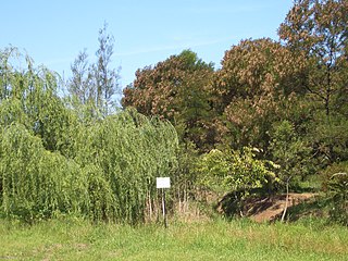
Potts Hill Reservoirs 1 and 2 are heritage-listed reservoirs at Cooper Road, Potts Hill, City of Canterbury-Bankstown, New South Wales, Australia. It was designed by Board of Water Supply and Sewerage and built from 1880. The reservoirs are now maintained by the Board's successor, Sydney Water. It was added to the New South Wales State Heritage Register on 18 November 1999.

The Bondi Ocean Outfall Sewer is a heritage-listed sewerage infrastructure at Blair Street, North Bondi, Sydney, Australia. The sewer line commences at the intersection of Oxford Street and College Street in Darlinghurst and then travels in a more-or-less easterly direction for 6.1 kilometres (3.8 mi) passing through a number of suburbs until it reaches Blair Street in North Bondi. It was designed and built by the Public Works Department between 1880 and 1889. It is also known as BOOS (Bondi Ocean Outfall Sewer) and Main Northern Ocean Outfall Sewer. The property is owned by Sydney Water.

<span class="mw-page-title-main">Waverley Reservoirs</span> Building

The Waverley Reservoirs are four reservoirs, of which two are heritage-listed, located at Paul Street, Bondi Junction, Waverley Municipality, New South Wales, Australia. They were designed and built by the Public Works Department. The property is owned by Sydney Water, an agency of the Government of New South Wales. The properties were added to the New South Wales State Heritage Register on 18 November 1999 and 15 November 2002 respectively.

<span class="mw-page-title-main">Penshurst Reservoirs</span> Historic site in New South Wales, Australia

The Penshurst Reservoirs are heritage-listed reservoirs located at Laycock Road, Penshurst in the Georges River Council local government area of New South Wales, Australia. They were designed and built during 1895 by the NSW Public Works Department. The reservoirs are also known as WS87 & R88, Penshurst Elevated Steel Reservoir No 2 and Penshurst Elevated Concrete Reservoir No 3. The property is owned by Sydney Water, an agency of the Government of New South Wales. The site was added to the New South Wales State Heritage Register on 18 November 1999.

<span class="mw-page-title-main">Guildford West pipehead and water supply canal</span> Historic site in New South Wales, Australia

The Guildford West pipehead and water supply canal is a heritage-listed sewerage infrastructure and water supply canal located at Frank Street, Guildford in the Cumberland Council local government area of New South Wales, Australia. It is also known as Headworks; Industrial Archaeological Site. The property is owned by Sydney Water, an agency of the Government of New South Wales. It was added to the New South Wales State Heritage Register on 15 November 2002.

<span class="mw-page-title-main">Ashfield Reservoir</span> Historic site in New South Wales, Australia

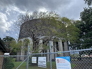
The Ashfield Reservoir is a heritage-listed reservoir located at Holden Street, Ashbury, City of Canterbury-Bankstown, New South Wales, Australia. It was designed and built by the Metropolitan Board of Water Supply and Sewerage. It is also known as Ashfield Reservoir (Elevated) and WS 0003. The property is owned by Sydney Water. It was added to the New South Wales State Heritage Register on 15 November 2002.

<span class="mw-page-title-main">Wahroonga Reservoir</span> Historic site in New South Wales, Australia

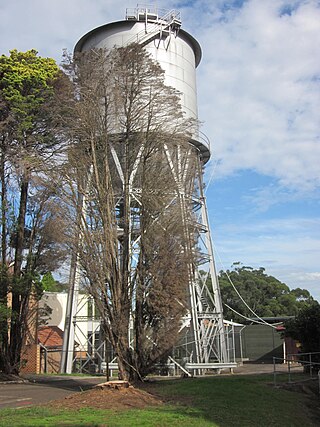
The Wahroonga Reservoir is a heritage-listed reservoir located at 1678 Pacific Highway and Woonona Avenue in the Sydney suburb of Wahroonga in the Ku-ring-gai Council local government area of New South Wales, Australia. It was designed and built by the Metropolitan Board of Water Supply and Sewerage in 1915. It is also known as Wahroonga Reservoir (Elevated) . The property is owned by Sydney Water, a State-owned statutory corporation of the Government of New South Wales. It was added to the New South Wales State Heritage Register on 18 November 1999.

<span class="mw-page-title-main">Pymble Reservoirs No. 1 and No. 2</span> Heritage listed water reservoirs in Pymble, NSW, Australia

The Pymble Reservoirs No. 1 and No. 2 are two heritage-listed reservoirs located at Pacific Highway in the Sydney suburb of Pymble in the Ku-ring-gai Council local government area of New South Wales, Australia. The reservoirs are also known as Pymble Reservoir No. 1 (Covered) and (WS 0097); and Pymble Reservoir No. 2 (Covered) and (WS 0098). The property is owned by Sydney Water, a State-owned statutory corporation of the Government of New South Wales. The reservoirs were added to the New South Wales State Heritage Register on 15 November 2002.

<span class="mw-page-title-main">Sydney Harbour railway electricity tunnel</span> Historic site in New South Wales, Australia

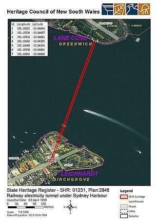
Sydney Harbour railway electricity tunnel is heritage-listed electricity infrastructure running under Sydney Harbour between Birchgrove and Greenwich, Sydney, New South Wales, Australia. It is also known as Balmain to Greenwich Electric Cable Tunnel. It was added to the New South Wales State Heritage Register on 2 April 1999.

Gerald Haskins was a New Zealand born and educated civil engineer, who worked for much of his career in Australia. He was one of the three original principals of the consulting engineering firm, Gutteridge Haskins and Davey, which continues today in the form of the GHD Group.

References

  1. 1 2 3 4 5 6 7 8 9 10 11 12 13 14 15 16 17 18 19 20 21 22 "Pressure Tunnel and Shafts". New South Wales State Heritage Register . Department of Planning & Environment. H01630. Retrieved 2 June 2018. CC-BY icon.svg Text is licensed by State of New South Wales (Department of Planning and Environment) under CC-BY 4.0 licence .

Bibliography

Attribution

CC BY icon-80x15.png This Wikipedia article was originally based on Pressure Tunnel and Shafts , entry number 01630 in the New South Wales State Heritage Register published by the State of New South Wales (Department of Planning and Environment) 2018 under CC-BY 4.0 licence , accessed on 2 June 2018.