Clemton Park, New South Wales

Last updated

Clemton Park
Sydney,  New South Wales
Clemton Park.jpg
William Street and Bexley Road intersection, in neighbouring Earlwood and adjacent to Clemton Park
Clemton Park, New South Wales
Population1,666 (2016 census) [1]
Postcode(s) 2206
Elevation27 m (89 ft)
Location13 km (8 mi) south-west of Sydney CBD
LGA(s) City of Canterbury-Bankstown
State electorate(s) Canterbury
Federal division(s) Barton
Suburbs around Clemton Park:
Belmore Campsie Canterbury
Roselands Clemton Park Earlwood
Beverly Hills Kingsgrove Bexley North

Clemton Park is a suburb in south-western Sydney, in the state of New South Wales, Australia. It is 13 kilometres south-west of the Sydney central business district in the City of Canterbury-Bankstown. The suburb is approximately bounded by Cup and Saucer Creek, Bexley Road in the east, William Street in the south and Kingsgrove Road, but excludes most of the properties which face onto those roads. Those properties are instead in the neighbouring suburbs of Earlwood, Kingsgrove and Campsie.

Contents

Clemton Park is a small suburb and almost entirely residential. Institutions, shops and facilities named or associated with "Clemton Park" are mostly situated outside the suburb boundaries: a small group of shops located at the intersection of Bexley Road and William Street, and Clemton Park Public School, are in the neighbouring suburb of Earlwood. Clemton Park Shopping Village is mostly situated within the suburb of Campsie. [2] The park named "Clemton Park" is situated in Kingsgrove. [3]

History

This area was part of the 50-acre (200,000 m2) Laycock estate granted to Hannah Laycock (1758–1831), the wife of Quartermaster Thomas Laycock (1756–1809), in 1804. Prior to the creation of the locality name, it was part of Earlwood.

Frederick Moore Clements, who became wealthy from selling the family health restorer, Clements Tonic, owned 40 acres (160,000 m2) near William Street until his death in 1920. 'Clementon Park' was an early suggestion for the suburb's name but records show Clemton Park was used from 1925. [4] The name was created as part of a campaign to lobby for an extension of the tram line from the terminus at Earlwood. It was approved as a locality name by Canterbury Council in 1925. It was designated by the Geographical Names Board as a "neighbourhood" name in 1977 until 1993. It became an official suburb, separate from Earlwood, in 2000. [5]

Demographics

At the 2011 census, there were 1,565 residents in Clemton Park. In Clemton Park, 58.1% of people were born in Australia. The most common countries of birth were Greece 6.8%, China 4.7%, Portugal 3.7%, Lebanon 3.0% and Italy 2.2%. Family households (77.1%) were the main type of household, with 21.5% single person households and 1.5% group households. [1]

Facilities

Most of the institutions, shops and facilities named or associated with "Clemton Park" are situated outside the suburb boundaries, including the eponymous Clemton Park, located on Moorefields Road in neighbouring Kingsgrove. [6] It is the home ground of the Earlwood Wanderers Cricket Club 6th-grade team of 2013–14.

Clemton Park Public School is located on Bexley Road in neighbouring Earlwood.

Within the boundaries of Clemton Park itself, there is a small park called Yatama Park. Campsie South Bowling and Recreation Club is located adjacent to Yatama Park.

Related Research Articles

<span class="mw-page-title-main">Division of Barton</span> Australian federal electoral division

The Division of Barton is an Australian electoral division in the state of New South Wales.

<span class="mw-page-title-main">Dulwich Hill</span> Suburb of Sydney, New South Wales, Australia

Dulwich Hill is a suburb in the Inner West of Sydney, in the state of New South Wales, Australia. It is 7.5 kilometres south-west of the Sydney central business district, in the local government area of Inner West Council. Dulwich Hill stretches south to the shore of the Cooks River.

<span class="mw-page-title-main">Canterbury, New South Wales</span> Suburb of Sydney, New South Wales, Australia

Canterbury is a suburb of south-western Sydney, in the state of New South Wales, Australia. Canterbury is located 10.5 kilometres (6.5 mi) south-west of the Sydney central business district in the City of Canterbury-Bankstown.

<span class="mw-page-title-main">Bexley North railway station</span> Railway station in Sydney, New South Wales, Australia

Bexley North railway station is located on the East Hills line, serving the Sydney suburb of Bexley North. It is served by Sydney Trains T8 Airport & South line services.

<span class="mw-page-title-main">Undercliffe, New South Wales</span> Place in New South Wales, Australia

Undercliffe is an eastern section of the suburb of Earlwood located in South Western Sydney, New South Wales, Australia. Undercliffe is situated 10 kilometres south-west of the Sydney central business district within the local government area of the City of Canterbury-Bankstown.
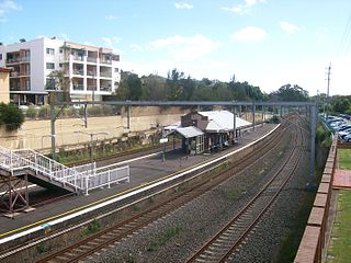
<span class="mw-page-title-main">Bardwell Park railway station</span> Railway station in Sydney, New South Wales, Australia

Bardwell Park railway station is located on the East Hills line, serving the Sydney suburb of Bardwell Park. It is served by Sydney Trains T8 Airport & South line services.

<span class="mw-page-title-main">Division of Watson</span> Australian federal electoral division

The Division of Watson is an Australian electoral division in the state of New South Wales.

<span class="mw-page-title-main">Narwee, New South Wales</span> Suburb of Sydney, New South Wales, Australia

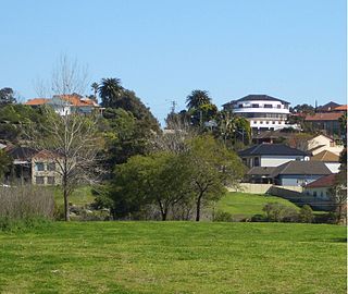
Narwee is a suburb in southern Sydney, in the state of New South Wales, Australia. Narwee is located 18 kilometres south of the Sydney central business district and is part of the St George area. Narwee is in local government areas of City of Canterbury-Bankstown and Georges River Council. The postcode is 2209, which it shares with neighbouring Beverly Hills.

<span class="mw-page-title-main">Kingsgrove</span> Suburb of Sydney, New South Wales, Australia

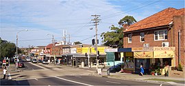
Kingsgrove is a suburb in Southern Sydney, New South Wales, Australia. Kingsgrove is 13 kilometres (8.1 mi) south-west of the Sydney central business district and lies across the local government areas of the City of Canterbury-Bankstown, Bayside Council and the Georges River Council.

<span class="mw-page-title-main">Wolli Creek</span> River in New South Wales, Australia

Wolli Creek is an urban watercourse of the Cooks River catchment located in the southern suburbs of Sydney, in New South Wales, Australia.

<span class="mw-page-title-main">Chester Hill</span> City in New South Wales, Australia

Chester Hill, a suburb of the City of Canterbury-Bankstown local government area, is located 25 kilometres west of the Sydney central business district, in the state of New South Wales, Australia, and is part of Western Sydney, Chester Hill shares the postcode of 2162 with the neighbouring suburb of Sefton.

<span class="mw-page-title-main">Greenacre, New South Wales</span> Suburb of Sydney, New South Wales, Australia

Greenacre is a suburb in South-western Sydney, located 20 kilometres south-west of the Sydney central business district in the state of New South Wales, Australia. Most of Greenacre is in the local government area of the City of Canterbury-Bankstown, while a part in the east is in the Municipality of Strathfield.

<span class="mw-page-title-main">Campsie, New South Wales</span> Suburb of Sydney, New South Wales, Australia

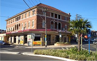
Campsie is a suburb in the state of New South Wales, Australia. Campsie is 11 kilometres south west of the Sydney central business district, on the southern bank of the Cooks River. Campsie is one of the administrative centres of the City of Canterbury-Bankstown.

<span class="mw-page-title-main">Earlwood, New South Wales</span> Suburb of Sydney, New South Wales, Australia

Earlwood is a suburb of Sydney, in the state of New South Wales, Australia. Earlwood is located 10 kilometres south-west of the Sydney central business district, and is part of the Canterbury-Bankstown area. It is in the local government area of the City of Canterbury-Bankstown.

<span class="mw-page-title-main">Croydon Park, New South Wales</span> Suburb of Sydney, New South Wales, Australia

Croydon Park is a suburb in the Inner West of Sydney, in the state of New South Wales, Australia. Croydon Park is 10 kilometres south-west of the Sydney central business district and is divided between the local government areas of the City of Canterbury-Bankstown, Municipality of Burwood and Inner West Council. Croydon is a separate suburb, to the north.

<span class="mw-page-title-main">Turrella railway station</span> Railway station in Sydney, New South Wales, Australia

Turrella railway station is located on the East Hills line, serving the Sydney suburb of Turrella. It is served by Sydney Trains T8 Airport & South line services.

<span class="mw-page-title-main">Cup and Saucer Creek</span> Creek in Sydney, New South Wales, Australia

Cup and Saucer Creek, an urban watercourse of the Cooks River catchment, is located in the Canterbury-Bankstown region of Sydney, in New South Wales, Australia.

<span class="mw-page-title-main">Canterbury-Bankstown</span> Region in New South Wales, Australia

Canterbury-Bankstown is a customary region of Sydney, Australia, in the south-western suburbs. The area is located to the north of the St George region and to the south of the Inner West region. The Bankstown railway line serves many of the suburbs in this region. The suburbs of the Canterbury-Bankstown region are not specific to the local government area of the City of Canterbury-Bankstown, but includes many of them. The region lies on the eastern reaches of the Cumberland Plain.

Highway Tours was an Australian bus company operating services in the south-western suburbs of Sydney, New South Wales.

<span class="mw-page-title-main">City of Canterbury-Bankstown</span> Local government area in New South Wales, Australia

Canterbury-Bankstown Council, trading as the City of Canterbury Bankstown, is a local government area located in the South Western region of Sydney, New South Wales, Australia. The council was formed on 12 May 2016 from a merger of the City of Canterbury and the City of Bankstown, after a review of local government in New South Wales by the state government. The eastern portion of the council that was once City of Canterbury falls within the northern portion of The Parish of St George above Wolli Creek and The M5 but below The Cooks River.

References

  1. 1 2 Australian Bureau of Statistics (27 June 2017). "Clemton Park (State Suburb)". 2016 Census QuickStats. Retrieved 11 April 2018. OOjs UI icon edit-ltr-progressive.svg
  2. Celmton Park Shopping Village – Centre Info
  3. City of Canterbury-Bankstown, Clemton Park
  4. Pollon, Frances; Healy, Gerald (1988). The Book of Sydney Suburbs. Angus & Robertson. p. 63. ISBN   978-0-207-14495-0.
  5. NSW Geographical Names Board, "Earlwood" (suburb)
  6. "Clemton Park". City of Canterbury Bankstown.

33°55′48″S151°06′22″E / 33.930°S 151.106°E / -33.930; 151.106