Leichhardt, New South Wales

Last updated

Leichhardt
Sydney,  New South Wales
Leichhardt Town Hall corner.jpg
Leichhardt Town Hall
Leichhardt, New South Wales
Population15,158 (SAL 2021) [1]
Established1846
Postcode(s) 2040
Elevation40 m (131 ft)
Area4.565 km2 (1.8 sq mi)
Location5 km (3 mi) west of Sydney CBD
LGA(s) Inner West Council
State electorate(s) Balmain
Federal division(s) Grayndler
Suburbs around Leichhardt:
Haberfield Lilyfield Rozelle
Haberfield Leichhardt Annandale
Lewisham Petersham Stanmore

Leichhardt is a suburb in the Inner West [2] of Sydney, in the state of New South Wales, Australia. Leichhardt is located 5 kilometres west of the Sydney central business district (CBD) and is the administrative centre for the local government area (LGA) of the Inner West Council. The suburb is bordered by Haberfield to the west, Annandale to the east, Lilyfield to the north and Petersham, Lewisham and Stanmore to the south.

Contents

History

Aboriginal anthropology

Leichhardt was once an area broadly inhabited by the Wangal band of the Dharug (Eora) language group. The 'Eora people' was the name given to coastal Aboriginal people around Sydney – Eora means from this place – local Aboriginal people used this word to describe to Europeans where they came from, and in time the term became used to define Aboriginal people themselves. Wangal country was known as 'wanne' and it originally extended from the suburbs of Balmain and Birchgrove in the east to Silverwater and Auburn in the west. It is unclear how many people were in the tribe; some research indicates in the broader Sydney region there were between 8000 – 10000 indigenous people, but migration over the seasons and violence between tribes would alter this number at different periods. The northern boundary was the Parramatta River. Neighbouring Darug bands were the Cadigal to the east, the Wallumattagal on the northern shore of the Parramatta River and the Bediagal to the south.

European settlement

Leichhardt is named after the Prussian explorer Ludwig Leichhardt, who in the 1840s was feted for his 4,800 km (c. 3000 mi) expedition in search of an overland route from southern Queensland to Port Essington, a British settlement on the far northern coast of Australia (some 300 km to the north of the modern city of Darwin). [3] In 1848, he famously vanished without trace on his attempt to cross the continent from the Darling Downs in Queensland to the Swan River Colony on the Western Australia coast. [4]

Leichhardt was proclaimed a municipality in 1871. In 1949, it was merged with the municipalities of Annandale and Balmain. In 1967, the municipal boundary was altered to include Glebe and parts of Camperdown. In 2003, the municipal boundary was again changed, to exclude Glebe and Forest Lodge, which are now part of the City of Sydney. [5]

Commercial area

Piazza at the Italian Forum Leichhardt Italian Forum 2.JPG
Piazza at the Italian Forum
Shops on Norton Street Norton Street, Leichhardt (Sydney NSW) AUG2019.jpg
Shops on Norton Street

The main commercial area in Leichhardt is located on Norton Street, north of Parramatta Road (Great Western Highway) and parallel to Balmain Road. The Norton Street commercial area contains a mix of residential buildings, restaurants (Italian and others), cafés, eateries and individual retail outlets, including several bookstores and grocery shops. There are also hotels, a Palace Cinema and two of the suburb's two shopping centres – MarketPlace Leichhardt and Norton Plaza. Commercial developments are also found along the length of Parramatta Road.

The Italian Forum, located just off Norton Street, is notable for its design which seeks to emulate the feel of a Mediterranean town piazza. A pedestrian-only central courtyard featuring outdoors and indoors restaurant dining as well as Leichhardt Library is surrounded by small shops and boutiques on the level above, and all overlooked by residential apartments. Norton Street plays host to various events throughout the year, notably the Italian Fiesta in October, which showcases the Italian culture of the area.

The second shopping centre, MarketPlace Leichhardt (formerly Market Town), is located towards Haberfield on the corner of Marion and Flood Streets. MarketPlace Leichhardt has free car parking and is home to Woolworths, Aldi, Target and over 60 specialty stores. The centre opened in 1975 and is in the heart of Leichhardt.

Transport

Parramatta Road at Leichhardt Parramatta Highway Leichhardt (Sydney NSW) AUG2019.jpg
Parramatta Road at Leichhardt

Leichhardt can be accessed by several main roads including Parramatta Road (Great Western Highway), Norton Street, Balmain Road, Marion Street and Catherine Street. The City West Link runs along the northern border of Leichhardt and is a major arterial road, which is part of the A4 and crosses the Anzac Bridge to the CBD. Leichhardt is well serviced by Transit Systems through city and cross regional services. Leichhardt Bus Depot is located on the corner of William and Derbyshire Street.

The following list provides the bus routes in Leichhardt:

Aerial view of the Metropolitan Goods railway line, which has been converted to light rail Metro Goods Haberfield Leichhardt aerial.jpg
Aerial view of the Metropolitan Goods railway line, which has been converted to light rail

The southern portion of Leichhardt is serviced by trains at the nearby Petersham railway station, on the Inner West & Leppington Line. The station is an eight-minute walk from Norton Street, along Railway Street.

The western and northern portions of Leichhardt are serviced by the Inner West Light Rail. Leichhardt North lies on the northern border with Lilyfield, adjacent to the City West Link. Hawthorne, serving the north-west of the suburb, and Marion, near Marion Street, are on the western border with Haberfield. Taverners Hill is adjacent to Parramatta Road and lies in the south-west corner of the suburb.

Leichhardt was served by trams from Sydney's former network from 1887 to the 1950s. The Annandale Line ran down Norton Street. The current bus depot at the top of William Street was a 12 road depot, designed to serve a number of planned lines that were never built. Instead, it was used to stored surplus trams in the off peak period, and was rebuilt as the Government Bus Workshops in 1937. A small spur of track remained and was later used by tour trams going through the depot yard nearest Pioneer Park.

Houses

Being situated close to the city, Leichhardt is an area for great capital growth as it very central and has a lot to offer, so housing is not very cheap and is much sought after. The architecture in Leichhardt ranges from Victorian single fronted brick homes to modern new homes and apartment blocks.

Churches and schools

Leichhardt Uniting Church Leichhardt Methodist Central Hall.JPG
Leichhardt Uniting Church
St Gerasimos Greek Orthodox Church St Gerasimos Greek Orthodox Church.jpg
St Gerasimos Greek Orthodox Church

Leichhardt has a number of primary schools and one secondary school.

Landmarks

Pioneers Memorial Park entrance Leichhardt Pioneers Memorial Park 2.JPG
Pioneers Memorial Park entrance

The following buildings are listed on the Register of the National Estate: [6]

Parks and recreation

Pioneers Memorial Park Leichhardt Pioneers Memorial Park 1.JPG
Pioneers Memorial Park

Culture

Hawthorne Canal Tunnel Mural Hawthorne Canal Tunnel Mural.jpg
Hawthorne Canal Tunnel Mural

Leichhardt is home to many creative industry workers and is known for its colourful and inventive mural art, [8] such as the panorama at the Renwick Lane and at the Hawthorne Canal Railway Underpass. [9] Leichhardt has access to many art and cultural organisations. Commercial galleries are found throughout the area and Boomali Gallery, the Aboriginal Arts Organisation is situated in Flood Street in Leichhardt.

The Italian community has a wealth of social and cultural organisations located in Leichhardt, and work is underway everyday to develop the Italian Forum Cultural Centre. Co.As.It. is one of them and they provide a range of culturally and linguistically appropriate services to enhance the quality of life of the community and to promote the Italian language and culture in New South Wales. The suburb was originally considered to be Sydney's 'little Italy', [10] but that reputation has since decreased. [11]

Leichhardt is the yearly host of the Italian Festa on Norton Street where local traffic is temporarily closed on Norton and neighbouring streets transforming surroundings into a huge European style outdoor café, celebrating Leichhardt's cultural diversity with an International Food Fair, gift stalls, community expos and live entertainment throughout the day. [12] Leichhardt is also known for its café culture with cafés in abundance. The oldest café in the area is Café Sport, which is located on Norton Street.

Population

2016 Census: Leichhardt
Leichhardt [13] Sydney [14] Australia
Population14,6254,321,53523,401,892
Median age363538
Median household income (weekly)$2,256$1,802$1,438
Born in Australia64.2%54.6%66.7%

According to the 2016 census of Population, there were 14,625 people in Leichhardt.

41% of occupied dwellings were terraces, semis or townhouses, 35% were separate density housing houses and 22% were apartments. The average age of people in the suburb was similar to the rest of Sydney (36) and a lower percentage of people owned their homes outright (23.4%) than those paying them off (34.2%) or renting (40.1%). Median loan repayments ($3,000 per month) were much higher than the national figure ($1,755). [13]

Since the middle of the 20th century, Leichhardt has been a centre for the Italian community, reflected in the many Italian-owned businesses in the area. Although it has become less distinctively Italian with the increasing gentrification of the suburb and movement of families to suburbs with larger blocks of land, its Italian character is still palpable, particularly in the popular restaurants and cafés of its main street, Norton Street. Many residents moved to suburbs further away from Sydney as the city has expanded and larger housing blocks became available.

Politics

Notable residents

Related Research Articles

<span class="mw-page-title-main">Inner West</span> Region in New South Wales, Australia

The Inner West of Sydney is an area directly west of the Sydney central business district, New South Wales, Australia. The suburbs that make up the Inner West are predominantly located along the southern shore of Port Jackson, stretching south to the shores of the Cooks River. The western boundary of the Inner West is approximately the A3 arterial road, which divides the Inner West from the Greater Western Sydney region. The Inner West is much larger than the Inner West Council local government area. The Inner West roughly corresponds with the Parish of Petersham and Parish of Concord, two cadastral divisions used for land titles.

<span class="mw-page-title-main">Ashfield, New South Wales</span> Suburb of Sydney, New South Wales, Australia

Ashfield is a suburb in the Inner West of Sydney, in the state of New South Wales, Australia. Ashfield is about 8 kilometres west of the Sydney central business district.

<span class="mw-page-title-main">Glebe, New South Wales</span> Suburb of Sydney, New South Wales, Australia

Glebe is an inner-western suburb of Sydney in New South Wales. Glebe is located 3 kilometres (1.9 mi) southwest of the Sydney central business district and is part of the local government area of the City of Sydney, in the Inner West region.

<span class="mw-page-title-main">Summer Hill, New South Wales</span> Suburb of Sydney, New South Wales, Australia

Summer Hill is a suburb of Sydney, in the state of New South Wales, Australia. Summer Hill is located 7 kilometres west of the Sydney central business district, in the local government area of the Inner West Council.

<span class="mw-page-title-main">Haberfield, New South Wales</span> Suburb of Sydney, New South Wales, Australia

Haberfield is a suburb in the Inner West of Sydney, in the state of New South Wales, Australia. Haberfield is located 6.5 kilometres west of the Sydney central business district in the local government area of the Inner West Council.

<span class="mw-page-title-main">Parramatta Road</span> Road in Sydney, Australia

Parramatta Road is the major historical east-west artery of metropolitan Sydney, New South Wales, Australia, connecting the Sydney CBD with Parramatta. It is the easternmost part of the Great Western Highway. Since the 1990s its role has been augmented by the City West Link and M4 Motorway.

<span class="mw-page-title-main">Lilyfield, New South Wales</span> Suburb of Sydney, New South Wales, Australia

Lilyfield is a suburb in the Inner West of Sydney, in the state of New South Wales, Australia. Lilyfield is located 6 kilometres west of the Sydney central business district, in the local government area of the Inner West Council.

<span class="mw-page-title-main">Division of Grayndler</span> Australian federal electoral division

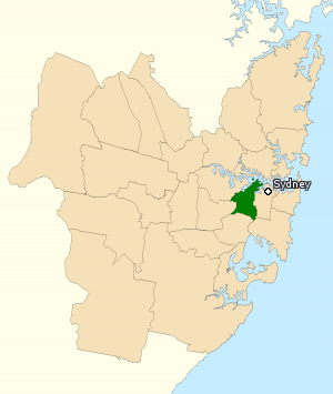
The Division of Grayndler is an Australian electoral division in the state of New South Wales.

<span class="mw-page-title-main">Petersham, New South Wales</span> Suburb of Sydney, New South Wales, Australia

Petersham is a suburb in the Inner West of Sydney, in the state of New South Wales, Australia. Petersham is located 6 kilometres south-west of the Sydney central business district, in the local government area of Inner West Council. Petersham is known for its extensive Portuguese commercial offerings, with many Portuguese businesses and restaurants, although only 156 (1.9%) of the population was actually born in Portugal.
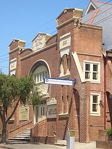
<span class="mw-page-title-main">Rozelle</span> Suburb of Sydney, New South Wales, Australia

Rozelle is a suburb in the inner west of Sydney, in the state of New South Wales, Australia. It is located 4 kilometres west of the Sydney central business district, in the local government area of the Inner West Council.

<span class="mw-page-title-main">Five Dock</span> Suburb of Sydney, New South Wales, Australia

Five Dock is a suburb in the Inner West of Sydney, in the state of New South Wales, Australia. Five Dock is located 10 kilometres west of the Sydney central business district, in the local government area of the City of Canada Bay.

<span class="mw-page-title-main">Municipality of Leichhardt</span> Former local government area in New South Wales, Australia

The Municipality of Leichhardt was a local government area in the inner-west region of Sydney, New South Wales, Australia. It is about 10 kilometres (6.2 mi) west of the Sydney central business district. On 12 May 2016, Leichhardt merged with Marrickville Council and the Municipality of Ashfield to form the Inner West Council.

<span class="mw-page-title-main">Meadowbank, New South Wales</span> Suburb of Sydney, New South Wales, Australia

Meadowbank is a suburb of Sydney, New South Wales, Australia, 15 kilometres north west of the Sydney central business district, in the local government area of the City of Ryde and part of the Northern Sydney region. Meadowbank sits in a valley on the northern bank of the Parramatta River.

<span class="mw-page-title-main">Balmain East</span> Suburb of Sydney, New South Wales, Australia

Balmain East is a suburb in the Inner West of Sydney, in the state of New South Wales, Australia. Balmain East is located three kilometres west of the Sydney central business district, in the local government area of the Inner West Council.

<span class="mw-page-title-main">Iron Cove</span> Bay on the Parramatta River in Australia

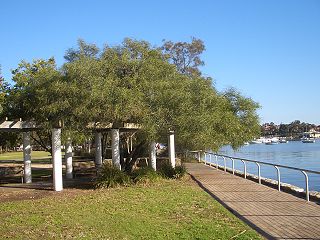
Iron Cove is a bay on the Parramatta River, in the inner-west of Sydney, in the state of New South Wales, Australia. It is approximately 5 kilometres (3.1 mi) due west of Sydney's central business district. It is surrounded by the suburbs of Birchgrove, Balmain, Rozelle, Lilyfield, Haberfield, Five Dock, Rodd Point, Russell Lea and Drummoyne. The bay extends from Longnose Point to the south-west and is fed by the Hawthorne Canal and the Iron Cove Creek.

<span class="mw-page-title-main">Norton Street</span> Street in Sydney, Australia

Norton Street is in the suburb of Leichhardt in Sydney, Australia. It is located 5 kilometres west of the Sydney central business district and is the main commercial street in the suburb.
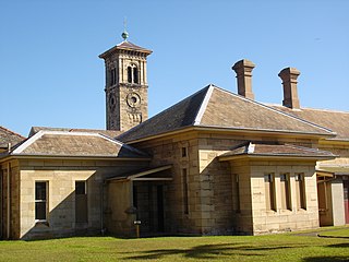
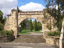
<span class="mw-page-title-main">Annandale, New South Wales</span> Suburb of Sydney, New South Wales, Australia

Annandale is a suburb in the Inner West of Sydney, in the state of New South Wales, Australia. Annandale is located within 5 kilometres west of the Sydney central business district and is part of the local government area of the Inner West Council. Annandale's northern end lies on Rozelle Bay, which is on Sydney Harbour. Glebe lies to its east, Lilyfield and Leichhardt to its west and Stanmore and Camperdown to its south.

<span class="mw-page-title-main">Inner West Light Rail</span> Light rail line in Sydney, New South Wales, Australia

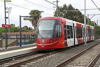
The Inner West Light Rail is a 12.8-kilometre (8.0 mi) light rail line in Sydney, New South Wales, Australia, running from Central railway station through the Inner West to Dulwich Hill and serving 23 stops. It is the original line of the Sydney light rail network, and was originally known as Sydney Light Rail. Light rail services on the line are now branded as the L1 Dulwich Hill Line.

<span class="mw-page-title-main">Inner West Council</span> Local government area in New South Wales, Australia

Inner West Council is a local government area located in the Inner West region of Sydney in the state of New South Wales, Australia. The council makes up the eastern part of this wider region, and was formed on 12 May 2016 from the merger of the former Ashfield, Leichhardt and Marrickville councils.

<span class="mw-page-title-main">White's Creek Aqueduct</span> Heritage-listed sewage aqueduct in Sydney, Australia

White's Creek Aqueduct is a heritage-listed sewage aqueduct at Piper Street, Lilyfield, Inner West Council, Sydney, New South Wales, Australia. It was designed by engineer William Julius Baltzer of the New South Wales Public Works Department and built by the Department from 1897 to 1898. The property is owned by Sydney Water. It was added to the New South Wales State Heritage Register on 18 November 1999.

References

  1. Australian Bureau of Statistics (28 June 2022). "Leichhardt (NSW) (suburb and locality)". Australian Census 2021 QuickStats. Retrieved 28 June 2022.  OOjs UI icon edit-ltr-progressive.svg
  2. Australian Suburb Guide: Sydney Inner West Archived 26 December 2012 at the Wayback Machine Retrieved 8 August 2013.
  3. The Book of Sydney Suburbs, Compiled by Frances Pollen, Angus & Robertson Publishers, 1990, Published in Australia ISBN   0-207-14495-8
  4. Ken Eastwood, 'Cold case: Leichhardt's disappearance', Australian Geographic Archived 7 August 2010 at the Wayback Machine , AG Online, accessed online 7 August 2010
  5. Sands Post Office Directories 1871-1932/3
  6. The Heritage of Australia, Macmillan Company, 1981, p.2/39
  7. "Pioneers Memorial Park" . Retrieved 12 February 2017.
  8. "Wall to Wall Mural Tour of Leichhardt | Things to do in Sydney". Time Out Sydney. Retrieved 14 April 2019.
  9. "Public art projects - Inner West Council". www.innerwest.nsw.gov.au. Retrieved 14 April 2019.
  10. "Explore Sydney's Little Italy - Leichhardt". canadabayclub.com.au. Retrieved 14 April 2019.
  11. "Arrivederci to Leichhardt's Little Italy?". www.dailytelegraph.com.au. 20 October 2014. Retrieved 14 April 2019.
  12. "Norton Street Festa – One of Australasia's largest street festivals…and it's Italian!" . Retrieved 14 April 2019.
  13. 1 2 3 Australian Bureau of Statistics (27 June 2017). "Leichhardt (State Suburb)". 2016 Census QuickStats. Retrieved 14 March 2018. OOjs UI icon edit-ltr-progressive.svg
  14. Australian Bureau of Statistics (27 June 2017). "Sydney (Urban Centre and Locality)"". 2016 Census QuickStats. Retrieved 25 April 2018. OOjs UI icon edit-ltr-progressive.svg
  15. Patrick Skene (7 July 2015). "NSW State of Origin star Aaron Woods: the family man with a warrior spirit". The Guardian. Retrieved 4 May 2016.

33°53′5″S151°9′26″E / 33.88472°S 151.15722°E / -33.88472; 151.15722