Dobroyd Head is a point or headland in the Northern Beaches local government area, in the suburb of Balgowlah Heights, New South Wales, Australia. It is part of the Sydney Harbour National Park, which contains examples of ecosystems at risk such as coastal heath. Tania Park is located to the immediate north-east, and contains the 2MWM 90.3 transmitter. There is a lookout sited on the headland named after Arabanoo, the first Aboriginal man to live among European settlers who was captured in Manly Cove in 1788.

Summer Hill is a suburb of Sydney, in the state of New South Wales, Australia. Summer Hill is located 7 kilometres west of the Sydney central business district, in the local government area of the Inner West Council.

Haberfield is a suburb in the Inner West of Sydney, in the state of New South Wales, Australia. Haberfield is located 6.5 kilometres west of the Sydney central business district in the local government area of the Inner West Council.
Lilyfield is a suburb in the Inner West of Sydney, in the state of New South Wales, Australia. Lilyfield is located 6 kilometres west of the Sydney central business district, in the local government area of the Inner West Council.

The Division of Grayndler is an Australian electoral division in the state of New South Wales.

Lewisham is a suburb in the Inner West of Sydney, in the state of New South Wales, Australia. Lewisham is located 7 kilometres south-west of the Sydney central business district, in the local government area of Inner West Council. The postcode is 2049. Lewisham is surrounded by the suburbs of Petersham, Dulwich Hill, Summer Hill, Haberfield and Leichhardt.

Five Dock is a suburb in the Inner West of Sydney, in the state of New South Wales, Australia. Five Dock is located 10 kilometres west of the Sydney central business district, in the local government area of the City of Canada Bay.

Rodd Point is a suburb in the Inner West of Sydney, in the state of New South Wales, Australia. It is 9 kilometres west of the Sydney central business district in the local government area of the City of Canada Bay.
City West Link is a link road in Sydney, Australia. It makes up a section of the A4 between Leichhardt, Haberfield and Five Dock. As such, it provides an alternative route to Parramatta Road into Sydney's CBD from the Inner-West. It is part of the A4 corridor. It will be completely bypassed by the WestConnex project when completed in 2023.

Iron Cove is a bay on the Parramatta River, in the inner-west of Sydney, in the state of New South Wales, Australia. It is approximately 5 kilometres (3.1 mi) due west of Sydney's central business district. It is surrounded by the suburbs of Birchgrove, Balmain, Rozelle, Lilyfield, Haberfield, Five Dock, Rodd Point, Russell Lea and Drummoyne. The bay extends from Longnose Point to the south-west and is fed by the Hawthorne Canal and the Iron Cove Creek.

Breakfast Point is a suburb in the Inner West of Sydney, in the state of New South Wales, Australia. Breakfast Point is located 16 kilometres west of the Sydney central business district. It is in the local government area of the City of Canada Bay.

Cabarita is a suburb in the Inner West of Sydney, in the state of New South Wales, Australia. Cabarita is located 16 kilometres west of the Sydney central business district, in the local government area of the City of Canada Bay.
Glebe Point is a point on Sydney Harbour in the suburb of Glebe, in the Inner West of Sydney, in the state of New South Wales, Australia.

The Hawthorne Canal, a southern tributary of the Parramatta River, is a heritage–listed artificial waterway located in the western reaches of Sydney Harbour, in the inner–western Sydney suburbs of Lewisham, Summer Hill, Haberfield, and Leichhardt in New South Wales, Australia.
Callan Park, with the heritage listed name Callan Park Conservation Area & Buildings, is a 60-hectare (150-acre) heritage listed site in Lilyfield, a suburb in the Inner West Council in the Inner West of Sydney, in the state of New South Wales, Australia.

Huntleys Cove is a suburb in the Northern Suburbs of Sydney, in the state of New South Wales, Australia. Huntleys Cove is located 9 kilometres north-west of the Sydney central business district, in the local government area of the Municipality of Hunter's Hill. Huntleys Cove sits on the peninsula between Tarban Creek and the Parramatta River.

Iron Cove Creek, a southern tributary of the Parramatta River, is an urban stream west of Sydney Harbour, located in the inner-western Sydney suburbs of Croydon, Ashfield, Haberfield and Five Dock in New South Wales, Australia.

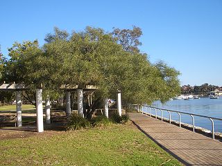
The Bay Run is a 7 kilometre-long pedestrian and cycling circuit around Iron Cove in the suburbs of Rozelle, Lilyfield, Haberfield, Five Dock and Drummoyne in the inner-west of Sydney, New South Wales, Australia. The Bay Run provides excellent views of Iron Cove for its entire course as it constantly hugs the shoreline. The Bay Run is popular with joggers, walkers, roller skaters and cyclists who enjoy the pleasant waterside scenery while exercising. The Bay Run plays host to the annual Bay Run fun run, a community event that brings people together in the name of health, fun and exercise.

UTS Haberfield Rowing Club in Sydney was formed as Haberfield Rowing Club in 1925. It has occupied its current site on Port Jackson's, Iron Cove at Dobroyd Point since 1926. The club had a senior and lightweight Sydney premiership & national competition focus until 1992 when it became aligned with the University of Technology, Sydney and since then it has also been a varsity club. Its elite program has enjoyed great success since the 1990s with a number of the club's oarsmen and women making Australian Olympic selection since then.

Lewisham Sewage Aqueduct is a heritage-listed sewage aqueduct in Gadigal Reserve, adjacent to 5 Grosvenor Crescent, Summer Hill, Inner West Council, Sydney, New South Wales, Australia. It was designed by Sewerage Construction Branch and Department of Public Works and built in 1900. The property is owned by Sydney Water. It was added to the New South Wales State Heritage Register on 18 November 1999.
