Hurlstone Park, New South Wales

Last updated

Hurlstone Park
Sydney,  New South Wales
HurlstonePark1.JPG
Crinan Street, Hurlstone Park
Hurlstone Park, New South Wales
Population4,692 (2016 census) [1]
Postcode(s) 2193 [2]
Elevation23 m (75 ft)
Location9 km (6 mi) inner-west of Sydney CBD
LGA(s)
State electorate(s) Canterbury
Federal division(s)
Suburbs around Hurlstone Park:
Ashfield Summer Hill Dulwich Hill
Ashbury Hurlstone Park Marrickville
Canterbury Earlwood Marrickville South

Hurlstone Park is a suburb in the Inner West of Sydney, New South Wales, Australia. Hurlstone Park is located nine kilometres south-west of the Sydney central business district and is mostly in the local government area of the City of Canterbury-Bankstown, and partly in the Inner West Council. The suburb is bounded by: the Cooks River to the south, Garnet Street to the east, New Canterbury Road to the north, Canterbury Road to the north-west, and Church Street to the west.

Contents

History

Hurlstone Park was first known as 'Wattle Hill' and then 'Fernhill'. After the Postmaster-General's Department refused to open a post office called Fernhill, a 1910 referendum chose the name 'Hurlstone', after the nearby Hurlstone College. John Kinloch founded the college in 1878, on the site of present-day Trinity Grammar School and named it after his mother's maiden name, which was Helen Hurlstone. The college moved to a new site, now known as Hurlstone Agricultural High School. The 'Park' was added at the request of the Railways Department, to avoid confusion with the New South Wales town of Hillston. [3]

Transport

Hurlstone Park railway station Hurlstone Park Railway Station November 2017.jpg
Hurlstone Park railway station

Hurlstone Park railway station is a Sydney Trains station (located 8.8 km from Central station) on the Bankstown line.

Transit Systems operate the following bus services in Hurlstone Park: 444; 445 (to Balmain East ferry wharf via Dulwich Hill, Petersham Lilyfield, Leichhardt and Rozelle), 428 (to the city via Canterbury, Dulwich Hill, Petersham, Marrickville and Newtown) and L28 routes which run along the Canterbury Road and New Canterbury Road boundary, and the 418 (to Burwood via Ashfield, and to Bondi Junction via Dulwich Hill, Marrickville, Sydenham, St Peters, Alexandria, Mascot, Rosebery, Eastlakes, Kingsford, Randwick and Queens Park), and 406 (to Five Dock via Ashfield) routes which pass through the suburb (along Crinan Street with a bus stop directly outside the railway station).

Commercial area

Floss Street, Hurlstone Park HurlstonePark2.JPG
Floss Street, Hurlstone Park

There is a group of shops around Hurlstone Park Station: along Crinan Street, the southern end of Duntroon Street and Floss Street. There are also commercial areas along Canterbury Road and New Canterbury Road. There is an active, local Chamber of Commerce: Canterbury-Hurlstone Park Chamber of Commerce.

The rest of the commercially used land in Hurlstone Park is made up of various shops, ranging from fast food outlets and milk bars to a couple of petrol stations. Hurlstone Park also has three childcare centres. Specific to Hurlstone Park village are the following businesses: three cafés, a seven-day supermarket, newsagent, lawyer, accountants, dry cleaner, laundry service, post office which opened in 1911, [4] doctor's surgery, dentist, shoe repair, real estate agent, naturopath, seven-day bottle shop, convenience store, three hairdressers, an Asian grocery store and two ATMs (one Commonwealth Bank and one Citibank). The locals and shop-owners in Hurlstone Park are well-acquainted. The local shoemaker still crafts bespoke shoes, and sells local honey.

Pubs and clubs

Canterbury Hurlstone Park RSL Club CanterburyHurlstoneParkRSLClub.jpg
Canterbury Hurlstone Park RSL Club
The former Bowling and Recreation Club HurlstonePark BowlingAndRecreationClub.jpg
The former Bowling and Recreation Club
The former Hurlstone Park Hotel on New Canterbury Road Hurlstone Park Hotel.jpg
The former Hurlstone Park Hotel on New Canterbury Road

Hurlstone Park contains the following clubs and pubs:

Houses

Victorian-era house in Hopetoun St, Hurlstone Park 19HopetounSt HurlstonePark.jpg
Victorian-era house in Hopetoun St, Hurlstone Park
West-ward view of the inlet known as "Boat Harbour". HurlstonePark BoatHarbour02 2010.jpg
West-ward view of the inlet known as "Boat Harbour".
East-ward view of Cooks River taken from the Foord Street footbridge. HurlstonePark CooksRiverFoordStreetFootbridgeEastView 2010.jpg
East-ward view of Cooks River taken from the Foord Street footbridge.

Hurlstone Park has a range of period homes. It is generally a low-rise residential area with maintained family homes and larger back-yards, with tree-lined streets, and small parks and playgrounds. Older shop façades, some with original features make up the small shopping strip. There is an increasing number of high-rise units in the suburb mostly along Canterbury and New Canterbury Roads. Some of the suburb is an oasis of heritage, with a village atmosphere valued by the residents it is potentially threatened by changes to zoning and increased high-rise development.[ citation needed ]

Parks and reserves

Hurlstone Park Uniting Church HurlstonePark UnitingChurch.jpg
Hurlstone Park Uniting Church
St Stephen Greek Orthodox Church StStephanos GreekOrthodoxChurch HurlstonePark.jpg
St Stephen Greek Orthodox Church
Hurlstone Park Vietnamese Baptist Church HurlstonePark VietnameseBaptistChurch corner.jpg
Hurlstone Park Vietnamese Baptist Church
Siddha Yoga Ashram, Garnet Street (1)Siddha Yoga Ashram Hurlstone Park Sydney.jpg
Siddha Yoga Ashram, Garnet Street

Hurlstone Park includes the following parks and reserves:

Churches and religion

According to the 2016 census, the top responses for religious affiliation in Hurlstone Park were No Religion 30.0%, Catholic 29.0%, Eastern Orthodox 11.2%, Not stated 9.2% and Anglican 5.1%. [1]

The suburb contains the following religious establishments:

Schools

The Edgeware School EdgewareSchool HurlstonePark.jpg
The Edgeware School

Only one school is located in Hurlstone Park. The Edgeware School [11] is an alternative Department of Education facility, mainly for year 9 to 12 students who have been unsuccessful in mainstream schools. It is located in Burnett street (just off Tennent parade).

Population

At the 2016 census, there were 4,692 residents in Hurlstone Park. 57.2% of people were born in Australia. The next most common countries of birth were Greece 4.5%, China 3.1%, Lebanon 2.7%, England 2.4% and Italy 2.3%. 54.9% of people spoke only English at home. Other languages spoken at home included Greek 9.4%, Arabic 5.1%, Mandarin 3.1%, Italian 3.1% and Portuguese 2.9%. The most common ancestries were English 16.1%, Australian 14.7%, Irish 8.9%, Greek 8.4% and Chinese 5.3%. [1]

Of occupied private dwellings in Hurlstone Park, 37.9% were owned outright, 30.0% were owned with a mortgage and 29.5% were rented. [1] Residents of Hurlstone Park value the safety and intimacy of their suburb. Many residents have lived here for decades.

Related Research Articles

Leichhardt, New South Wales Suburb of Sydney, New South Wales, Australia

Leichhardt is a suburb in the Inner West of Sydney, in the state of New South Wales, Australia. Leichhardt is located 5 kilometres west of the Sydney central business district (CBD) and is the administrative centre for the local government area (LGA) of the Inner West Council. The suburb is bordered by Haberfield to the west, Annandale to the east, Lilyfield to the north and Petersham, Lewisham and Stanmore to the south.

Ashfield, New South Wales Suburb of Sydney, New South Wales, Australia

Ashfield is a suburb in the Inner West of Sydney, in the state of New South Wales, Australia. Ashfield is about 8 kilometres west of the Sydney central business district.

Summer Hill, New South Wales Suburb of Sydney, New South Wales, Australia

Summer Hill is a suburb of Sydney, in the state of New South Wales, Australia. Summer Hill is located 7 kilometres west of the Sydney central business district, in the local government area of the Inner West Council.

Haberfield, New South Wales Suburb of Sydney, New South Wales, Australia

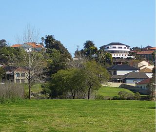
Haberfield is a suburb in the Inner West of Sydney, in the state of New South Wales, Australia. Haberfield is located 6.5 kilometres west of the Sydney central business district in the local government area of the Inner West Council.

Padstow, New South Wales Suburb of City of Canterbury-Bankstown, New South Wales, Australia

Padstow, a suburb of local government area City of Canterbury-Bankstown, is located 22 kilometres south-west of the Sydney central business district, in the state of New South Wales, Australia, and is a part of the South-western Sydney region. It is the easternmost suburb in Greater Western Sydney, bordering the Southern Sydney region to the east.

Marrickville, New South Wales Suburb of Sydney, New South Wales, Australia

Marrickville is a suburb in the Inner West and South Western Sydney, in the state of New South Wales, Australia. Marrickville is located 7 kilometres south-west of the Sydney central business district and is the largest suburb in the Inner West Council local government area.

Dulwich Hill, New South Wales Suburb of Sydney, New South Wales, Australia

Dulwich Hill is a suburb in the Inner West of Sydney, in the state of New South Wales, Australia. It is 7.5 kilometres south-west of the Sydney central business district, in the local government area of Inner West Council. Dulwich Hill stretches south to the shore of the Cooks River.

Canterbury, New South Wales Suburb of Sydney, New South Wales, Australia

Canterbury is a suburb extending across south-western Sydney and the Inner West, in the state of New South Wales, Australia. Canterbury is located 10.5 kilometres (6.5 mi) south-west of the Sydney central business district in the City of Canterbury-Bankstown.

Ashbury, New South Wales Suburb of Sydney, New South Wales, Australia

Ashbury is a suburb in the Inner West of Sydney, in the state of New South Wales, Australia. It lies in the local government area of City of Canterbury-Bankstown with some areas in the Inner West Council and is about 10 kilometres south-west of the Sydney central business district. The postcode is 2193, the same as neighbouring Canterbury and Hurlstone Park.

Undercliffe, New South Wales New South Wales, Australia

Undercliffe is an eastern section of the suburb of Earlwood located in South Western Sydney, New South Wales, Australia. Undercliffe is situated 10 kilometres south-west of the Sydney central business district within the local government area of the City of Canterbury-Bankstown.

Sans Souci, New South Wales Suburb of Sydney, New South Wales, Australia

Sans Souci is a southern Sydney suburb in the state of New South Wales, Australia. Sans Souci is 17 kilometres south of the Sydney central business district and lies across the local government areas of the Bayside Council and the Georges River Council. It is part of the St George area.

Milperra Suburb of Sydney, New South Wales, Australia

Milperra, a suburb of local government area City of Canterbury-Bankstown, is located 24 kilometres west of the Sydney central business district in the state of New South Wales, Australia, and is a part of the South Western Sydney region.

Kingsgrove Suburb of Sydney, New South Wales, Australia

Kingsgrove is a suburb in Southern Sydney, New South Wales, Australia. Kingsgrove is 13 kilometres (8.1 mi) south of the Sydney central business district and lies across the local government areas of the City of Canterbury-Bankstown, Bayside Council and the Georges River Council.

Campsie, New South Wales Suburb of Sydney, New South Wales, Australia

Campsie is a suburb in the state of New South Wales, Australia. Campsie is 11 kilometres south west of the Sydney central business district, on the southern bank of the Cooks River. Campsie is one of the administrative centres of the City of Canterbury-Bankstown.

Earlwood, New South Wales Suburb of Sydney, New South Wales, Australia

Earlwood is a suburb in South Western Sydney, in the state of New South Wales, Australia. Earlwood is located 10 kilometres south-west of the Sydney central business district, in the local government area of the City of Canterbury-Bankstown.

Croydon Park, New South Wales Suburb of Sydney, New South Wales, Australia

Croydon Park is a suburb in the Inner West of Sydney, in the state of New South Wales, Australia. Croydon Park is 10 kilometres south-west of the Sydney central business district and is divided between the local government areas of the City of Canterbury-Bankstown, Municipality of Burwood and Inner West Council. Croydon is a separate suburb, to the north.

Enfield, New South Wales Suburb of Sydney, New South Wales, Australia

Enfield is a suburb in the Inner West of Sydney, in the state of New South Wales, Australia. It is 11 kilometres south-west of the Sydney central business district in the local government area of Municipality of Burwood.

St Albans, New Zealand Suburb of Christchurch in Christchurch City Council, New Zealand

St Albans is a large, inner-northern suburb of Christchurch, New Zealand, located directly north of the Christchurch Central Business District. It is the second largest suburb in the city by population, with a population of 13,137 at the 2018 Census. The suburb falls within the Christchurch Central electorate and is represented by Duncan Webb, who has been the member of parliament since the 2017 general election. St Albans is one of the most diverse residential neighbourhoods in Christchurch, with a wide range of densities, architectural styles and housing ages throughout the suburb. It has everything from run-down high-density council-owned flats, to modern luxurious high-density flats and apartments; old mid-density workers cottages through to large low-density estates of various ages.

Canterbury-Bankstown Region in New South Wales, Australia

Canterbury-Bankstown is a customary region of Sydney, Australia, in the south-western suburbs. The area is located around the Bankstown railway line, to the west of the St George region and to the south of the Inner West region. The suburbs of the Canterbury-Bankstown region are not specific to the local government area of the City of Canterbury-Bankstown, but includes many of them. The Georges River acts as the southern boundary of this region and the Cooks River the northern boundary. The region lies on the eastern reaches of the Cumberland Plain.

Canterbury District Soccer Football Association

Canterbury District Soccer Football Association is a governing body and football (soccer) competition located in the Canterbury suburbs of Sydney. Its administrative headquarters are located at Pratten Park Bowls, Ashfield, New South Wales. All competitions and football activity is under control of Football New South Wales. The District Association consists of ten all ages competitions which corresponds to tiers six to fifteen on the Australian soccer pyramid. Clubs are located in the Burwood, Canada Bay, Canterbury-Bankstown, Inner West and Strathfield local council areas.

References

  1. 1 2 3 4 Australian Bureau of Statistics (27 June 2017). "Hurlstone Park (State Suburb)". 2016 Census QuickStats. Retrieved 10 October 2017. OOjs UI icon edit-ltr-progressive.svg
  2. Hurlstone Park Postcode Australia Post
  3. Book of Sydney Suburbs, Frances Pollon (Angus and Robertson) 1990
  4. Phoenix Auction History, Post Office List , retrieved 29 March 2021
  5. "Canterbury-Hurlstone Park RSL Memorial Chapel". Register of War Memorials in New South Wales.
  6. "Hurlstone Park Wanderers". Archived from the original on 15 September 2009.
  7. "City of Canterbury – Euston Park War Memorial". Canterbury.nsw.gov.au. Archived from the original on 27 February 2011. Retrieved 9 August 2010.
  8. "Euston Memorial". Register of War Memorials in New South Wales.
  9. "Ryde to Botany Bay cycleway". Canterbury.nsw.gov.au. 16 February 2010. Archived from the original on 29 June 2011. Retrieved 9 August 2010.
  10. "Siddha Yoga Ashram". Siddhayoga.org.au. Archived from the original on 14 August 2010. Retrieved 9 August 2010.
  11. "Edgeware School". Edgeware-s.schools.nsw.edu.au. Retrieved 9 August 2010.

Coordinates: 33°54′38″S151°07′45″E / 33.91058°S 151.12919°E / -33.91058; 151.12919