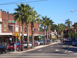
Lewisham, New South Wales

Last updated

Lewisham
Sydney,  New South Wales
LewishamNSWAerial1930s.jpg
Aerial photograph of Lewisham in the 1930s showing from left, the railway line, Lewisham Hospital and Petersham Park
Lewisham, New South Wales
Map
Population4,060 (SAL 2021) [1]
Postcode(s) 2049
Elevation22 m (72 ft)
Area0.64 km2 (0.2 sq mi)
Location7 km (4 mi) south-west of Sydney CBD
LGA(s) Inner West Council
State electorate(s)
Federal division(s) Grayndler
Suburbs around Lewisham:
Haberfield Leichhardt Leichhardt
Summer Hill Lewisham Petersham
Dulwich Hill Dulwich Hill Marrickville

Lewisham is a suburb in the Inner West [2] of Sydney, in the state of New South Wales, Australia. Lewisham is located 7 kilometres south-west of the Sydney central business district, in the local government area of Inner West Council.

Contents

History

Lewisham took its name in 1834 from the estate of Joshua Frey Josephson, a German-born businessman who would later become mayor of Sydney. [3] The estate was named after the London borough of Lewisham, which means Leofsa's village or manor. [4]

The original residents of the Lewisham area were the Cadigal clan of the Darug tribe. Artefacts found near the Cooks River indicate at least 7,000 years of habitation in the local area. [5] When the First Fleet arrived in 1788, the settlers set up camp in the middle of Cadigal territory. While the first governor Arthur Phillip tried to establish cordial relations with the Cadigals and their neighbours, the two groups were competing for the same food sources and tensions inevitably developed. In 1789, a smallpox epidemic wiped out the majority of the Cadigals. [6] By 1809, all the land within Lewisham had been granted.

Heritage listings

Lewisham has a number of heritage-listed sites, including:

Transport

2104 departing Lewisham West.jpg
Light rail service departing Lewisham West station
LewishamRailwayStation1.JPG
Lewisham railway station

Lewisham railway station is on the Inner West & Leppington Line of the Sydney Trains network. This provides access to Sydney CBD, the interchange station of Strathfield and the commercial centres of Burwood, Newtown and Parramatta.

Lewisham is notable in railway history as the termination point for the first train journey in the NSW colony in 1855, although the railway station was not built until 1885. The whipple truss bridge over Long Cove Creek was constructed 1885-1886 featuring North American technology developed by Squire Whipple. [10] It is probably the most significant railway bridge site in Australia, certainly in NSW. It has the unique distinction of four different types of bridges from different eras. Engineers Australia designated the Viaduct in 1994 as an historic engineering marker.

There are two stations serving Lewisham on the Inner West Light Rail. These are Lewisham West, adjacent to the former flour mill on the border with Summer Hill, and Taverners Hill, near Parramatta Road. Access to the city is quicker by conventional train, but the light rail may be used for some cross-regional journeys. It also interchanges with Dulwich Hill railway station on the Bankstown Line.

The 413 bus service, between Campsie and the city, cuts through the middle of Lewisham and provides an interchange with the railway station. Several bus services (461 - Burwood to the city, 480 & 483 - Strathfield to the city) run along Parramatta Road. These interchange with the Taverners Hill stop. The other bus corridor is along New Canterbury Rd. This is served by the 428/L28 from Canterbury to the city via Newtown and route 445 from Campsie to Balmain. [11]

Schools

A Trinity Grammar School Infants School was opened in February 2006 at 5 Thomas Street, Lewisham. [12] The site was formerly Saint Thomas Becket Primary School which was founded in 1855 by the Sisters of Mercy. The school was originally for girls but became co-ed in the 1950s. Christian Brothers' High School is located on 58 - 61 The Boulevarde. Lewisham Public School is located on 71 The Boulevarde Lewisham. Petersham Public School is on the border of Lewisham and Petersham, the John Berne School (formerly the Berne Education Centre) and the Catholic Intensive English Centre are located on the site of the former St Thomas Boys High School, which closed in 1997.[ citation needed ]

Churches

St. Thomas Becket's Church Lewisham St Thomas Becket's Church.jpg
St. Thomas Becket's Church Lewisham

Saint Thomas Becket's Catholic church is located in Thomas Street. The current priest is Fr. Gerald Gleeson. The Servants of Mary Help of Christians operated its Marian Centre from St Thomas Becket Primary School Hall. It is now at 2 Missenden Rd, Camperdown, NSW 2049, operating from St. Joseph's church.

Lewisham is also the home of the Maternal Heart of Mary Latin Mass Parish, a Personal Parish for the celebration of the Extraordinary Form of the Roman Rite, of which Fr Duncan Wong FSSP is the Parish Priest. The church is situated behind St Thomas Becket's, on Charles O'Neill Way.


NASA image of Sydney's CBD and inner west suburbs, with borders of Lewisham shown in orange LewishamNSWsatellite.jpg
NASA image of Sydney's CBD and inner west suburbs, with borders of Lewisham shown in orange

Demographics

Lewisham's population was shown as 3,164 in the 2016 census [13] and had risen to 4,060 in the 2021 census. [14]

According to the 2011 census, Lewisham had a population of 2927. The character of its population was different from neighbouring suburbs, by having a smaller proportion of residents born overseas. After Australia, the most common countries of birth were England (4.0%), New Zealand (2.5%) and Portugal (1.8%). There were also a reasonable number of Greek (3.2%), and Portuguese (2.3%) speakers, who were the most common languages in the area after English. Indigenous Australians numbered 32 people (1.1%) which was less than the state and national figures. [15]

The population had a greater proportion of people in de facto relationships and a smaller proportion of people in registered marriages than the New South Wales and Australian figures. It had a greater proportion of people stating that they had no religion (33.4%) but fewer Anglicans (9.5%) than the state and national figures, while the proportion of Roman Catholics (25.9%) was lower than New South Wales (27.5%) but slightly higher than the national figures (25.3%). [15]

Notable residents

Related Research Articles

<span class="mw-page-title-main">Circular Quay</span> Locality in Sydney, New South Wales, Australia

Circular Quay is a harbour, former working port and now international passenger shipping terminal, public piazza and tourism precinct, heritage area, and transport node located in Sydney, New South Wales, Australia on the northern edge of the Sydney central business district on Sydney Cove, between Bennelong Point and The Rocks. It is part of the local government area of the City of Sydney.

<span class="mw-page-title-main">Inner West</span> Region in New South Wales, Australia

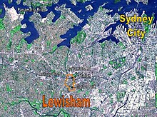
The Inner West of Sydney is an area directly west of the Sydney central business district, New South Wales, Australia. The suburbs that make up the Inner West are predominantly located along the southern shore of Port Jackson, stretching south to the shores of the Cooks River. The western boundary of the Inner West is approximately the A3 arterial road, which divides the Inner West from the Greater Western Sydney region. The Inner West is much larger than the Inner West Council local government area. The Inner West roughly corresponds with the Parish of Petersham and Parish of Concord, two cadastral divisions used for land titles.

<span class="mw-page-title-main">Summer Hill, New South Wales</span> Suburb of Sydney, New South Wales, Australia

Summer Hill is a suburb of Sydney, in the state of New South Wales, Australia. Summer Hill is located 7 kilometres west of the Sydney central business district, in the local government area of the Inner West Council.

<span class="mw-page-title-main">Haberfield, New South Wales</span> Suburb of Sydney, New South Wales, Australia

Haberfield is a suburb in the Inner West of Sydney, in the state of New South Wales, Australia. Haberfield is located 6.5 kilometres west of the Sydney central business district in the local government area of the Inner West Council.

<span class="mw-page-title-main">Strathfield, New South Wales</span> Suburb of Sydney, New South Wales, Australia

Strathfield is a suburb in the Inner West of Sydney, in the state of New South Wales, Australia. It is located 12 kilometres west of the Sydney central business district and is the administrative centre of the Municipality of Strathfield. A small section of the suburb north of the railway line lies within the City of Canada Bay, while the area east of The Boulevard lies within the Municipality of Burwood. North Strathfield and Strathfield South are separate suburbs to the north and south, respectively.

<span class="mw-page-title-main">Marrickville, New South Wales</span> Suburb of Sydney, New South Wales, Australia

Marrickville is a suburb in the Inner West of Sydney, in the state of New South Wales, Australia. Marrickville is located 7 kilometres south-west of the Sydney central business district and is the largest suburb in the Inner West Council local government area.

<span class="mw-page-title-main">Wangal</span> Ethnic group of indigneous Australians

The Wangal people are a clan of the Dharug (?) Aboriginal people whose heirs are custodians of the lands and waters of what is now the Inner West of Sydney, New South Wales, centred around the Municipality of Strathfield, Municipality of Burwood, City of Canada Bay and former Ashfield Council and extending west into the City of Parramatta.

<span class="mw-page-title-main">Dulwich Hill</span> Suburb of Sydney, New South Wales, Australia

Dulwich Hill is a suburb in the Inner West of Sydney, in the state of New South Wales, Australia. It is 7.5 kilometres south-west of the Sydney central business district, in the local government area of Inner West Council. Dulwich Hill stretches south to the shore of the Cooks River.

<span class="mw-page-title-main">Petersham, New South Wales</span> Suburb of Sydney, New South Wales, Australia

Petersham is a suburb in the Inner West of Sydney, in the state of New South Wales, Australia. Petersham is located 6 kilometres south-west of the Sydney central business district, in the local government area of Inner West Council. Petersham is known for its extensive Portuguese commercial offerings, with many Portuguese businesses and restaurants, although only 156 (1.9%) of the population was actually born in Portugal.

<span class="mw-page-title-main">Stanmore, New South Wales</span> Suburb of Sydney, New South Wales, Australia

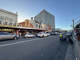
Stanmore is a suburb in the Inner West of Sydney, in New South Wales, Australia 6 kilometres south west of the Sydney central business district. It is part of the local government area of the Inner West Council. It is known for its long strip of shops running along Parramatta Road.

<span class="mw-page-title-main">Croydon, New South Wales</span> Suburb of Sydney, New South Wales, Australia

Croydon is a suburb in the Inner West of Sydney, in the state of New South Wales, Australia. It is located 9 kilometres (5.6 mi) west of the Sydney central business district. Croydon is split between the two local government areas of Municipality of Burwood and the Inner West Council.

<span class="mw-page-title-main">Erskineville</span> Suburb of Sydney, New South Wales, Australia

Erskineville is a suburb in the Inner West of Sydney, New South Wales, Australia. It is located 6 kilometres south west of the Sydney central business district and is part of the local government area of the City of Sydney. Erskineville is a diverse suburb homing to a wide variety of ethnicity from its varying Southeast Europe and Aboriginal community. Erskineville is colloquially known as Erko.

<span class="mw-page-title-main">Marrickville Council</span> Former local government area in New South Wales, Australia

Marrickville Council was a local government area located in the Inner West region of Sydney, Australia. It was originally created on 1 November 1861 as the "Municipality of Marrickville". On 12 May 2016, Marrickville Council was forcibly merged with Ashfield and Leichhardt councils into the newly formed Inner West Council.

<span class="mw-page-title-main">Sydenham, New South Wales</span> Suburb of Sydney, New South Wales, Australia

Sydenham is a suburb in the Inner West of Sydney, in the state of New South Wales, Australia. Sydenham is located 8 kilometres south of Sydney central business district and is part of the local government area of Inner West Council. Sydenham is surrounded by the suburbs of Marrickville, St Peters and Tempe.

<span class="mw-page-title-main">St Peters, New South Wales</span> Suburb of Sydney, New South Wales, Australia

St Peters is a suburb in the Inner West of Sydney, in the state of New South Wales, Australia. It is 7 kilometres south of the Sydney central business district, in the local government area of Inner West Council, with a small section in the southeast in the City of Sydney.

<span class="mw-page-title-main">Earlwood, New South Wales</span> Suburb of Sydney, New South Wales, Australia

Earlwood is a suburb of Sydney, in the state of New South Wales, Australia. Earlwood is located 10 kilometres south-west of the Sydney central business district, and is part of the Canterbury-Bankstown area. It is in the local government area of the City of Canterbury-Bankstown.

The Gadigal, also spelled as Cadigal and Caddiegal, are a group of Aboriginal people whose traditional lands are located in Gadi, on Eora country, the location of Sydney, New South Wales, Australia.

<span class="mw-page-title-main">Inner West Council</span> Local government area in New South Wales, Australia

Inner West Council is a local government area located in the inner western region of Sydney in the state of New South Wales, Australia. The council makes up the eastern part of this wider region, and was formed on 12 May 2016 from the merger of the former Ashfield, Leichhardt and Marrickville councils.

<span class="mw-page-title-main">Lewisham Sewage Aqueduct</span> Historic site in New South Wales, Australia

Lewisham Sewage Aqueduct is a heritage-listed sewage aqueduct in Gadigal Reserve, adjacent to 5 Grosvenor Crescent, Summer Hill, Inner West Council, Sydney, New South Wales, Australia. It was designed by Sewerage Construction Branch and Department of Public Works and built in 1900. The property is owned by Sydney Water. It was added to the New South Wales State Heritage Register on 18 November 1999.
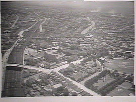
<span class="mw-page-title-main">Long Cove Creek railway viaducts, Lewisham</span> Bridge in New South Wales, Australia

The Long Cove Creek railway viaducts are heritage-listed railway viaducts which carry the Main Suburban railway line over Long Cove Creek between the suburbs of Lewisham and Summer Hill in Sydney, New South Wales, Australia. The viaducts were designed and built by the New South Wales Government Railways. The property is owned by Transport Asset Holding Entity, an agency of the Government of New South Wales. It was added to the New South Wales State Heritage Register on 2 April 1999.

References

  1. Australian Bureau of Statistics (28 June 2022). "Lewisham (NSW) (suburb and locality)". Australian Census 2021 QuickStats. Retrieved 28 June 2022.  OOjs UI icon edit-ltr-progressive.svg
  2. Australian Suburb Guide: Sydney Inner West Archived 26 December 2012 at the Wayback Machine Retrieved 8 August 2013.
  3. Josephson, Joshua Frey (1815–1892). Australian Dictionary of Biography Online. Retrieved 17 April 2008.
  4. "History of Suburbs". Marrickville Council. Archived from the original on 24 December 2008. Retrieved 17 April 2008.
  5. "Our Local History". Marrickville Council. Retrieved 17 April 2008.
  6. "Cadigal Wangal - Smallpox Epidemic". Marrickville Council. Retrieved 17 April 2008.
  7. "Lewisham Railway viaducts over Long Cove Creek". New South Wales State Heritage Register . Department of Planning & Environment. H01043. Retrieved 18 May 2018. CC BY icon.svg Text is licensed by State of New South Wales (Department of Planning and Environment) under CC-BY 4.0 licence .
  8. "Sewer Vent". New South Wales State Heritage Register . Department of Planning & Environment. H01640. Retrieved 18 May 2018. CC BY icon.svg Text is licensed by State of New South Wales (Department of Planning and Environment) under CC-BY 4.0 licence .
  9. "Lewisham Sewage Aqueduct". New South Wales State Heritage Register . Department of Planning & Environment. H01326. Retrieved 28 May 2018. CC BY icon.svg Text is licensed by State of New South Wales (Department of Planning and Environment) under CC-BY 4.0 licence .
  10. Some Notes on Lewisham Viaduct Australian Railway Historical Society Bulletin, June, 1942 pp72-73
  11. Sydney Inner West/South Guide Transit Systems
  12. "Trinity Grammar School Pre-Kindergarten". Trinity Grammar School. Trinity Grammar School. Archived from the original on 8 August 2014. Retrieved 3 August 2014.
  13. Australian Bureau of Statistics (27 June 2017). "Lewisham (State Suburb)". 2016 Census QuickStats. Retrieved 14 March 2018. OOjs UI icon edit-ltr-progressive.svg
  14. "2021 Lewisham (NSW), Census All persons QuickStats". Australian Bureau of Statistics. Retrieved 14 August 2022.
  15. 1 2 Australian Bureau of Statistics (31 October 2012). "Lewisham (State Suburb)". 2011 Census QuickStats. Retrieved 29 March 2015. OOjs UI icon edit-ltr-progressive.svg
  16. Shand, John Wentworth (1897–1959). Australian Dictionary of Biography Online. Retrieved 17 April 2008.
  17. Lynch, Annie [Mother Xavier] (1870–1938) Biographical Entry - Australian Dictionary of Biography Online

33°53′42″S151°08′40″E / 33.8949°S 151.144415°E / -33.8949; 151.144415