Central is a heritage-listed railway station located in the centre of Sydney, New South Wales, Australia. The station is the largest and busiest railway station in Australia and serves as a major transport interchange for NSW TrainLink inter-city rail services, Sydney Trains commuter rail services, Sydney light rail services, bus services, and private coach transport services. The station is also known as Sydney Terminal. The property was added to the New South Wales State Heritage Register on 2 April 1999. It recorded 85.4 million passenger movements in 2018 and serves over 250,000 people daily.

The Sydney light rail network is a light rail/tram system serving the city of Sydney, New South Wales, Australia. The network currently consists of three passenger routes, the L1 Dulwich Hill, L2 Randwick and L3 Kingsford lines. The network comprises 42 stops and a system length of 24.7 km (15.3 mi), making it the second largest light rail network in Australia behind the tram network in Melbourne, Victoria. A fourth line, the 12 km (7.5 mi) Parramatta Light Rail in Sydney's west, is currently under construction and planned to open in May 2024.
Lilyfield is a suburb in the Inner West of Sydney, in the state of New South Wales, Australia. Lilyfield is located 6 kilometres west of the Sydney central business district, in the local government area of the Inner West Council.

Salisbury railway station serves the city of Salisbury in Wiltshire, England. It is 83 miles 43 chains (134.4 km) from London Waterloo on the West of England line to Exeter St Davids. This is crossed by the Wessex Main Line from Bristol Temple Meads to Southampton Central. The station is operated and served by South Western Railway (SWR), and is also served by Great Western Railway (GWR).
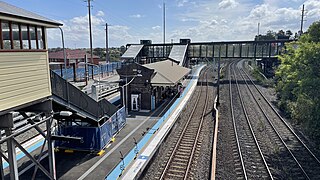
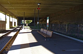
Dulwich Hill railway station is located on the Bankstown line, serving the Sydney suburb of Dulwich Hill. It is served by Sydney Trains T3 Bankstown line services.
City West Link is a 5.0-kilometre (3.1 mi) link road connecting Parramatta Road and the Western Distributor through the Inner West suburbs of Sydney, New South Wales, Australia. It was bypassed by the WestConnex project upon its completion in November 2023. This name covers a few consecutive roads and is widely known to most drivers, but the entire allocation is also known – and signposted – by the names of its constituent parts: Wattle Street, Dobroyd Parade, City West Link proper and The Cresent.

The Sydney tramway network served the inner suburbs of Sydney, Australia, from 1879 until 1961. In its heyday, it was the largest in Australia, the second largest in the Commonwealth of Nations, and one of the largest in the world. The network was heavily worked, with about 1,600 cars in service at any one time at its peak during the 1930s . Patronage peaked in 1945 at 405 million passenger journeys. Its maximum street trackage totalled 291 km in 1923.

Wrexham Central railway station is the smaller of two railway stations serving the central area of Wrexham in Wales, the other being Wrexham General. The platform can accommodate a three car diesel train, but has room for platform extension. It is the southern terminus of the Borderlands Line, also known as the Wrexham-Bidston line, which links north-east Wales to Merseyside.

The M4 Motorway is a 55-kilometre (34 mi) series of partially-tolled dual carriageway motorways in Sydney, New South Wales designated as route M4. The M4 designation is part of the wider A4 and M4 route designation, the M4 runs parallel and/or below ground to Great Western Highway, Parramatta Road and City West Link, which are part of route A44.

The Sydney Freight Network is a network of dedicated railway lines for freight in Sydney, Australia, linking the state's rural and interstate rail network with the city's main yard at Enfield and Port Botany. Its primary components are the Southern Sydney Freight Line (SSFL) and a line from Sefton to Enfield and Port Botany. The Network has been managed by the Australian Rail Track Corporation (ARTC) since 2012. Prior to the completion of the SSFL, it was managed by RailCorp as the Metropolitan Freight Network.

Sydney, the largest city in Australia, has an extensive network of passenger and freight railways. The passenger system includes an extensive suburban railway network, operated by Sydney Trains, a metro network and a light rail network. A dedicated freight network also exists. Future expansion of the light rail network includes the Parramatta Light Rail. Existing light rail services are the Inner West Light Rail and the CBD & South East Light Rail.
WestConnex is a 33-kilometre (21 mi) predominantly underground motorway scheme in Sydney, New South Wales, Australia. A joint project of the New South Wales and Federal governments, the motorway scheme created around 26 kilometres (16 mi) of new tunnels between Homebush and Kingsgrove, passing underneath Inner West suburbs including Haberfield and St Peters. The first of the tunnels, the M4 East, opened to traffic in July 2019. The second of the tunnels, the M8 Motorway, opened to traffic a year later in July 2020. The third of the tunnels which extend the M4 and M8 opened to traffic in January 2023. The final component of the scheme, the Rozelle Interchange, opened to traffic in November 2023.
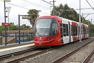
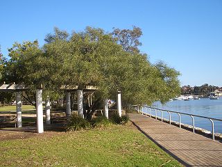
The Inner West Light Rail is a 12.8-kilometre (8.0 mi) light rail line in Sydney, New South Wales, Australia, running from Central railway station through the Inner West to Dulwich Hill and serving 23 stops. It is the original line of the Sydney light rail network, and was originally known as Sydney Light Rail. Light rail services on the line are now branded as the L1 Dulwich Hill Line.
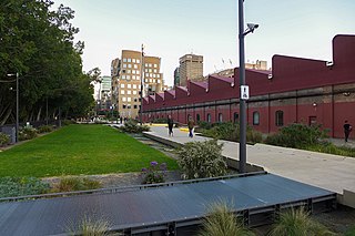
The Goods Line is an 800 m-long (2,625 ft) linear park and shared pedestrian pathway and cycleway in the suburb of Ultimo, in the City of Sydney, New South Wales, Australia. The corridor connects Railway Square to Darling Harbour in the south and passes both the University of Technology Sydney Broadway campus and the Australian Broadcasting Corporation Sydney head office. The Goods Line terminates in the north at the corner of Sussex and Hay Streets, in the Sydney central business district.
The 2010s saw many developments relating to transport in the Australian city of Sydney, New South Wales. The decade saw a substantial investment in infrastructure, including a new airport, motorway projects, light rail lines, Australia's first metro system, the new Waratah fleet and the demise of the non-air conditioned S sets from the rail network. Planning and branding of public transport services became substantially more centralised.

The Glebe and Wentworth Park railway viaducts are a series of two heritage-listed railway bridges and arch viaducts that carry the Inner West Light Rail across Wentworth Park, Jubilee Park, and Johnstons Creek in the inner western Sydney suburb of Glebe in the City of Sydney local government area of New South Wales, Australia. They were designed by the New South Wales Government Railways and built from 1892 to 1922 by day labour. They are also known as Wentworth Park Viaduct, Jubilee Park Viaduct and Glebe Viaducts. The viaducts were added to the New South Wales State Heritage Register on 2 April 1999.

The Railway Square road overbridge is a heritage-listed road overbridge carrying George Street over the former Darling Harbour goods railway line at Railway Square in the Sydney central business district, in the City of Sydney local government area of New South Wales, Australia. The property was added to the New South Wales State Heritage Register on 2 April 1999.
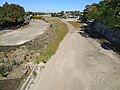
Darling Harbour Yard was a goods railway yard in Darling Harbour, New South Wales, Australia. The yard was once the origin of all outgoing goods traffic from Sydney. It was one of two major yards on the former Metropolitan Goods line, the other being in Rozelle. After closing to heavy rail in 1993, the alignment of the Metropolitan Goods line which passed through it was reutilised by light rail. The precinct around the yard was significantly redeveloped in the decades following its closure.

The M8 Motorway is a 15.2-kilometre (9.4 mi) tolled dual carriageway motorway in Sydney, New South Wales that is designated the M8 route marker. It consists predominantly of tunnels and includes tunnel connections to the future Western Harbour Tunnel and the M6 Motorway.
The Rozelle Interchange is an underground motorway interchange in Sydney, New South Wales, Australia. It was built as part of WestConnex and opened to traffic on 26 November 2023. The interchange also includes a toll-free bypass of Victoria Road between the Iron Cove Bridge and the Anzac Bridge known as the Iron Cove Link.