
Darling Harbour is a harbour adjacent to the city centre of Sydney, New South Wales, Australia that is made up of a large recreational and pedestrian precinct that is situated on western outskirts of the Sydney central business district.

Docklands, is an inner-city suburb in Melbourne, Victoria, Australia on the western end of the central business district. Docklands had a population of 15,495 at the 2021 census.

The Sydney light rail network is a light rail/tram system serving the city of Sydney, New South Wales, Australia. The network currently consists of three passenger routes, the L1 Dulwich Hill, L2 Randwick and L3 Kingsford lines. The network comprises 42 stops and a system length of 24.7 km (15.3 mi), making it the second largest light rail network in Australia behind the tram network in Melbourne, Victoria. A fourth line, the 12 km (7.5 mi) L4 in Sydney's west, is planned to open in late 2024.

Glebe is an inner-western suburb of Sydney in New South Wales. Glebe is located 3 kilometres (1.9 mi) southwest of the Sydney central business district in the Inner West region.
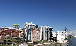
Pyrmont is an inner-city suburb of Sydney, in the state of New South Wales, Australia 2 kilometres south-west of the Sydney central business district in the local government area of the City of Sydney. It is also part of the Darling Harbour region.

The Glebe Island Bridge is a heritage-listed disused swing Allan truss road bridge that carried Victoria Road across Johnstons Bay, located in the inner city Sydney suburb of Pyrmont in the City of Sydney local government area of New South Wales, Australia. The bridge, that connected Rozelle to Pyrmont by road, is one of the last remaining swing bridges of its type in Australia and in the world. It was designed by Percy Allan and built from 1899 to 1903 by Bridges Branch of NSW Public Works Department. It is also known as RMS Bridge No. 61. It was added to the New South Wales State Heritage Register on 29 November 2013 and was listed on the Register of the National Estate on 19 April 1989.
The Sydney Monorail was a single-loop monorail in Sydney, that connected Darling Harbour, Chinatown and the Sydney central business and shopping districts. It opened in July 1988 and closed in June 2013.

White Bay is a bay on Sydney Harbour with a surrounding locality near the suburbs of Balmain and Rozelle in the Inner West of Sydney, New South Wales, Australia.

The Sydney Freight Network is a network of dedicated railway lines for freight in Sydney, Australia, linking the state's rural and interstate rail network with the city's main yard at Enfield and Port Botany. Its primary components are the Southern Sydney Freight Line (SSFL) and a line from Sefton to Enfield and Port Botany. The Network has been managed by the Australian Rail Track Corporation (ARTC) since 2012. Prior to the completion of the SSFL, it was managed by RailCorp as the Metropolitan Freight Network.

Sydney, the largest city in Australia, has an extensive network of passenger and goods railways. The passenger system includes an extensive suburban railway network, operated by Sydney Trains, a metro system and a light rail network. A dedicated goods network also exists.

Barangaroo is an area of central Sydney, Australia. It is at the north-western edge of the Sydney central business district and the southern end of the Sydney Harbour Bridge. It is part of the local government area of the City of Sydney. The area was used for fishing and hunting by Indigenous Australians prior to colonial settlement. The area is inclusive of The Hungry Mile, the name harbourside workers gave to the docklands area of Darling Harbour East during The Great Depression, where workers would walk from wharf to wharf in search of a job, often failing to find one.
Various railway lines have been proposed for Sydney, Australia, including both heavy rail extensions to the dominant suburban network, and more recently proposals for metro lines – one of which was completed in 2019. There have been various proposed light rail expansions, which are covered separately.

Glebe Island was a major port facility in Sydney Harbour and, in association with the adjacent White Bay facility, was the primary receiving venue for imported cars and dry bulk goods in the region until 2008. It is surrounded by White, Johnstons, and Rozelle Bays. Whilst retaining its original title as an "island", it has long been infilled to the shoreline of the suburb of Rozelle and connected by the Glebe Island Bridge to Pyrmont.
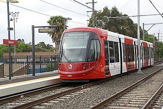
The Inner West Light Rail is a 12.8-kilometre (8.0 mi) light rail line in Sydney, New South Wales, Australia, running from Central railway station through the Inner West to Dulwich Hill and serving 23 stops. It was the original line of the Sydney light rail network. Services on the line are branded as the L1 Dulwich Hill Line since 2014.
Sydney Metro West is a rapid transit underground rail project currently under construction in Sydney, New South Wales, Australia. It involves constructing a rail line from Hunter St in the northern Sydney City Centre (CBD) to Westmead in the western suburbs of Greater Sydney. The new underground railway line will generally run parallel to the existing Main Suburban and Main Western railway lines, but via different suburbs and different stations, with the main aims being the doubling of rail capacity between the City Centre and Greater Western Sydney and the relief of overcrowding on the Western Line. The line will form part of the Sydney Metro system. Early construction began in 2020, with tunnelling starting in 2023. The line is anticipated to open from 2032.
The 2010s saw many developments relating to transport in the Australian city of Sydney. The decade saw a substantial investment in infrastructure, including a new airport, motorway projects, light rail lines, Australia's first metro system, the new Waratah fleet and the demise of the non-air conditioned S sets from the rail network. Planning and branding of public transport services became substantially more centralised.

The Glebe and Wentworth Park railway viaducts are a series of two heritage-listed railway bridges and arch viaducts that carry the Inner West Light Rail across Wentworth Park, Jubilee Park, and Johnstons Creek in the inner western Sydney suburb of Glebe in the City of Sydney local government area of New South Wales, Australia. They were designed by the New South Wales Government Railways and built from 1892 to 1922 by day labour. They are also known as Wentworth Park Viaduct, Jubilee Park Viaduct and Glebe Viaducts. The viaducts were added to the New South Wales State Heritage Register on 2 April 1999.

Rozelle Yard was a goods railway yard in Rozelle, New South Wales, Australia. It was one of two major yards on the Rozelle–Darling Harbour Goods Line, the other being in Darling Harbour. After heavy rail traffic ceased, part of the site was redeveloped into the Lilyfield Maintenance Depot of Sydney Light Rail. Other parts of the former yard were redeveloped into Rozelle Interchange and the Rozelle Parklands.

The urban renewal of Sydney is an ongoing land redevelopment process that is creating and reviving new urban centres across Sydney, Australia. Urban renewal refers to the refurbishment of derelict buildings, streets or neighbourhoods and is accompanied with the process of gentrification attributed by changes in land use and deindustrialisation of areas. In 2020, there are several projects underway and planned including Barangaroo, The Bays Precinct and Green Square.

The Rozelle–Darling Harbour Goods Line is a former heavy rail goods line in Sydney, Australia, now forming the bulk of the Inner West Light Rail. It was part of the city's goods railway network; through conversion to light rail, most of the former goods line was subsumed by the Sydney Light Rail network. A section of the line became a pedestrian pathway in inner Sydney.
