Brenan Park

Last updated

Brenan Park
Brenanpark.jpg
Brenan Park entrance sign
Brenan Park
Type Urban park, sports ground, nature reserve
Location Smithfield, Western suburbs of Sydney, New South Wales, Australia
Coordinates 33°51′29″S150°55′48″E / 33.8581°S 150.9300°E / -33.8581; 150.9300
Area20 hectares (49 acres)
Opened1981 (1981)
Etymology John Ryan Brenan
Operated by Fairfield City Council
Open24 hours
StatusOpen all year

Brenan Park is a 20-hectare (49-acre) urban park situated in the western suburbs of Sydney, New South Wales, Australia. [1] Primarily categorised as a sports field, the reserve contains an open grassland, bushland and recreational areas within the vicinity of native plants, such as eucalyptus trees. It is named after John Ryan Brenan, who founded the suburb of Smithfield in 1836.

Contents

Artificially terraced, Brenan Park was established in the early 1980s and it is one of the largest reserves in the City of Fairfield, and one of the largest non-golf course green spaces in the Western Sydney region. [2]

History

The shape of Brenan Park appears on the first survey design, in 1838, of the market town sketched for John Ryan Brenan. [3] Brenan Park was planned to be a housing subdivision and a market area in 1938, with its triangular shape fashioned to take advantage of the topography and views of the surrounding district. The housing subdivision was never constructed. The site was used as a sewage disposal depot and landfill until 1980, where it was proclaimed as unhealthy building land in 1981. Subsequently, it was re-landscaped and eventually developed into a reserve. [4]

Geography

The reserve is located in the suburb of Smithfield, and is bordered by Cumberland Highway, Brenan and Bourke Streets, which all give good passive surveillance opportunities from close residences and contiguous roads. The park's surrounds are mainly single-story houses. [5]

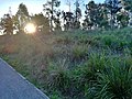
Brenan Park is in an elevated and weather-exposed location, with the highest areas being 44 metres (144 ft) AHD and those near the Cumberland Highway at 32 metres (105 ft). The elevated regions in the park are situated alongside Bourke Street, where they would provide a panoramic view of the greater western Sydney area and even the Sydney central business district. [6]

Ecology

Indigenous trees and shrubs are abundant in the park, with dominant vegetation species being Melaleuca quinquenervia (near the tennis courts), Eucalyptus moluccana (near the car park in Brenan Street), Casuarina glauca , Callistemon viminalis , Paperbark, Acacia , Lomandra and Eucalyptus bosistoana , most of which have large canopies that provide shade. [7]

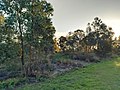
The boundary along the top part of Bourke Street and near Cumberland Highway is thickly planted with an avenue of trees and shrubs, which provide a sense of entry to the park. The park is predominantly made up of sod and it lies on residual soils that are 1,000-millimetre (39 in) deep. Its trees represent a link to the Cumberland Plain Woodland that covered most of Fairfield local government area before European settlement. There is a shrubby, dry sclerophyll bushland area to the south of the park, near Cumberland Highway. [8]

The corner of Brenan Street and Cumberland Highway provides good viewing site for birdwatching as dozens of bird species flock to the area to feed. Pigeons, ravens, magpies, galahs and crested pigeons are common sightings in the park, and can be seen in flocks feeding off ground food, most especially pigeons and ravens. Bird feeding is not encouraged in the park. [9]

Features

The open fields of Brenan Park. Brenanpark1.jpg
The open fields of Brenan Park.

The park features six tennis courts, nine soccer fields (six which are full-sized), three cricket pitches, baseball and softball diamonds, three children's playgrounds, picnic areas (with barbeque), an outdoor gym and a 2 km-long (1.2 mi) walking track (shared with cycling) that circuits the park. The park has open space which can be used for kiting and other activities when they are not being used for sport. [1]

The park is floodlit and can be used at nights. Amenity blocks include a community hall, toilet facilities, kiosks and change rooms. The sports fields and the community hall are hired to a number of community groups, schools and clubs. [10] These facilities have been used for COVID-19 testing.

Clubs

The sports fields are hired by these sporting groups:

See also

Related Research Articles

<span class="mw-page-title-main">Granville, New South Wales</span> Suburb of Sydney, New South Wales, Australia

Granville is a suburb in western Sydney, in the state of New South Wales, Australia. Granville is located 18 kilometres (11 mi) west of the Sydney central business district, split between the local government areas of Cumberland City Council and the City of Parramatta.

<span class="mw-page-title-main">Greater Western Sydney</span> Region in New South Wales, Australia

Greater Western Sydney (GWS) is a large region of the metropolitan area of Greater Sydney, New South Wales (NSW), Australia that generally embraces the north-west, south-west, central-west, far western and the Blue Mountains sub-regions within Sydney's metropolitan area and encompasses 13 local government areas: Blacktown, Blue Mountains, Camden, Campbelltown, Canterbury-Bankstown, Cumberland, Fairfield, Hawkesbury, Hills Shire, Liverpool, Parramatta, Penrith and Wollondilly. It includes Western Sydney, which has a number of different definitions, although the one consistently used is the region composed of ten local government authorities, most of which are members of the Western Sydney Regional Organisation of Councils (WSROC). Penrith, Hills Shire & Canterbury-Bankstown are not WSROC members. The NSW Government's Office of Western Sydney calls the region "Greater Western Sydney".

<span class="mw-page-title-main">Wetherill Park, New South Wales</span> Suburb of Greater Western Sydney, New South Wales, Australia

Wetherill Park is a suburb in Greater Western Sydney, in the state of New South Wales, Australia. Wetherill Park is located 34 kilometres west of the Sydney central business district, in the local government area of the City of Fairfield.

<span class="mw-page-title-main">Smithfield, New South Wales</span> Suburb of Sydney, New South Wales, Australia

Smithfield is a suburb of Sydney, in the state of New South Wales, Australia. Smithfield is located 31 kilometres (19 mi) west of the Sydney central business district, in the local government areas of the City of Fairfield and Cumberland Council. Located in the Greater Western Sydney region, the suburb is one of the largest in Fairfield City by area.

Fairfield West is a suburb of Sydney, in the state of New South Wales, Australia. Fairfield West is located 27 kilometres west of the Sydney central business district in the local government area of the City of Fairfield. Fairfield West is part of the Greater Western Sydney region.

Fairfield Heights is a suburb of Sydney, in the state of New South Wales, Australia. Fairfield Heights is located 25 kilometres west of the Sydney central business district in the local government area of the City of Fairfield. Fairfield Heights is part of the Greater Western Sydney region.

<span class="mw-page-title-main">Prospect Creek (New South Wales)</span> River in New South Wales, Australia

Prospect Creek, an urban watercourse of the Georges River catchment, is located in the western and Canterbury-Bankstown regions of Sydney, in New South Wales, Australia.

<span class="mw-page-title-main">Sydney Turpentine-Ironbark Forest</span>

The Sydney Turpentine-Ironbark Forest (STIF) is wet sclerophyll forest community of Sydney, New South Wales, Australia, that is typically found in the Inner West and Northern region of Sydney. It is also among the three of these plant communities which have been classified as Endangered, under the New South Wales government's Threatened Species Conservation Act 1995, with only around 0.5% of its original pre-settlement range remaining.

<span class="mw-page-title-main">Boronia Park</span> Protected area in New South Wales, Australia

The Boronia Park, or the Boronia Park Reserve, is a waterfront parkland and nature reserve wholly within the suburb of Hunters Hill, in the Municipality of Hunter's Hill, New South Wales, Australia. The park dates back to pre-colonial New South Wales, with original and widely diverse flora and fauna:

...Boronia Park is the best place to gain an idea of Hunter's Hill's pre-European landscape, as it has the largest intact stretch of bushland. Its sandstone slopes carry characteristic open-forest of Eucalyptus piperita, Eucalyptus gummifera and Angophora costata, with a great variety of understorey shrubs and small trees. Towards the top of the slope is an area of Kunzea ambigua shrubland, while Blackbutt, Eucalyptus pilularia grow on the more sheltered aspects, and a small creek tumbles down a steep waterfall to form a pool beside Grey Mangroves along the river's edge...the Turpentine-Ironbark forest's only remnant in Hunters Hill today is a small stand of Syncarpia glomulifera, with some understorey shrubs, near the entrance to Boronia Park...

<span class="mw-page-title-main">Western Sydney Parklands</span>

The Western Sydney Parklands is an urban park system and a nature reserve located in Sydney, New South Wales, Australia. The NSW government has spent around $400 million for the park. The park is governed by the NSW National Parks and Wildlife Service and is listed under the National Parks and Wildlife Act 1974. The Parklands begin in the north in the City of Blacktown, cross the City of Fairfield, and end in the City of Liverpool.

<span class="mw-page-title-main">Western Sydney Regional Park</span> Park in Sydney

Western Sydney Regional Park is a large urban park and a nature reserve situated in Western Sydney, Australia within the suburbs of Horsley Park and Abbotsbury. A precinct of Western Sydney Parklands, a park system, and situated within the heart of the Cumberland Plain Woodland, the regional park features several picnic areas, recreational facilities, equestrian trails, and walking paths within the Australian bush.

<span class="mw-page-title-main">Central Gardens Nature Reserve</span>

The Central Gardens Nature Reserve, also called Central Gardens, is a protected nature reserve located in the western suburbs of Sydney, New South Wales, Australia. Established in 1976, the 12-hectare (30-acre) reserve, garden and fauna and wildlife park is situated in the suburb of Merrylands and is managed by Cumberland Council. The park is regionally important and it attracts visitors outside the Cumberland local government area. The bushland contains remnants of Cumberland Plain Woodland and is approximately 3.5 hectares.

<span class="mw-page-title-main">Wetherill Park Nature Reserve</span>

Wetherill Park Nature Reserve, also called Wetherill Park Reserve, is an urban park and a nature reserve situated in the western suburbs of Sydney, New South Wales, Australia. The reserve contains an open woodland and bushland which feature native plants, such as eucalyptus trees, and recreational areas.

<span class="mw-page-title-main">Rosford Street Reserve</span>

Rosford Street Reserve, or Rosford Reserve, is an urban park and nature reserve situated in the western suburbs of Sydney, New South Wales, Australia. The reserve contains an open grassland, woodlands and recreational areas surrounded by native plants, such as eucalyptus trees. Janice Crosio Oval is a fenced sports ground incorporated within the reserve. The park is one of the largest in the Fairfield LGA area.

<span class="mw-page-title-main">Cumberland Plain Woodland</span> Indigenous woodland community in Sydney, Australia

The Cumberland Plain Woodland, also known as Cumberland Plain Bushland and Western Sydney woodland, is a grassy woodland community found predominantly in Western Sydney, New South Wales, Australia, that comprises an open tree canopy, a groundcover with grasses and herbs, usually with layers of shrubs and/or small trees.

<span class="mw-page-title-main">Fairfield Park Precinct</span>

Fairfield Park Precinct, or Fairfield Park, is an urban park situated in the western suburbs of Sydney, New South Wales, Australia. Situated to the south of Fairfield CBD, the park contains an open grassland, bushland, picnic spots, playgrounds, indoor and outdoor sport facilities, and recreational areas within the vicinity of native plants, such as eucalyptus trees.

<span class="mw-page-title-main">Prospect Nature Reserve</span>

Prospect Nature Reserve is a nature reserve and recreational area that is situated in the western suburbs of Sydney, New South Wales, Australia, which incorporates the Prospect Reservoir, and also features picnic spots, lookouts, walking tracks and BBQ areas within the Australian bush. It is located within the Blacktown City local government area, but is also close to the boundaries of Cumberland Council and the City of Fairfield.

<span class="mw-page-title-main">Ecology of Sydney</span> Geographic aspect of Sydney, Australia

The ecology of Sydney, located in the state of New South Wales, Australia, is diverse for its size, where it would mainly feature biomes such as grassy woodlands or savannas and some sclerophyll forests, with some pockets of mallee shrublands, riparian forests, heathlands, and wetlands, in addition to small temperate rainforest fragments.

<span class="mw-page-title-main">Smithfield West</span> Place in New South Wales, Australia

Smithfield West is a locality situated in western Sydney, New South Wales, Australia. Part of Smithfield, it is an unofficial designation for the region, or neighbourhood area, westwards from Dublin Street to Wetherill Street on the boundary of Wetherill Park.

<span class="mw-page-title-main">Grey Box Reserve</span> Nature reserves in Australia

The Grey Box Reserve, or Greystanes Grey Box Reserve, is a small nature reserve situated in the suburb of Greystanes, New South Wales in Western Sydney, Australia. A remnant bushland of the Cumberland Plain Woodland, it mainly features native vegetation. The reserve is so-named because of its abundance of Eucalyptus moluccana, reflecting the pre-European cultural landscape of the area.

References

  1. 1 2 Michael King & Associates (1997). Recreation Needs Assessment Study prepared for Fairfield City Council.
  2. Know your suburb. Smithfield Fairfield City Council. Fairfield City Council. February 1999.
  3. George, V. (1991). Fairfield – A History of the District (Second ed.). Fairfield City Council.
  4. Clouston (1999). Fairfield Open Space Strategy prepared for Fairfield City Council.
  5. Strategic Plan for Fairfield City 1999-2010. Fairfield City Council. 1999.
  6. Local Environment Plan. Fairfield City Council. 1994.
  7. Woodward Clyde Environmental Consultants (1992). Environmental reports in Brenan Park Property Files for Fairfield City Council.
  8. Management Plan for Fairfield City 1999-2003. Fairfield City Council. 1999.
  9. Fairley, A.; Moore, P. (1995). Native Plants of Sydney District – an identification guide. Sydney: Kangaroo Press.
  10. Vision for Fairfield. Fairfield City Council. December 1999.