
Campbelltown is a town located on the outskirts of the metropolitan area of Sydney, New South Wales, Australia. It is located in Greater Western Sydney 53 kilometres (33 mi) south-west of the Sydney central business district. Campbelltown is the administrative seat of the local government area of the City of Campbelltown. It is also acknowledged on the register of the Geographical Names Board of New South Wales as one of only four cities within the Sydney metropolitan area.

Beverly Hills is a southern suburb of Sydney, in the state of New South Wales, Australia. Beverly Hills is located 15 kilometres southwest of the Sydney central business district and is part of the St George area and is split between the local government areas of the Georges River Council and the City of Canterbury-Bankstown. It is often colloquially referred to as "Bevo". The postcode is 2209, which it shares with neighbouring Narwee.

Sutherland is a suburb in southern Sydney, in the state of New South Wales, Australia. Sutherland is located 26 kilometres south of the Sydney central business district and is the administrative centre for the local government area of the Sutherland Shire.

Brighton Le Sands, is a suburb in southern Sydney, in the state of New South Wales, Australia. Brighton Le Sands is located 13 kilometres south of the Sydney central business district, on the western shore of Botany Bay. Brighton Le Sands is in the local government area of the Bayside Council and is part of the St George area.

The Division of Barton is an Australian electoral division in the state of New South Wales.
Rockdale is a suburb in southern Sydney, in the state of New South Wales, Australia. Rockdale is located 13 kilometres south of the Sydney central business district and is part of the St George area. Rockdale is one of the administrative centres for the local government area of the Bayside Council.
Brighton Beach is a community on Coney Island, in the borough of Brooklyn, New York City.

Wiley Park is a suburb in south-western Sydney, in the state of New South Wales, Australia. Wiley Park is located 17 kilometres south-west of the Sydney central business district in the City of Canterbury-Bankstown.
North Curl Curl is a suburb in northern Sydney, in the state of New South Wales, Australia 19 kilometres north-east of the Sydney central business district, in the local government area of Northern Beaches Council. It is part of the Northern Beaches region.
Monterey is a suburb in southern Sydney, in the state of New South Wales, Australia 15 km south of the Sydney central business district and is part of the St George area. Monterey is in the local government area of the Bayside Council.

Kyeemagh is a suburb in southern Sydney, in the state of New South Wales, Australia. It is 12 kilometres south of the Sydney central business district, on the western shore of Botany Bay. Kyeemagh is in the local government area of the Bayside Council and is part of the St George area.

Banksia is a suburb in southern Sydney, in the state of New South Wales, Australia. Banksia is located 12 kilometres south of the Sydney central business district, in the local government area of the Bayside Council and is part of the St George area.

Dundas Valley is a suburb of Sydney, in the state of New South Wales, Australia. Dundas Valley is located 21 kilometres north-west of the Sydney central business district in the local government area of the City of Parramatta. Dundas Valley is part of the Northern Sydney and Greater Western Sydney regions.

Rockdale Ilinden Football Club, founded in 1969, is an Australian soccer club based in Sydney suburb of Rockdale and competes in the highest men's competition in New South Wales, the NSW Premier League. The club's home ground is Bicentennial Park South, located in the suburb of Rockdale, New South Wales.

Rockdale is an electoral district of the Legislative Assembly in the Australian state of New South Wales. Suburbs within the electoral district include Arncliffe, Banksia, Bardwell Park, Bardwell Valley, Beverley Park, Bexley, Bexley North, Brighton-Le-Sands, Dolls Point, Kogarah, Kogarah Bay, New South Wales, Kyeemagh, Monterey, Ramsgate, Ramsgate Beach, Rockdale, Sandrigham, Sans Souci, Turella and Wolli Creek.

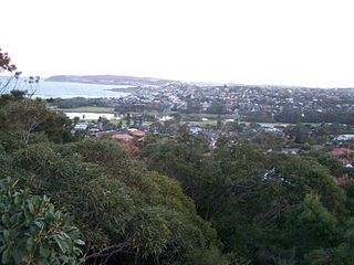
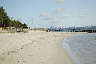
Lady Robinsons Beach is the stretch of beach between the mouth of the Cooks River and the mouth of Georges River on the western shore of Botany Bay in Sydney, New South Wales, Australia. Originally known as Seven Mile Beach, it was renamed after the wife of the then Governor, Sir Hercules Robinson. Isolated settlements separated from the beach by sand dunes were also given the name of Lady Robinson's Beach as their postal address.
Brighton-le-Sands: a brief history to 31 January 1971, prior to the name change for the suburb
Rockdale Ilinden Sports Centre was located on the grounds of Barton Park in Arncliffe, New South Wales in Australia. It was the home ground of the Rockdale Ilinden Football Club, who played in the New South Wales Super League.

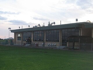
Bicentennial Park South, nicknamed Rockdale Ilinden Sports Centre, is a football (soccer) stadium in Rockdale, a suburb of Sydney in New South Wales, Australia.

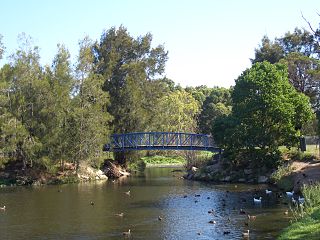
Bardwell Creek, an urban watercourse of the Cooks River catchment, is located in the southern suburbs of Sydney, in New South Wales, Australia.
 Bicentennial Park
 Bicentennial Park
 Bicentennial Park

