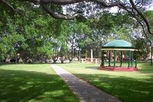
Oxford Falls Peace Park is a park in Oxford Falls, New South Wales, Australia, a suburb of Sydney.
Contents
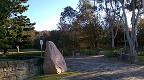
Oxford Falls Peace Park is a park in Oxford Falls, New South Wales, Australia, a suburb of Sydney.
The park is the home to Northern Beaches Council's ANZAC Day ceremonies. It is also home to many celebrations and services throughout the year. Oxford Falls Grammar School, across the road from the Peace Park, often provides bands to play commemorative music on these special days. [1]

The Oxford Falls Public School first opened in the small Church of England at Oxford Falls in 1928 with eight enrolments. The present building on the Peace Park site was built in 1930. With the school's closure in 1986, the schoolhouse was threatened with demolition but with the assistance of a local campaign and the support of Warringah Council, including the local councillor Paul Couvret, the peace park was created and the school now serves as a community hall and is the site of the annual ANZAC Day dawn service. [2]
The wall surrounding the still centre has various bits of history on it. [3]

Balgowlah is a suburb of northern Sydney, in the state of New South Wales, Australia. Balgowlah said to be an Aboriginal name for "North Harbour". The area now known as Balgowlah was known to the Aboriginals as Jilling.

The Northern Beaches is a region within Northern Sydney, in the state of New South Wales, Australia, near the Pacific coast. This area extends south to the entrance of Port Jackson, west to Middle Harbour and north to the entrance of Broken Bay. The area was formerly inhabited by the Garigal or Caregal people in a region known as Guringai country.
Dobroyd Head is a point or headland in the Northern Beaches local government area, in the suburb of Balgowlah Heights, New South Wales, Australia. It is part of the Sydney Harbour National Park, which contains examples of ecosystems at risk such as coastal heath. Tania Park is located to the immediate north-east, and contains the 2MWM 90.3 transmitter. There is a lookout sited on the headland named after Arabanoo, the first Aboriginal man to live among European settlers who was captured in Manly Cove in 1788.

Balgowlah Heights is a suburb of northern Sydney, in the state of New South Wales, Australia 11 kilometres north-east of the Sydney central business district in the local government area of Northern Beaches Council, in the Northern Beaches region. Balgowlah Heights shares the postcode 2093 with the adjacent Balgowlah and North Balgowlah.

Manly is a beach-side suburb of northern Sydney, in the state of New South Wales, Australia. It is 17 kilometres (11 mi) north-east of the Sydney central business district and is currently one of the three administrative centres of the local government area of Northern Beaches Council. Manly has a long-standing reputation as a tourist destination, owing to its attractive setting on the Pacific Ocean and easy accessibility by ferry.

Mona Vale is a suburb of Sydney, in the state of New South Wales, Australia. It is located 28 kilometres north of the Sydney central business district, in an area known as the Northern Beaches. Formerly the administrative centre of Pittwater Council, it is now located in the local government area of Northern Beaches Council. The traditional custodians of the area are the Garigal people. It is often colloquially referred to as "Mona".
Cammeray is a residential suburb located five kilometres north of the Sydney Central Business District (CBD) and is part of the North Sydney Council local government area. Cammeray is part of the Lower North Shore region of Northern Sydney.
Manly Vale is a suburb of northern Sydney, in the state of New South Wales, Australia 17 kilometres north-east of the Sydney central business district in the local government area of Northern Beaches Council, in the Northern Beaches region.

Terrey Hills is a suburb of Northern Sydney, in the state of New South Wales, Australia 25 kilometres north of the Sydney central business district in the local government area of Northern Beaches Council. It is part of the Forest District and Northern Beaches region.
Oxford Falls is a suburb of northern Sydney, in the state of New South Wales, Australia 20 kilometres north-east of the Sydney central business district in the local government area of Northern Beaches Council. Oxford Falls is part of the Northern Beaches region and also considered to be part of the Forest District, colloquially known as The Forest.
North Manly is a suburb of northern Sydney, in the state of New South Wales, Australia 17 kilometres north-east of the Sydney central business district in the local government area of Northern Beaches Council. It is part of the Northern Beaches region.
Belrose is a suburb of Sydney in the state of New South Wales, Australia 19 kilometres north-east of the Sydney central business district in the local government area of Northern Beaches Council. Belrose is also considered to be part of the Forest District, colloquially known as The Forest.
Curl Curl is a suburb of northern Sydney in the state of New South Wales, Australia, 18 kilometres (11 mi) north-east of the Sydney central business district, in the local government area of Northern Beaches Council. It is part of the Northern Beaches region.
Berala is an inner suburb of Sydney, which connects the inner west, south west and western parts of Sydney in the state of New South Wales, Australia, located only 16 kilometres west of the central business district, in the local government area of Cumberland Council. Postcode: 2141, sharing it with Lidcombe.

Brookvale is a suburb of northern Sydney, in the state of New South Wales, Australia. Brookvale is 16 kilometres north-east of the Sydney central business district, in the local government area of Northern Beaches Council. It is part of the Northern Beaches region.
Cromer is a suburb of northern Sydney, in the state of New South Wales, Australia. Cromer is 20 kilometres north-east of the Sydney central business district, in the local government area of Northern Beaches Council and is part of the Northern Beaches region. Cromer is bordered to the north-east by Narrabeen Lagoon.
The Manly Dam Reserve, also known as the Manly Warringah War Memorial Park, is an urban bushland reserve located in the Northern Beaches region of Sydney, Australia. The reserve adjoins the south-eastern edge of Garigal National Park.

Freshwater is a suburb of northern Sydney, in the state of New South Wales, Australia. Freshwater is located 17 kilometres (11 mi) north-east of the Sydney central business district, in the local government area of Northern Beaches Council and is part of the Northern Beaches region.
Paul Couvret was a Dutch–Australian military veteran, New South Wales schoolteacher and local Councillor. He was a Councillor on Warringah Council from 1973 to 1995 and was Shire President from 1979 to 1983.
Mortdale Memorial Park is a reserve located in the southern Sydney suburb of Mortdale. It contains a war memorial commemorating local people who served their country in time of war. The park is a popular place for picnics, weddings, and concerts.
33°44′23″S151°14′41″E / 33.73969541°S 151.2447077°E
| | This article related to the geography of Sydney is a stub. You can help Wikipedia by expanding it. |