
Sydney is the capital city of the state of New South Wales and the most populous city in Australia. Located on Australia's east coast, the metropolis surrounds Sydney Harbour and extends about 80 km from the Pacific Ocean in the east to the Blue Mountains in the west, and about 80 km from the Ku-ring-gai Chase National Park and the Hawkesbury River in the north and north-west, to the Royal National Park and Macarthur in the south and south-west. Greater Sydney consists of 658 suburbs, spread across 33 local government areas. Residents of the city are colloquially known as "Sydneysiders". The estimated population in June 2023 was 5,450,496, which is about 66% of the state's population. The city's nicknames include the "Emerald City" and the "Harbour City".
Redfern is an inner southern suburb of Sydney located 3 kilometres (1.9 mi) south of the Sydney central business district and is part of the local government area of the City of Sydney. Strawberry Hills is a locality on the border with Surry Hills. The area experienced the process of gentrification and is subject to extensive redevelopment plans by the state government, to increase the population and reduce the concentration of poverty in the suburb and neighbouring Waterloo.

Camperdown is an inner western suburb of Sydney, in the state of New South Wales, Australia. Camperdown is located 4 kilometres south-west of the Sydney central business district and is part of the Inner West region. Camperdown lies across the local government areas of the City of Sydney and Inner West Council.

Surry Hills is an inner-east suburb of Sydney, in the state of New South Wales, Australia. Surry Hills is immediately south-east of the Sydney central business district in the local government area of the City of Sydney. Surry Hills is surrounded by the suburbs of Darlinghurst to the north, Chippendale and Haymarket to the west, Moore Park and Paddington to the east and Redfern to the south. It is often colloquially referred to as "Surry".

Central is a heritage-listed railway station located in the centre of Sydney, New South Wales, Australia. The station is Australia's largest and second busiest railway station, and is a major transport interchange for NSW TrainLink inter-city rail services, Sydney Trains commuter rail services, Sydney Metro services, Sydney light rail services, bus services, and private coach transport services. The station is also known as Sydney Terminal. The property was added to the New South Wales State Heritage Register on 2 April 1999. It recorded 85.4 million passenger movements in 2018 and serves over 250,000 people daily.

The Inner West of Sydney is an area directly west of the Sydney central business district, New South Wales, Australia. The suburbs that make up the Inner West are predominantly located along the southern shore of Port Jackson, stretching south to the shores of the Cooks River. The western boundary of the Inner West is approximately the A3 arterial road, which divides the Inner West from the Greater Western Sydney region. The Inner West is much larger than the Inner West Council local government area. The Inner West roughly corresponds with the Parish of Petersham and Parish of Concord, two cadastral divisions used for land titles.

The Eastern Suburbs is the eastern metropolitan region of Sydney, New South Wales, Australia.

Darlington is a small, inner-city suburb of Sydney, New South Wales, Australia. Darlington is located about three kilometres south of the Sydney central business district and is part of the local government area of the City of Sydney. At the time of its incorporation in 1864, it had the distinction of being the smallest municipality in the Sydney metropolitan area, at a mere 44 acres. Darlington is bordered by City Road, Cleveland Street, Golden Grove Street, Wilson Street and Abercrombie Street.

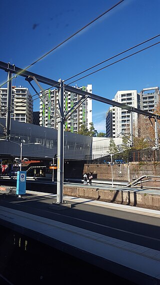
Redfern railway station is a heritage-listed former railway bridge and now railway station located on the Main Suburban railway line in the Inner City Sydney suburb of Redfern in the City of Sydney local government area of New South Wales, Australia. It was designed by John Whitton and built by Department of Railways. It is also known as Redfern Railway Station group and Tenterfield railway. The property was added to the New South Wales State Heritage Register on 2 April 1999.

Glenbrook is a township of the Lower Blue Mountains of New South Wales, Australia. It is located 63 kilometres (39 mi) west of the Sydney central business district, in the local government area of the City of Blue Mountains. As of the 2021 Australian census Glenbrook had a population of 5,078 people.

Moore Park is a suburb in the Eastern Suburbs of Sydney located 3 kilometres (1.9 mi) from the CBD, in the state of New South Wales, Australia. It is part of local government area of the City of Sydney.

Marrickville is a suburb in the Inner West of Sydney, in the state of New South Wales, Australia. Marrickville is located 7 kilometres south-west of the Sydney central business district and is the largest suburb in the Inner West Council local government area.

Sydenham is a suburb in the Inner West of Sydney, in the state of New South Wales, Australia. Sydenham is located 8 kilometres south of Sydney central business district and is part of the local government area of Inner West Council. Sydenham is surrounded by the suburbs of Marrickville, St Peters and Tempe.

Cabarita is a bayside suburb in the Inner West of Sydney, in the state of New South Wales, Australia. Cabarita is located 16 kilometres west of the Sydney central business district, in the local government area of the City of Canada Bay.

Enfield is a suburb in the Inner West of Sydney, in the state of New South Wales, Australia. It is 11 kilometres south-west of the Sydney central business district in the local government area of Municipality of Burwood.
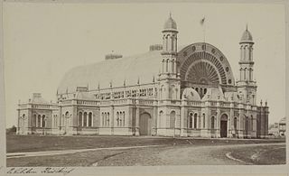
The first Sydney Intercolonial Exhibition was a series of exhibitions inspired by the historic Great Exhibition held in London in 1851. The Colony of New South Wales mounted its first such exhibition in 1854 in preparation for the Paris Exhibition of 1855, another in 1861 in preparation for the London Exhibition of 1862, and then several more until being held annually throughout the 1870s under the name Metropolitan Intercolonial Exhibition.

The Royal Agricultural Society of New South Wales was founded on 5 July 1822, when a group of Sydney's leading citizens formed the Agricultural Society of NSW, and is "a not-for-profit organisation committed to supporting agricultural development and rural communities in Australia." The society has been responsible for holding the Sydney Royal Easter Show since 1823.

The Sydney Freight Network is a network of dedicated railway lines for freight in Sydney, Australia, linking the state's rural and interstate rail network with the city's main yard at Enfield and Port Botany. Its primary components are the Southern Sydney Freight Line (SSFL) and a line from Sefton to Enfield and Port Botany. The Network has been managed by the Australian Rail Track Corporation (ARTC) since 2012. Prior to the completion of the SSFL, it was managed by RailCorp as the Metropolitan Freight Network.
The following is a timeline of the history of the city of Sydney, New South Wales, Australia.

The Eveleigh Railway Workshops machinery is a heritage-listed former railway workshops machinery located on the Main Suburban railway line in the inner western Sydney suburb of Redfern in the City of Sydney local government area of New South Wales, Australia. It is also known as Eveleigh Locomotive Workshops machinery. The property is owned by Transport for NSW, an agency of the Government of New South Wales. It was added to the New South Wales State Heritage Register on 2 April 1999.

