
The Garigal National Park is a protected national park that is located within the North Shore and Forest District regions of Sydney, New South Wales, in eastern Australia. The 2,202-hectare (5,440-acre) national park is situated approximately 20 kilometres (12 mi) north of the Sydney central business district.

Ku-ring-gai Chase National Park is a national park on the northern side of Sydney in New South Wales, Australia. The 14,977-hectare (37,010-acre) park is 25 kilometres (16 mi) north of the Sydney central business district and generally comprises the land east of the M1 Pacific Motorway, south of the Hawkesbury River, west of Pittwater and north of Mona Vale Road. It includes Barrenjoey Headland on the eastern side of Pittwater.

Palm Beach is a suburb in the Northern Beaches region of Sydney, in the state of New South Wales, Australia. Palm Beach is located 41 kilometres (25 mi) north of the Sydney central business district, in the local government area of Northern Beaches Council. Palm Beach sits on a peninsula at the end of Barrenjoey Road, between Pittwater and Broken Bay. The population of Palm Beach was 1,593 as at the 2016 census.
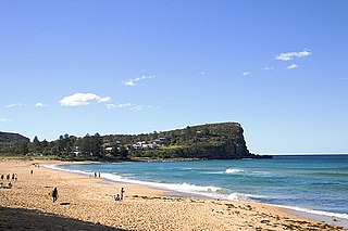
Avalon Beach is a northern beachside suburb of Sydney, in the state of New South Wales, Australia. It is 37 kilometres north of the Sydney central business district, in the local government area of Northern Beaches Council, in the Northern Beaches region. The area was previously called Avalon, with the name Avalon Beach being assigned during a change in boundaries and names in the Pittwater region in 2012.

Pittwater Council was a local government area on the Northern Beaches of Sydney, in the state of New South Wales, Australia. It covered a region adjacent to the Tasman Sea about 30 kilometres (19 mi) north of the Sydney central business district. The area is named after Pittwater, the body of water adjacent to much of the area governed. First proclaimed in 1906 as the A Riding of Warringah Shire, the area was proclaimed as the Municipality of Pittwater on 1 May 1992. On 12 May 2016, the Minister for Local Government announced that Pittwater Council would be subsumed into the newly formed Northern Beaches Council. The last mayor of Pittwater Council was Councillor Jacqui Townsend, an independent politician.

Narrabeen is a beachside suburb in northern Sydney, in the state of New South Wales, Australia. Narrabeen is 23 kilometres north-east of the Sydney central business district, in the local government area of Northern Beaches Council and is part of the Northern Beaches region. This area was named Broken Bay by James Cook as he sailed by.

Dee Why is a coastal suburb of northern Sydney, in the state of New South Wales, Australia, 18 kilometres north-east of the Sydney central business district. It is the administrative centre of the local government area of Northern Beaches Council and, along with Brookvale, is considered to be the main centre of the Northern Beaches region.

Pittwater is a semi-mature tide dominated drowned valley estuary, located about 40 kilometres (25 mi) north of the Sydney central business district, New South Wales, Australia; being one of the bodies of water that separate greater Metropolitan Sydney from the Central Coast.
The Manly Dam Reserve, also known as the Manly Warringah War Memorial Park, is an urban bushland reserve located in the Northern Beaches region of Sydney, Australia. The reserve adjoins the south-eastern edge of Garigal National Park.

The Sydney Turpentine-Ironbark Forest (STIF) is wet sclerophyll forest community of Sydney, New South Wales, Australia, that is typically found in the Inner West and Northern region of Sydney. It is also among the three of these plant communities which have been classified as Endangered, under the New South Wales government's Threatened Species Conservation Act 1995, with only around 0.5% of its original pre-settlement range remaining.

The Boronia Park, or the Boronia Park Reserve, is a waterfront parkland and nature reserve wholly within the suburb of Hunters Hill, in the Municipality of Hunter's Hill, New South Wales, Australia. The park dates back to pre-colonial New South Wales, with original and widely diverse flora and fauna:
...Boronia Park is the best place to gain an idea of Hunter's Hill's pre-European landscape, as it has the largest intact stretch of bushland. Its sandstone slopes carry characteristic open-forest of Eucalyptus piperita, Eucalyptus gummifera and Angophora costata, with a great variety of understorey shrubs and small trees. Towards the top of the slope is an area of Kunzea ambigua shrubland, while Blackbutt, Eucalyptus pilularia grow on the more sheltered aspects, and a small creek tumbles down a steep waterfall to form a pool beside Grey Mangroves along the river's edge...the Turpentine-Ironbark forest's only remnant in Hunters Hill today is a small stand of Syncarpia glomulifera, with some understorey shrubs, near the entrance to Boronia Park...

The Wolli Creek Regional Park is a 50 hectares regional park, located adjacent to Wolli Creek within the Wolli Creek Valley, between Bexley North and Tempe in south-west Sydney, New South Wales, Australia.

The Central Gardens Nature Reserve, also called Central Gardens, is a protected nature reserve located in the western suburbs of Sydney, New South Wales, Australia. Established in 1976, the 12-hectare (30-acre) reserve, garden and fauna and wildlife park is situated in the suburb of Merrylands and is managed by Cumberland Council. The park is regionally important and it attracts visitors outside the Cumberland local government area. The bushland contains remnants of Cumberland Plain Woodland and is approximately 3.5 hectares.

The Northern Beaches Council is a local government area located in the Northern Beaches region of Sydney, in the state of New South Wales, Australia. The council was formed on 12 May 2016 after the amalgamation of Manly, Pittwater and Warringah Councils.
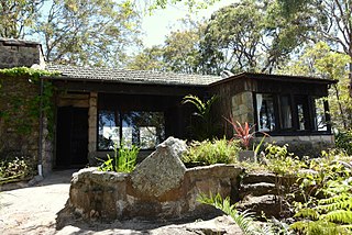
Hy Brasil, also sometimes Hy-Brasil, is a heritage-listed former weekend retreat and now house located at 62 Chisholm Road, Avalon Beach, Northern Beaches Council, New South Wales, Australia. It was designed by Alexander Stewart Jolly and built in 1936. It is also known as The Gem and Hi Brasil. It was added to the New South Wales State Heritage Register on 2 April 1999.

Prospect Nature Reserve is a nature reserve and recreational area that is situated in the western suburbs of Sydney, New South Wales, Australia, which incorporates the Prospect Reservoir, and also features picnic spots, lookouts, walking tracks and BBQ areas within the Australian bush. It is located within the Blacktown City local government area, but is also close to the boundaries of Cumberland Council and the City of Fairfield.

The ecology of Sydney, located in the state of New South Wales, Australia, is diverse for its size, where it would mainly feature biomes such as grassy woodlands or savannas and some sclerophyll forests, with some pockets of mallee shrublands, riparian forests, heathlands, and wetlands, in addition to small temperate rainforest fragments.
Tambourine Bay is a bay located in between the suburbs of Riverview and Longueville in the Lower North Shore of Sydney, NSW, Australia. The bay and its adjoining creek is a northern tributary of the Lane Cove River, a ria that joins Sydney harbour to Greenwich and Woolwich. The bay's foreshore and surrounding park areas are managed by the municipality of Lane Cove.
Waratah Park is a heritage-listed former Aboriginal land and fauna sanctuary and now Aboriginal title claim at 13 Namba Road, Duffys Forest in the Northern Beaches Council local government area of New South Wales, Australia. It is also known for serving as the fictional Waratah National Park, the filming location for the Australian television series Skippy the Bush Kangaroo, when the area was still undeveloped Crown land. After the series ended, the Crown land remained mostly undeveloped, with the government granting management of the area to a series of operators until August 2014, when the government passed full ownership of the land to the Metropolitan Local Aboriginal Land Council. It was added to the New South Wales State Heritage Register on 27 February 2015.

