Footscray is an inner-city suburb in Melbourne, Victoria, Australia, 5 km (3.1 mi) west of Melbourne's Central Business District, located within the City of Maribyrnong local government area and its council seat. Footscray recorded a population of 17,131 at the 2021 census.

Carnegie is a suburb in Melbourne, Victoria, Australia, 12 km south-east of Melbourne's central business district, on the railway line between Caulfield and Oakleigh, located within the City of Glen Eira local government area. Carnegie recorded a population of 17,909 at the 2021 census.

Leichhardt is a suburb in the Inner West of Sydney, in the state of New South Wales, Australia. Leichhardt is located 5 kilometres west of the Sydney central business district (CBD) and is the administrative centre for the local government area (LGA) of the Inner West Council. The suburb is bordered by Haberfield to the west, Annandale to the east, Lilyfield to the north and Petersham, Lewisham and Stanmore to the south.

Epping is a suburb of Sydney, in the Australian state of New South Wales, 18 kilometres north-west of the Sydney central business district in the local government area of the City of Parramatta. Epping is in the Northern Sydney region. The suburb is the most north-eastern area of the City of Parramatta. North Epping is a separate suburb to the north and under a different council, Hornsby Shire.

Ashfield is a suburb in the Inner West of Sydney, in the state of New South Wales, Australia. Ashfield is about 8 kilometres west of the Sydney central business district.

Moore Park is a suburb in the Eastern Suburbs of Sydney located 3 kilometres (1.9 mi) from the CBD, in the state of New South Wales, Australia. It is part of local government area of the City of Sydney.

Marrickville is a suburb in the Inner West of Sydney, in the state of New South Wales, Australia. Marrickville is located 7 kilometres south-west of the Sydney central business district and is the largest suburb in the Inner West Council local government area.

Yarraville is an inner-city suburb in Melbourne, Victoria, Australia, 6 km (3.7 mi) west of Melbourne's Central Business District, located within the City of Maribyrnong local government area. Yarraville recorded a population of 15,636 at the 2021 census.
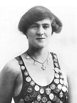
Sarah Frances "Fanny" Durack, also known by her married name Fanny Gately, was an Australian competition swimmer. From 1910 until 1918 she was the world's greatest female swimmer across all distances from freestyle sprints to the mile marathon.

Enfield is a suburb in the Inner West of Sydney, in the state of New South Wales, Australia. It is 11 kilometres south-west of the Sydney central business district in the local government area of Municipality of Burwood.

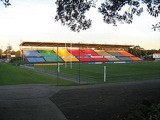
Leichhardt Oval is a rugby league and soccer stadium in Lilyfield, New South Wales, Australia. It is currently one of three home grounds for the Wests Tigers National Rugby League (NRL) team, along with Campbelltown Stadium and Western Sydney Stadium. Prior to its merger with the Western Suburbs Magpies, it was the longtime home of the Balmain Tigers, who used the ground from 1934–1994 and 1997–1999. It was named after Ludwig Leichhardt.

Yeronga Memorial Park is a heritage-listed park at Ipswich Road, Yeronga, City of Brisbane, Queensland, Australia. The park has an area of 224,600 square metres (2,418,000 sq ft) and is one of the oldest in Brisbane, having been established in 1882, and has been a World War I memorial since 1917. It was added to the Queensland Heritage Register on 2 December 2005.
Concord Oval, is a rugby football stadium in the inner-west Sydney suburb of Concord, Australia. The stadium is able to hold 5,000 people as of November 2022, down from 20,000 when the Concord Oval was opened in 1985. As of 2022, it is used mostly for rugby union matches and hosted eight matches during the 1987 Rugby World Cup. It is also a venue for soccer matches and local rugby league matches.

The Australian Water Polo League is the premier Australian domestic water polo competition. The men's league was established in 1990 with the women's league following in 2004. The league is administered by Water Polo Australia, and is contested by eleven clubs, each fielding a women's and a men's team. As of 2024 five clubs are based in Sydney and one each in Melbourne, Adelaide, Brisbane, Fremantle, Newcastle and Perth.

Glenelg East is a residential suburb 9 kilometres (5.6 mi) south-west of the centre of Adelaide, South Australia. It is characterised by quarter-acre blocks with heritage homes and parks intermingled with contemporary modern homes and low-rise multi-dwelling units.
Kardinia Park is a major public park located in South Geelong, Victoria. A number of public and sporting facilities are located in the park: a major AFL stadium, a secondary football oval, a cricket field, an open air swimming pool, a number of netball courts, various sporting clubrooms, and a senior citizens centre. The park is bounded by Moorabool Street, the Geelong railway line, Kilgour Street, Latrobe Terrace, and Park Crescent.
While not being urged to avoid competition, women had few opportunities to compete in sport in Australia until the 1880s. After that date, new sporting facilities were being built around the country and many new sport clubs were created. For swimming, the rapid expansion of facilities took place during the 1880s and the 1890s. Compared to the past when the whole of the swimming community was made up of males, currently 55 percent of the Australian swimming membership is made up of women. Not only do females dominate swimming in the pool but there are more than 5,500 female coaches in the swimming world in Australian and over 2,000 female technical officials.
Ocean pools are an important feature of the Australian coastline particularly in New South Wales. Ocean pools or ocean baths are defined as public seawater pools sited on a rocky surf coast, so that waves can wash into the pool. The width, length and depth of ocean pools varies and often depends on their location on the coastline. Australia also has many harbour pools and these are usually netted or fenced and located in harbours or river mouths but not regarded as ocean pools.

Inner West Council is a local government area located in the Inner West region of Sydney in the state of New South Wales, Australia. The council makes up the eastern part of this wider region, and was formed on 12 May 2016 from the merger of the former Ashfield, Leichhardt and Marrickville councils.
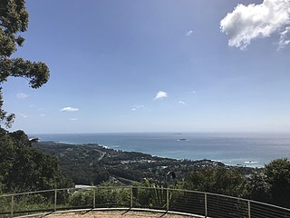
Korora is a suburb of the City of Coffs Harbour in New South Wales, Australia, located 6 km north of the city centre. Korora is located in a basin that runs from the foothills of the Great Dividing Range in the west to Korora Bay in the east. It is bisected by the Pacific Highway, which runs south to north between Sydney and Brisbane. The section of Korora between the Pacific Highway and the coast is mainly residential, with some tourist facilities. The section west of the Highway consists of larger residential blocks and farms growing mainly bananas and blueberries. The west-most section of Korora is forested and includes part of the Ulidarra National Park. The Korora basin is drained by creeks that flow into Pine Brush Creek and enter the sea at Hills Beach.