Grey Box Reserve

Last updated

Grey Box Reserve
Grey Box Reserve.jpg
Boothtown Reserve, just south of the contiguous Grey Box Reserve
Grey Box Reserve
Type Nature reserve
Location Greystanes, New South Wales, Australia
Coordinates 33°49′33″S150°55′53″E / 33.825713°S 150.9313571°E / -33.825713; 150.9313571
Area6.5 hectares (16 acres)
Operated by Cumberland City Council
StatusClosed for public

The Grey Box Reserve, or Greystanes Grey Box Reserve, is a small nature reserve situated in the suburb of Greystanes, New South Wales in Western Sydney, Australia. [1] A remnant bushland of the Cumberland Plain Woodland, it mainly features native vegetation. [2] The reserve is so-named because of its abundance of Eucalyptus moluccana , reflecting the pre-European cultural landscape of the area. [3] [4]

Contents

Geography

The reserve is bounded by Silverthorne Road to the west in Pemulwuy and Greystanes Road to the east. The form of the Reserve is typical of the soft undulating hills of the Cumberland Plain, and is located largely on a gentle west-facing slope inside a small water catchment that transiently drains southwards to Prospect. It is a reasonably disturbed bushland with regions of low, moderate and high resiliency, and areas of moderate to high weed invasion with the soil being clay that is derived from Wianamatta Shale Group. The reserve is primarily composed of Shale Hills Woodland, an ecological constituent of the Cumberland Plain Woodland. [1] [5]

The Reserve is connected to five main environment corridors of remnant vegetation and fauna habitats within the vicinity, such as the Lower Prospect Canal Reserve Cycleway, which features disjunct patches of CPW and Alluvial Woodland, Prospect Creek and the Alluvial Woodland within the Long Street Park, the Prospect Reservoir woodland to the west and Greystanes Creek, which ties the Reserve to the major habitat corridors within the City of Parramatta including Toongabbie Creek, Quarry Branch Creek and Lake Parramatta. [6]

Biota

Native species include Pimelea spicata and eucalyptus sp., though ground cover is covered by a mixture of exotic and native grasses. The main weeds found in the reserve are, Olea europaea subsp. cuspidata and Lantana camara in the mid storey, in addition to grass and annual weeds in the ground cover, such as Eragrostis curvula. [1]

Native animals include three frog species such as Litoria aurea, five reptile species, sixteen mammal species, over fifty bird species, and as well as six exotic mammal species. Bats found in the reserve include Tadarida australis, Petaurus norfolcensis, Falsistrellus tasmaniensis, Scoteanax rueppellii, Pteropus poliocephalus, Mormopterus norfolkensis, Mormopterus sp., Chalinolobus gouldii and Scotorepens orion. Owls featured are Tyto novaehollandiae and Ninox strenua. Meridolum corneovirens is also present. [7]

In 2003, hollow bearing logs and artificial bat boxes were installed in some of the trees to supply extra perching sites for microchiropteran bats and other cavernous-dependent fauna. [8]

Access

The reserve is closed to public access, therefore there are no walking tracks in the area nor any recreational access; a 1.8 meter tall chain-wire fence exists along the southern and eastern boundary of the reserve on Greystanes Road, in addition to a three-strand wire perimeter fence on some of the other boundaries of the reserve. Though a walking track from Silverthorne Road does edge through the northwestern boundary of the reserve. 
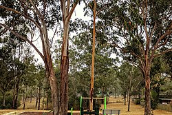
Boothtown Reserve, an abutting park that features a children's playground, is situated on the southern perimeter of the reserve and would feature homogenous vegetation. [1] The reserve features tracks for firefighters, provided that a bushfire should start in the reserve or hazard reduction burns. [9]

See also

Related Research Articles

<span class="mw-page-title-main">Greystanes, New South Wales</span> Suburb of Greater Western Sydney, New South Wales, Australia

Greystanes is a suburb in Greater Western Sydney, New South Wales, Australia. Greystanes is located 25 kilometres west of the Sydney central business district in the local government area of Cumberland Council. Founded in the late 1790s, Greystanes is one of the oldest suburbs in Sydney.

<span class="mw-page-title-main">Pemulwuy, New South Wales</span>

Pemulwuy is a suburb in Greater Western Sydney, in the state of New South Wales, Australia. Pemulwuy is located 30 kilometres west of the Sydney central business district in the local government area of the Cumberland Council. Pemulwuy is home to the highest point between the Blue Mountains and Sydney, the summit of Prospect Hill.

<span class="mw-page-title-main">Geography of Sydney</span> Overview of the geography of Sydney

The geography of Sydney is characterised by its coastal location on a basin bordered by the Pacific Ocean to the east, the Blue Mountains to the west, the Hawkesbury River to the north and the Woronora Plateau to the south. Sydney lies on a submergent coastline on the east coast of New South Wales, where the ocean level has risen to flood deep river valleys (rias) carved in the Sydney sandstone. Port Jackson, better known as Sydney Harbour, is one such ria.

<span class="mw-page-title-main">Cumberland Plain</span> Plain in Australia

The Cumberland Plain, an IBRA biogeographic region, is a relatively flat region lying to the west of Sydney CBD in New South Wales, Australia. Cumberland Basin is the preferred physiographic and geological term for the low-lying plain of the Permian-Triassic Sydney Basin found between Sydney and the Blue Mountains, and it is a structural sub-basin of the Sydney Basin.

<span class="mw-page-title-main">Lower Prospect Canal Reserve</span>

The Lower Prospect Canal Reserve is a heritage-listed former farm and public water supply canal and now bushy corridor and nature reserve stretching 7.7 kilometres (4.8 mi) through the heart of suburban Sydney, New South Wales, Australia. The lineal corridor stretches from Prospect Reservoir to Sydney Water Pipehead at Albert Street, Guildford with the majority of the reserve located in Greystanes, which is a suburb within the Cumberland Council area.

<span class="mw-page-title-main">Sydney Turpentine-Ironbark Forest</span>

The Sydney Turpentine-Ironbark Forest (STIF) is wet sclerophyll forest community of Sydney, New South Wales, Australia, that is typically found in the Inner West and Northern region of Sydney. It is also among the three of these plant communities which have been classified as Endangered, under the New South Wales government's Threatened Species Conservation Act 1995, with only around 0.5% of its original pre-settlement range remaining.

<span class="mw-page-title-main">Duck River (New South Wales)</span> River in New South Wales, Australia

The Duck River is a perennial stream and southern tributary of the Parramatta River, in Sydney, New South Wales, Australia.

<span class="mw-page-title-main">Prospect Hill (New South Wales)</span>

Prospect Hill is a heritage-listed hill in Pemulwuy and Prospect in the greater western region of Sydney, New South Wales, Australia. Situated about 30 kilometres west of central Sydney, the hill is Sydney's largest body of igneous rock and is higher than the ridges of the Cumberland Plain around it, with its present-day highest point being 117 metres high, although before its summit was quarried away it rose to a height of 131 metres above sea level.

<span class="mw-page-title-main">Wolli Creek Regional Park</span>

The Wolli Creek Regional Park is a 50 hectares regional park, located adjacent to Wolli Creek within the Wolli Creek Valley, between Bexley North and Tempe in south-west Sydney, New South Wales, Australia.

<span class="mw-page-title-main">Western Sydney Parklands</span>

The Western Sydney Parklands is an urban park system and a nature reserve located in Sydney, New South Wales, Australia. The NSW government has spent around $400 million for the park. The park is governed by the NSW National Parks and Wildlife Service and is listed under the National Parks and Wildlife Act 1974. The Parklands begin in the north in the City of Blacktown, cross the City of Fairfield, and end in the City of Liverpool.

<span class="mw-page-title-main">Western Sydney Regional Park</span> Park in Sydney

Western Sydney Regional Park is a large urban park and a nature reserve situated in Western Sydney, Australia within the suburbs of Horsley Park and Abbotsbury. A precinct of Western Sydney Parklands, a park system, and situated within the heart of the Cumberland Plain Woodland, the regional park features several picnic areas, recreational facilities, equestrian trails, and walking paths within the Australian bush.

<span class="mw-page-title-main">Central Gardens Nature Reserve</span>

The Central Gardens Nature Reserve, also called Central Gardens, is a protected nature reserve located in the western suburbs of Sydney, New South Wales, Australia. Established in 1976, the 12-hectare (30-acre) reserve, garden and fauna and wildlife park is situated in the suburb of Merrylands and is managed by Cumberland Council. The park is regionally important and it attracts visitors outside the Cumberland local government area. The bushland contains remnants of Cumberland Plain Woodland and is approximately 3.5 hectares.

<i>Setirostris</i> Genus of bats

Setirostris eleryi is a species of small insectivorous bat found in inland eastern Australia. It is the sole species of the molossid genus Setirostris, a name that refers to the coarse bristles on their faces. Earlier common names have referred to this unique feature, and the 'free-tail' that is a common feature of its microchiropteran family, the Molossidae; no single common name emerged during the taxonomic revisions that identified what was referred to as the bristle-faced freetail.

<span class="mw-page-title-main">Cooks River/Castlereagh Ironbark Forest</span>

The Cooks River/Castlereagh Ironbark Forest (CRCIF) is a scattered, dry sclerophyll, open-forest to low woodland and scrubland which occurs predominantly in the Cumberland subregion of the Sydney basin bioregion, between Castlereagh and Holsworthy, as well as around the headwaters of the Cooks River. The Cooks River Clay Plain Scrub Forest is a component of this ecological community, though both belong to a larger occurring community called the Temperate Eucalyptus fibrosa/Melaleuca decora woodland.

<span class="mw-page-title-main">Wetherill Park Nature Reserve</span>

Wetherill Park Nature Reserve, also called Wetherill Park Reserve, is an urban park and a nature reserve situated in the western suburbs of Sydney, New South Wales, Australia. The reserve contains an open woodland and bushland which feature native plants, such as eucalyptus trees, and recreational areas.

<span class="mw-page-title-main">Rosford Street Reserve</span>

Rosford Street Reserve, or Rosford Reserve, is an urban park and nature reserve situated in the western suburbs of Sydney, New South Wales, Australia. The reserve contains an open grassland, woodlands and recreational areas surrounded by native plants, such as eucalyptus trees. Janice Crosio Oval is a fenced sports ground incorporated within the reserve. The park is one of the largest in the Fairfield LGA area.

<span class="mw-page-title-main">Cumberland Plain Woodland</span> Indigenous woodland community in Sydney, Australia

The Cumberland Plain Woodland, also known as Cumberland Plain Bushland and Western Sydney woodland, is a grassy woodland community found predominantly in Western Sydney, New South Wales, Australia, that comprises an open tree canopy, a groundcover with grasses and herbs, usually with layers of shrubs and/or small trees.

<span class="mw-page-title-main">Fairfield Park Precinct</span>

Fairfield Park Precinct, or Fairfield Park, is an urban park situated in the western suburbs of Sydney, New South Wales, Australia. Situated to the south of Fairfield CBD, the park contains an open grassland, bushland, picnic spots, playgrounds, indoor and outdoor sport facilities, and recreational areas within the vicinity of native plants, such as eucalyptus trees.

<span class="mw-page-title-main">Prospect Nature Reserve</span>

Prospect Nature Reserve is a nature reserve and recreational area that is situated in the western suburbs of Sydney, New South Wales, Australia, which incorporates the Prospect Reservoir, and also features picnic spots, lookouts, walking tracks and BBQ areas within the Australian bush. It is located within the Blacktown City local government area, but is also close to the boundaries of Cumberland Council and the City of Fairfield.

<span class="mw-page-title-main">Ecology of Sydney</span> Geographic aspect of Sydney, Australia

The ecology of Sydney, located in the state of New South Wales, Australia, is diverse for its size, where it would mainly feature biomes such as grassy woodlands or savannas and some sclerophyll forests, with some pockets of mallee shrublands, riparian forests, heathlands, and wetlands, in addition to small temperate rainforest fragments.

References

  1. 1 2 3 4 Grey Box Reserve - Plan of Management Delfin Lend Lease. October 2006. Retrieved 22 October 2022.
  2. SPECIAL PRECINCT AND SITE SPECIFIC DEVELOPMENT CONTROLS Cumberland DCP – Part F1 –Residential Site Specific Development Controls
  3. National Parks and Wildlife Service (1994) Native Vegetation of the Cumberland Plain Hurstville, Australia.
  4. PemulwuyResidential Controls Holroyd Development Control Plan 2013. Page 651. Retrieved 22 October 2022.
  5. Buchanan R. (1989). Bush Regeneration: Recovering Australian Landscapes. Open Training and Education Network, TAFE NSW, Strathfield.
  6. Cumberland Ecology (2004) Nelson’s Ridge Southern Residential Lands Flora and Fauna Assessment prepared for Delfin Lend Lease
  7. National Parks and Wildlife Service (1997) Urban Bushland Biodiversity Survey State 1 Western Sydney Native Flora of Western Sydney Hurstville, Australia.
  8. Hoye, G. (2004) Results of inspection of bat boxes and echolocation call survey for Delfin Greystanes letter report, Fly By Night Bat Surveys Pty Ltd.
  9. BUSH FIRE PRONE LAND MAPS NSW Rural Fire Service. Retrieved 22 October 2022.