Cecil Hoskins Nature Reserve

Last updated

Cecil Hoskins Nature Reserve
New South Wales
IUCN category IV (habitat/species management area)
Cecil Hoskins Nature Reserve water.JPG
A swamp and wetlands are located within the reserve
Australia New South Wales relief location map.png
Red pog.svg
Cecil Hoskins Nature Reserve
Nearest town or city Bowral
Coordinates 34°31.942′S150°23.887′E / 34.532367°S 150.398117°E / -34.532367; 150.398117 Coordinates: 34°31.942′S150°23.887′E / 34.532367°S 150.398117°E / -34.532367; 150.398117
Established7 March 1975 (1975-03-07) [1]
Area0.46 km2 (0.2 sq mi) [1]
Managing authorities NSW National Parks and Wildlife Service
Website Cecil Hoskins Nature Reserve
See also Protected areas of
New South Wales

The Cecil Hoskins Nature Reserve is a protected nature reserve located in the Southern Highlands area of New South Wales Australia. The 46-hectare (110-acre) reserve is situated between the towns of Bowral and Moss Vale and is known for bird watching. [1]

State park protected area managed at the federated state level

State parks are parks or other protected areas managed at the sub-national level within those nations which use "state" as a political subdivision. State parks are typically established by a state to preserve a location on account of its natural beauty, historic interest, or recreational potential. There are state parks under the administration of the government of each U.S. state, some of the Mexican states, and in Brazil. The term is also used in the Australian state of Victoria. The equivalent term used in Canada, Argentina, South Africa and Belgium, is provincial park. Similar systems of local government maintained parks exist in other countries, but the terminology varies.

Nature reserve Protected area for flora, fauna or features of geological interest

A nature reserve is a protected area of importance for flora, fauna or features of geological or other special interest, which is reserved and managed for conservation and to provide special opportunities for study or research. Nature reserves may be designated by government institutions in some countries, or by private landowners, such as charities and research institutions, regardless of nationality. Nature reserves fall into different IUCN categories depending on the level of protection afforded by local laws. Normally it is more strictly protected than a nature park.

Southern Highlands (New South Wales) Region in New South Wales, Australia

The Southern Highlands, also locally referred to as the Highlands, is a geographical region and district in New South Wales, Australia and is 110 km south-west of Sydney. The entire region is under the local government area of the Wingecarribee Shire. The region is also considered a wine region.

Contents

Description

The nature reserve is a mostly cleared area with a dammed section of the Wingecarribee River. Much of the area was cleared in the 1820s by Charles Throsby. The Throsby Park Historic Site is located near the reserve. There is some remnant bushland with the rare Camden woollybutt and some of the best stands of snow gums in the southern Highlands. Recent plantings have increased the area of natural bushland.

Dam A barrier that stops or restricts the flow of surface or underground streams

A dam is a barrier that stops or restricts the flow of water or underground streams. Reservoirs created by dams not only suppress floods but also provide water for activities such as irrigation, human consumption, industrial use, aquaculture, and navigability. Hydropower is often used in conjunction with dams to generate electricity. A dam can also be used to collect water or for storage of water which can be evenly distributed between locations. Dams generally serve the primary purpose of retaining water, while other structures such as floodgates or levees are used to manage or prevent water flow into specific land regions. The earliest known dam is the Jawa Dam in Jordan, dating to 3,000 BC.

Wingecarribee River river in New South Wales, Australia

The Wingecarribee River, a perennial river that is part of the Hawkesbury–Nepean catchment, is located in the Southern Highlands region of New South Wales, Australia.

Charles Throsby was an Australian explorer, pioneer and parliamentarian. He opened up much new land beyond the Blue Mountains for colonial settlement. He was a grazier, and became a prominent member of New South Wales society.

Barbecue, picnic facilities and public toilets are present. The area is more of a cultural reserve than preserved natural bushland. [2]

Etymology

Sir Cecil Hoskins had been a resident at Exeter and Moss Vale and had a keen interest in gardens. He had a profound knowledge of trees and shrubs in particular and his advice on parks and gardens was sought by many. As well as his extensive home gardens at Invergowrie Exeter and later at Cardrona Moss Vale, there is much evidence of his keen interest in creating parks and gardens. For example, he planned the unique garden setting for the Portland Cement Works at Berrima, he was responsible for the planning and development of Seymour Park in Moss Vale and was Chairman of the Berrima District Committee of the Remembrance Driveway. [2]

Exeter, New South Wales Town in New South Wales, Australia

Exeter is a village in the Southern Highlands district of New South Wales, Australia, in Wingecarribee Shire. It has a station on the Main Southern railway line south of Sydney. At the 2016 census, Exeter had a population of 949.

Moss Vale, New South Wales Town in New South Wales, Australia

Moss Vale is a town in the Southern Highlands of New South Wales, Australia, in the Wingecarribee Shire. At the 2016 census, it has a population of 8,579 and is sited on the Illawarra Highway, which connects to Wollongong and the Illawarra coast via Macquarie Pass.

Berrima, New South Wales Town in New South Wales, Australia

Berrima is a historic village in the Southern Highlands of New South Wales, Australia, in Wingecarribee Shire. The village, once a major town, is located on the Old Hume Highway between Canberra and Sydney. It was previously known officially as the Town of Berrima. It is close to the three major towns of the Southern Highlands; Mittagong, Bowral and Moss Vale.

Fauna

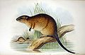
Foxes cause considerable damage to the local wildlife. They have been targeted by shooting, poisoning and trapping. The platypus, water rat and eastern grey kangaroo are recorded here.

Platypus A semi-aquatic egg-laying mammal from eastern Australia

The platypus, sometimes referred to as the duck-billed platypus, is a semiaquatic egg-laying mammal endemic to eastern Australia, including Tasmania. The platypus is the sole living representative of its family (Ornithorhynchidae) and genus (Ornithorhynchus), though a number of related species appear in the fossil record.

Eastern grey kangaroo species of mammal

The eastern grey kangaroo is a marsupial found in southern and eastern Australia, with a population of several million. It is also known as the great grey kangaroo and the forester kangaroo. Although a big eastern grey male typically masses around 66 kg and stands almost 2 m (6.6 ft.) tall, the scientific name, Macropus giganteus, is misleading: the red kangaroo of the semi-arid inland is larger, weighing up to 90 kg.

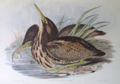
The bird life of the area is of interest. At least 90 species of birds have been recorded. Cecil Hoskins Nature Reserve is an important resting and feeding place for many migratory species, particularly waterbirds. During drought, many inland birds find refuge here. Noteworthy sightings recorded here include the blue-billed duck and the rare Australasian bittern. [2]

Drought in Australia

Drought in Australia is defined by the Australian Bureau of Meteorology as rainfall over a three-month period being in the lowest decile of what has been recorded for that region in the past. This definition takes into account that drought is a relative term and rainfall deficiencies need to be compared to typical rainfall patterns including seasonal variations. Specifically, drought in Australia is defined in relation to a rainfall deficiency of pastoral leases and is determined by decile analysis applied to a certain area. Note that this definition uses rainfall only because long-term records are widely available across most of Australia. However, it does not take into account other variables that might be important for establishing surface water balance, such as evaporation and condensation.

Blue-billed duck species of bird

The blue-billed duck is a small Australian stiff-tailed duck, with both the male and female growing to a length of 40 cm (16 in). The male has a slate-blue bill which changes to bright-blue during the breeding season, hence the duck’s common name. The male has deep chestnut plumage during breeding season, reverting to a dark grey. The female retains black plumage with brown tips all year round. The duck is endemic to Australia's temperate regions, inhabiting natural inland wetlands and also artificial wetlands, such as sewage ponds, in large numbers. It can be difficult to observe due to its cryptic nature during its breeding season through autumn and winter. The male duck exhibits a complex mating ritual. The blue-billed duck is omnivorous, with a preference for small aquatic invertebrates. BirdLife International has classified this species as Near Threatened. Major threats include drainage of deep permanent wetlands, or their degradation as a result of introduced fish, peripheral cattle grazing, salinization, and lowering of ground water.

Australasian bittern species of bird

The Australasian bittern, also known as the brown bittern or matuku hūrepo, is a large bird in the heron family Ardeidae. A secretive bird with a distinctive booming call, it is more often heard than seen. Australasian bitterns are endangered in both Australia and New Zealand.

See also

Related Research Articles

Garigal National Park Protected area in New South Wales, Australia

The Garigal National Park is a protected national park that is located within the North Shore and Forest District regions of Sydney, New South Wales, in eastern Australia. The 2,202-hectare (5,440-acre) national park is situated approximately 20 kilometres (12 mi) north of the Sydney central business district.

Leighton Moss RSPB reserve nature reserve in Lancashire, England

Leighton Moss RSPB reserve is a nature reserve in Lancashire, England, which has been in the care of the Royal Society for the Protection of Birds since 1964. It is situated at Silverdale near Carnforth, on the edge of Morecambe Bay and in the Arnside and Silverdale Area of Outstanding Natural Beauty.

Macquarie Marshes Nature Reserve Protected area in New South Wales, Australia

The Macquarie Marshes Nature Reserve is a protected natural wetland reserve that is located within the Macquarie Marshes, in the region along the lower Macquarie River in northwestern New South Wales, Australia. The 19,824-hectare (48,990-acre) reserve is situated approximately 600 kilometres (370 mi) northwest of Sydney and 100 kilometres (62 mi) north of Warren.

Division of Throsby Australian federal electoral division

The Division of Throsby was an Australian electoral division in the state of New South Wales. The division was named after Charles Throsby, a prominent pioneer and explorer in the early nineteenth century of the areas to the south of Sydney.

Devilbend Natural Features Reserve reservoir in Australia

Devilbend Natural Features Reserve is a 1,005 ha park on the Mornington Peninsula 55 km (34 mi) south-east of Melbourne, Australia, between Hastings and Mount Martha in the traditional country of the Bunurong people. It contains two decommissioned water-supply reservoirs, Devilbend and Bittern, which were the original reason the land now in the park was not developed and was protected from general public access.

Mittagong railway station

Mittagong railway station is a heritage-listed railway station on the Main South line in New South Wales, Australia. It serves the town of Mittagong in the Southern Highlands. It was added to the New South Wales State Heritage Register on 2 April 1999.

Wingecarribee Shire Local government area in New South Wales, Australia

Wingecarribee Shire is the local government area of the Southern Highlands in the state of New South Wales, Australia. The Wingecarribee Shire is around 110 kilometres (70 mi) southwest of the Sydney central business district and is part of regional Capital Country and to some extent can be considered part of the Southern Tablelands.

Manly Dam Reserve Protected area in New South Wales, Australia

The Manly Dam Reserve, also known as the Manly Warringah War Memorial Park, is a nature reserve of protected urban bushland located in the Northern Beaches region of Sydney, Australia. Located among the suburbs of Allambie Heights, North Balgowlah, Frenchs Forest and Manly Vale in the Northern Beaches Council local government area. The reserve adjoins the south-eastern edge of Garigal National Park.

Electoral district of Goulburn state electoral district of New South Wales, Australia

Goulburn is an electoral district of the Legislative Assembly in the Australian state of New South Wales. It is represented by Wendy Tuckerman of the Liberal Party.

Burrawang, New South Wales Town in New South Wales, Australia

Burrawang is a village in the Southern Highlands of New South Wales, Australia in Wingecarribee Shire. According to the 2016 Australian census, Burrawang's population was 361.

Fitzroy Falls, New South Wales New South Wales, Australia

Fitzroy Falls is a village in the Wingecarribee Shire, located within the Southern Highlands region of New South Wales, Australia. The locality was known as Yarrunga, but was renamed after the 81-metre (266 ft) waterfall. At the 2016 census, Fitzroy Falls had a population of 216.

Bowral is a town in the Southern Highlands of New South Wales, Australia. It has a history spanning nearly 200 years.

Narran Wetlands Protected area in New South Wales, Australia

The Narran Wetlands, also known as the Narran Lakes, contained within the Narran Lakes Nature Reserve, comprise a series of protected ephemeral lakes and swamps fed by the Narran River in the north-west of New South Wales, Australia. The 26,480-hectare (65,400-acre) reserve is located approximately 50 kilometres (31 mi) east of Brewarrina.

Central Gardens Nature Reserve Protected area in New South Wales, Australia

The Central Gardens Nature Reserve, also called Central Gardens, is a protected nature reserve located in the western suburbs of Sydney, New South Wales, Australia. Established in 1976, the 12-hectare (30-acre) reserve, garden and fauna and wildlife park is situated in the suburb of Merrylands and is managed by Cumberland Council. The park is regionally important and it attracts visitors outside the Cumberland LGA area. The bushland contains remnants of Cumberland Plain Woodland and is approximately 3.5 hectares in area.

Throsby Park Heritage listed homestead in New South Wales, Australia

Throsby Park is a heritage-listed homestead at Church Road, Moss Vale, Wingecarribee Shire, New South Wales, Australia. It was built from 1820 to 1836. The property is owned by the Historic Houses Trust of New South Wales, but is leased to banker Tim Throsby of Barclays, a descendant of the original owners. It was added to the New South Wales State Heritage Register on 2 April 1999.

Prospect Nature Reserve Protected area in New South Wales, Australia

Prospect Nature Reserve is a nature reserve and recreational area that is situated in the western suburbs of Sydney, New South Wales, Australia, which incorporates the Prospect Reservoir, and also features picnic spots, walking tracks and BBQ areas within the Australian bush. It is located within the Blacktown City local government area, but is also close to the boundaries of Cumberland Council and the City of Fairfield.

References

  1. 1 2 3 "Cecil Hoskins Nature Reserve". Office of Environment and Heritage. Government of New South Wales . Retrieved 19 September 2014.
  2. 1 2 3 "Cecil Hoskins Nature Reserve: Plan of Management" (PDF). NSW National Parks and Wildlife Service . Government of New South Wales. May 1999. ISBN   0-7310-7676-1 . Retrieved 23 September 2012.