Moss Vale has several heritage buildings. In the centre of the main street is Leighton Gardens. Moss Vale has undergone recent (2019) gentrification. It has become a hub for independent and creative businesses, including design stores, cafes, and bars. The town has a commercial district and a golf course, including a large parkland, Cecil Hoskins Nature Reserve.
History
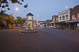
Leighton Gardens
The Moss Vale area was once occupied by the Gandangara people, though they had disappeared by the 1870s, partly due to the loss of their hunting land to European settlers. Governor Hunter sent a party led by ex-convict John Wilson to investigate the area in 1798. Various others explored the area up to 1815, including John Warby, George Caley, Hamilton Hume and John Oxley. Hume, Charles Throsby and Joseph Wild explored the area west of Sutton Forest in 1817 and in 1818, together with James Meehan, they explored the area between Moss Vale and Jervis Bay. Governor Macquarie granted Throsby 1,000 acres (4.0km2), known as Throsby Park, at Bong Bong, on the northeastern outskirts of Moss Vale and put him in charge of building the Old Argyle Road from Sydney to Goulburn in 1819. This road was replaced in the 1830s by a more direct road via Berrima surveyed by Thomas Mitchell and most of the population of Bong Bong moved to Berrima.[2] The heritage-listed property of Throsby Park house was built about 1834, six years after Throsby's suicide.[3]
The area, which was considered to be part of Sutton Forest, remained rural until the coming of the railway. Subdivision part of Throsby Park for the town of Moss Vale, named after Jemmy Moss, a herdsman at Throsby Park, commenced in 1864, in anticipation of the opening of Sutton Forest railway station in 1867 at the intersection with Old Argyle Road. Governor Belmore rented Throsby Park from 1870 to 1872 to what is commonly believed to escape the summer heat of Sydney.[4] The railway and the Robertson Land Acts encouraged denser settlement by selectors in the Southern Highlands and led to the growth of Moss Vale as a town.[5] In 1877 Sutton Forest railway station was renamed Moss Vale.
Climate
Moss Vale has an oceanic climate (Cfb) with warm to mild, rainy summers and cool sunny winters.
Climate data for Moss Vale AWS (2001–2022); 678 m AMSL; 34.53° S, 150.42° E
At the 2021 census, 9,310 people were living in Moss Vale.[11]
According to the 2016 census of Population, there were 8,579 people in Moss Vale. Aboriginal and Torres Strait Islander people made up 2.6% of the population. 78.2% of people were born in Australia. The most common other countries of birth were England 4.4%, New Zealand 1.7% and China 1.5%. 87.2% of people only spoke English at home. Other languages spoken at home included Mandarin at 1.3%. The most common responses for religion were No Religion 25.8%, Anglican 24.9% and Catholic 22.1%.[12]
Moss Vale holds a large part of the Southern Highlands Industry – as well as being a minor centre for agriculture, many light and medium industries are found in and around Moss Vale, including a James Hardie plant, a HarperCollins book distribution centre, and other manufacturing industries. Despite Moss Vale's prowess as an industrial centre, nearby Bowral is the commercial heart of the Southern Highlands.
Moss Vale is believed to have fertile soil and good precipitation. Agricultural rural holdings in the area specialise in dairy herds, mainly Holstein Frisian, and there is an assortment of beef studs and sheep properties.
The Southern Highlands Police Station, part of the Hume Police District is the main NSW Police Force Station serving the Southern Highlands (Wingecarribee Shire). It is located at 67 Elizabeth Street. Moss Vale has a New South Wales Rural Fire Service Brigade which is located at 49 Berrima Road. There is also a Fire and Rescue NSW Station which is located at 64 Elizabeth Street, Moss Vale which is across the road from the Police Station and just up from the Wingecarribee Shire Council Chambers.
Transport
Moss Vale station is the primary southern terminus of the Southern Highlands railway line. The line provides regular services from Moss Vale to southern Sydney, where a change of trains is generally required to access the city centre. Limited services continue south of Moss Vale to Goulburn and beyond (intercity, regional and interstate).
The station has 4 Melbourne XPT services a day (2 to Melbourne, 2 to Sydney), with other services towards Canberra (3 daily trips in each direction) and Griffith (2 return trips per week).
This page is based on this Wikipedia article Text is available under the CC BY-SA 4.0 license; additional terms may apply. Images, videos and audio are available under their respective licenses.