The Nattai National Park is a protected national park that is located in the Macarthur and Southern Highlands regions of New South Wales, in eastern Australia. 48,984-hectare (121,040-acre) It is situated approximately 150 kilometres (93 mi) southwest of the Sydney central business district and primarily encompasses the valley of the Nattai River, which is surrounded by spectacular sandstone cliffs. The park is covered in dry sclerophyll forest - mostly eucalypt, and has fairly frequent forest fires. It is largely an untouched wilderness area and receives very few visitors, as it has virtually no facilities and is fairly remote, despite its proximity to Sydney..

The Southern Highlands, also locally referred to as the Highlands, is a geographical region and district in New South Wales, Australia and is 110 km south-west of Sydney. The entire region is under the local government area of the Wingecarribee Shire. The region is also considered a wine region.

The Division of Throsby was an Australian electoral division in the state of New South Wales. The division was named after Charles Throsby, a prominent pioneer and explorer in the early nineteenth century of the areas to the south of Sydney.

Mittagong is a town located in the Southern Highlands of New South Wales, Australia, in Wingecarribee Shire. The town acts as the gateway to the Southern Highlands when coming from Sydney. Mittagong is situated at an elevation of 635 metres (2,083 ft). The town is close to Bowral, Berrima, Moss Vale and the Northern Villages such as Yerrinbool and Colo Vale. Moreover, Mittagong is home to many wineries of the Southern Highlands which has been a recent growing wine and cellar door region.
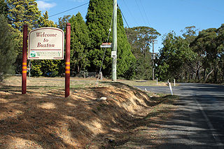
Buxton is a small village in Macarthur Region of New South Wales, Australia, in Wollondilly Shire. At the 2016 census, Buxton had a population of 2,028 people. Its name comes from the town of Buxton, Derbyshire.
Balmoral is a Northern Village of the Southern Highlands area of New South Wales, Australia. It is the northern most village in Wingecarribee Shire.

Ramnagar is a town in Barabanki district in the state of Uttar Pradesh, India. It is a town, tehsil and a nagar panchayat in Barabanki District in the Indian state of Uttar Pradesh.
The Parish of Berrima is a parish of the County of Camden in the Southern Highlands region of New South Wales. Berrima is the largest town in the parish, and the parish includes the land to the north and north-east of this town. The Wingecarribee River forms part of the boundary of the parish in the south, although some of the land near Berrima that is to the south of the river is also included in the parish. Both the old and new Hume Highway pass through the parish from the south-west to the north-east. Gibraltar creek is part of the boundary in the north-east. Bowral and Mittagong are located just to the east of the parish, along with the Southern Highlands railway line. Mandemar is located in the north-west of the parish.
The Parish of Mittagong is a parish of the County of Camden in the Southern Highlands region of New South Wales. It includes the town of Bowral and the southern parts of Mittagong.

The Parish of Colo is a parish of the County of Camden in the Southern Highlands region of New South Wales. It is centred on the town of Colo Vale, and includes Aylmerton, Willow Vale, Alpine and Yerrinbool. It also includes the northern parts of Mittagong that are north of the Old Hume Highway. The new Hume Highway runs through the parish from south-west to north-east.

Justynówka is a village in the administrative district of Gmina Tomaszów Lubelski, within Tomaszów Lubelski County, Lublin Voivodeship, in eastern Poland. It lies approximately 7 kilometres (4 mi) north-east of Tomaszów Lubelski and 107 km (66 mi) south-east of the regional capital Lublin.
Kozubów is a village in the administrative district of Gmina Pińczów, within Pińczów County, Świętokrzyskie Voivodeship, in south-central Poland. It lies approximately 12 kilometres (7 mi) south of Pińczów and 51 km (32 mi) south of the regional capital Kielce.
Wnorów is a village in the administrative district of Gmina Łoniów, within Sandomierz County, Świętokrzyskie Voivodeship, in south-central Poland. It lies approximately 3 kilometres (2 mi) west of Łoniów, 23 km (14 mi) south-west of Sandomierz, and 71 km (44 mi) south-east of the regional capital Kielce.
Fleurs Aerodrome was a parent aerodrome built on behalf of the Royal Australian Air Force during World War II. It is located at Kemps Creek 40 km west of Sydney, Australia
The Jooriland River, a perennial river that is part of the Hawkesbury-Nepean catchment, is located in the Central Tablelands and Macarthur regions of New South Wales, Australia.
Thone River, a perennial stream of the Hastings River catchment, is located in the Mid North Coast region of New South Wales, Australia.

Cave Island is an island marked by a large cavern in its south side, which is the second largest of the Meade Islands lying in the north entrance to McFarlane Strait, off Archar Peninsula on Greenwich Island in the South Shetland Islands. It is separated from neighbouring Zverino Island to the west-southwest by the 110 m wide Glogovo Passage.
Fivebough and Tuckerbil Wetlands are two wetland sites within the Riverina and Murrumbidgee Irrigation Area (MIA), near Leeton in New South Wales, Australia. Both Fivebough and Tuckerbil sites form Crown reserve number 1030008 managed by NSW Department of Industry, for ecological conservation and public recreation. The reserve was recognised as being a Wetland of International Importance through designation under the Ramsar Convention on 21 October 2002 as Ramsar Site 1224
Persoonia glaucescens, commonly known as the Mittagong geebung, is a shrub native to New South Wales in eastern Australia. It was formerly known as Persoonia lanceolata subspecies B. It is currently classified under Commonwealth legislation as vulnerable, and is listed in New South Wales legislation as endangered.
Pukeko Pond is a pond, 0.25 nautical miles (460 m) long, between Mount Loke and the west side of Denton Glacier in the Asgard Range, McMurdo Dry Valleys. Named by the New Zealand Geographic Board in 1998 after a New Zealand water bird.