Related Research Articles

The Wingecarribee River, a perennial river that is part of the Hawkesbury–Nepean catchment, is located in the Southern Highlands region of New South Wales, Australia.

The Southern Highlands, also locally referred to as the Highlands, is a geographical region and district in New South Wales, Australia and is 110 km south-west of Sydney. The region comprises the local government area of the Wingecarribee Shire and also towns of the Mulwaree Shire. The region is also considered a wine region.
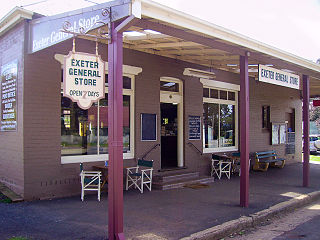
Exeter is a village in the Southern Highlands district of New South Wales, Australia, in Wingecarribee Shire. It has a station on the Main Southern railway line south of Sydney.

Bowral is the largest town in the Southern Highlands of New South Wales, Australia, about ninety minutes southwest of Sydney. It is the main business and entertainment precinct of the Wingecarribee Shire and Highlands.

Mittagong is a town located in the Southern Highlands of New South Wales, Australia, in Wingecarribee Shire. The town acts as the gateway to the Southern Highlands when coming from Sydney. Mittagong is situated at an elevation of 635 metres (2,083 ft). The town is close to Bowral, Berrima, Moss Vale and the Northern Villages such as Yerrinbool and Colo Vale. Moreover, Mittagong is home to many wineries of the Southern Highlands which has been a recent growing wine and cellar door region.

Moss Vale is a town in the Southern Highlands of New South Wales, Australia, in the Wingecarribee Shire. It is located on the Illawarra Highway, which connects to Wollongong and the Illawarra coast via Macquarie Pass.
John Horbury Hunt, often referred to as Horbury Hunt, was a Canadian-born Australian architect who worked in Sydney and rural New South Wales from 1863.
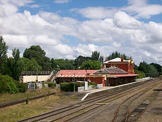
Moss Vale railway station is a heritage-listed railway station on the Main Southern line in New South Wales, Australia. It serves the town of Moss Vale. It opened on 2 December 1867 as Sutton Forest, being renamed in 1877. It was added to the New South Wales State Heritage Register on 2 April 1999.

Picton is a small town in the Macarthur Region of New South Wales, Australia, in the Wollondilly Shire, in south-western Sydney. The town is located approximately 90 kilometres south-west of the Sydney CBD, close to Camden and Campbelltown. It is also the administrative centre of Wollondilly Shire.

Wingello is a village in the Southern Highlands of New South Wales, Australia. It has a station on NSW TrainLink's Southern Highlands Line. The surrounding area is part of the lands administrative unit of the Wingello Parish, a subdivision of Wingecarribee Shire.

Yerrinbool is one of the Northern Villages of the Southern Highlands of New South Wales, Australia, in the Wingecarribee Shire, and is accessible from the Hume Highway and is about a 12 km (7.5 mi) drive from nearby Mittagong. It is 7 km (4.3 mi) to Hill Top as the crow flies, accessible by foot via a fire trail. It is on the western edge of the Upper Nepean Nature Reserve, a vast area of forest, lakes and dams between Yerrinbool and the coastal communities around Wollongong. Yerrinbool was previously officially known as the Town of Yerrinbool. It is located on the historic Old Hume Highway.
Bargo is a town in the Macarthur Region of Sydney in New South Wales, Australia, in the Wollondilly Shire. It is located approximately halfway between Campbelltown and Bowral, about 100 km south west of the Sydney CBD.

The Parish of Bong Bong is a parish of the County of Camden in the Southern Highlands region of New South Wales. Moss Vale is the largest town in the area. The parish includes the small township of Bong Bong, which was the first village established in the Southern Highlands. The Wingecarribee River forms part of the boundary of the parish in the north and north-east. The Hume Highway passes through a small part of the parish in the north-west. Bowral is just beyond the boundary of the parish in the north-east. Berrima is located just to the north-west. The Illawarra Highway passes through the parish from east to west, and is also a small part of the boundary in the south-west.
Bowral is a town in the Southern Highlands of New South Wales, Australia. It has a history spanning nearly 200 years.
White Horse Inn is a heritage-listed former residence, inn, bank and restaurant at Market Street, Berrima, Wingecarribee Shire, New South Wales, Australia. It was built from 1834 to 1850 by Edward Davies. It is also known as Commercial Bank of Australia, Rosebank, Oldbury's Inn, Holsberry Inn, Mail Coach Inn, and Royal Mail Coach Inn. It was added to the New South Wales State Heritage Register on 2 April 1999.

St Francis Xavier's Roman Catholic Church is a heritage-listed Catholic church at Hume Highway, Berrima, Wingecarribee Shire, New South Wales, Australia. It was designed by Augustus Pugin and built from 1849 to 1851 by William Munro. Originally known as St. Scholastica's Church, it is used by the Parish of St. Paul, administered by the Pauline Fathers, and located in the Diocese of Wollongong. It was added to the New South Wales State Heritage Register on 25 January 2008.

Berrima Post Office is a heritage-listed post office at Argyle Street, Berrima, Wingecarribee Shire, New South Wales, Australia. It was built in 1886 by R. N. Matthews. It was added to the New South Wales State Heritage Register on 2 April 1999.

Holy Trinity Anglican Church is a heritage-listed Anglican church at Argyle Street, Berrima, Wingecarribee Shire, New South Wales, Australia. It was designed by Edmund Blacket and built from 1849. The property is owned by the Anglican Church Property Trust. It was added to the New South Wales State Heritage Register on 2 April 1999.
Berrima Inn is a heritage-listed residence and former inn, cafe, craft shop and restaurant at Jellore Street, Berrima, Wingecarribee Shire, New South Wales, Australia. It was built by Brian McMahon. It is also known as McMahon's Inn. It was added to the New South Wales State Heritage Register on 2 April 1999.

Christ Church is a heritage-listed Anglican church located on Bong Bong Road, Bong Bong, in the Wingecarribee Shire local government area of New South Wales, Australia. It was built in 1845 at the behest of Charles Throsby, possibly by convict labour. The design of the church has been attributed to John Verge. The church site includes an associated cemetery. It was added to the New South Wales State Heritage Register on 7 April 2000.
References
- ↑ "Christ Church, Churchyard & Cemetery". New South Wales State Heritage Register . Department of Planning & Environment. H01383. Retrieved 18 May 2018.
 Text is licensed by State of New South Wales (Department of Planning and Environment) under CC-BY 4.0 licence .
 - ↑ Bong Bong station. NSWrail.net, accessed 9 August 2009.
- Exploring the ACT and Southeast New South Wales, J. Kay McDonald, Kangaroo Press, Sydney, 1985 ISBN 0-86417-049-1