Wingham Brush Nature Reserve

Last updated

Wingham Brush Nature Reserve
New South Wales
IUCN category IV (habitat/species management area)
Wingham Brush with Moreton Bay Fig.jpg
Moreton Bay fig, located in the reserve
Australia New South Wales relief location map.png
Red pog.svg
Wingham Brush Nature Reserve
Nearest town or city Wingham
Coordinates 31°52.2′S152°22.8′E / 31.8700°S 152.3800°E / -31.8700; 152.3800
EstablishedJuly 2000 (2000-07) [1]
Area0.08 km2 (0.0 sq mi) [1]
Managing authorities NSW National Parks and Wildlife Service
Website Wingham Brush Nature Reserve
See also Protected areas of
New South Wales

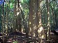
The Wingham Brush Nature Reserve is a protected nature reserve that is located in the Mid North Coast region of New South Wales, in eastern Australia. The 8-hectare (20-acre) reserve is a rare [2] example of sub tropical lowland rainforest and is situated on the Manning River.

Contents

Features

Much of Australia's lowland sub tropical rainforest was cleared for housing and agriculture, leaving only small patches remaining, such as at Wingham Brush The soils are derived from the Manning River. These alluvial soils are enriched from basaltic deposits upstream at Barrington Tops and the Comboyne and Bulga Plateaux. The average annual rainfall is 1,100 millimetres (43 in) at Wingham. [3]

Fauna

The most obvious mammal species in the rainforest is the grey-headed flying fox. Many other species of bats occur here too. Noteworthy birds occurring here include the osprey, green catbird, wompoo fruit-dove and brush turkey. Nocturnal gliders and possums occur in the rainforest, as do many species of reptiles, such as the land mullet. [4]

Flora

The reserve contains 76 species of trees. Most evident in Wingham Brush are the large Moreton Bay figs. Another very common plant is the giant stinging tree. The largest known blush walnut was measured at 37 metres tall, with a base of over a metre wide. Other significant tree species include white cedar, black apple, white walnut, shiny-leaved stinging tree, native elm, hairy rosewood and black booyong.

Rainforest regeneration

Rainforest regeneration programmes have been put in place to encourage local rainforest species and suppress the problem of invasive weeds. [5] The forest was badly infested with weeds until local residents decided to act in 1980. The vines Madeira vine and cats claw creeper were particularly damaging. After the cleanup, the previously degraded area was transformed back into pristine rainforest. The "Wingham Brush method" is an internationally recognised technique for rainforest regeneration.[ citation needed ]

Indigenous Australians

Wingan in the local indigenous Biripi language means "where bats come to drink". [4] Indigenous Australians regularly visited the rainforest for the collection of food, medicinal purposes, the collection of fibres for making bags and nets and social gatherings. The rainforest has spiritual significance to local indigenous people.

See also

Related Research Articles

<span class="mw-page-title-main">Biriwal Bulga National Park</span> Protected area in New South Wales, Australia

Biriwal Bulga National Park is an Australian national park in New South Wales. It is approximately 45 km north west of Taree and 60 km west of Port Macquarie on the Bulga Plateau.

Bush regeneration, a form of natural area restoration, is the term used in Australia for the ecological restoration of remnant vegetation areas, such as through the minimisation of negative disturbances, both exogenous such as exotic weeds and endogenous such as erosion. It may also attempt to recreate conditions of pre-European arrival, for example by simulating endogenous disturbances such as fire. Bush regeneration attempts to protect and enhance the floral biodiversity in an area by providing conditions conducive to the recruitment and survival of native plants.

<span class="mw-page-title-main">Wingham, New South Wales</span> Town in New South Wales, Australia

Wingham is a town in the Mid North Coast region of New South Wales, Australia in the Mid-Coast Council area 329 kilometres (204 mi) north of Sydney. According to the 2021 census, Wingham had a population of 5,395.

The Big Scrub was the largest area of lowland subtropical rainforest in eastern Australia. It was intensively cleared for agricultural use in the 19th century (1801–1900) by settlers. Less than 1% now remains.

Nameless Sylvan Reserve is a 54-hectare (130-acre) nature reserve on the Illawarra Escapment of south-eastern New South Wales, Australia. It is 10 kilometres (6.2 mi) north of Berry, and close to the Barren Grounds Nature Reserve. It is owned and managed by Bush Heritage Australia (BHA), to which it was donated in 2007 by Louise Sylvan.

<span class="mw-page-title-main">Boorganna Nature Reserve</span> Protected area in New South Wales, Australia

The Boorganna Nature Reserve is a protected nature reserve located northwest of Taree on the Comboyne Plateau in New South Wales, Australia. The 396-hectare (980-acre) reserve, managed by the NSW National Parks & Wildlife Service, was gazetted in 1904 and is the second oldest nature reserve in the state. The reserve features various forest types, including stands of sub tropical rainforest of which the large rosewood, yellow carabeen and small leaf fig are particularly noteworthy. The reserve is a remnant of the former extensive rainforest on the Comboyne Plateau. The plateau was cleared between 1900 and 1925. Australian red cedar was logged in the area in the nineteenth century. Originally proposed to be part of the world heritage rainforest group. The exploration, knowledge, uses and history of this area by Indigenous Australians is not well known in the present day. Boorganna Nature Reserve was proposed, but rejected for inclusion on the UNESCO World Heritage, due to being geographically isolated from other rainforests in the group.

<span class="mw-page-title-main">Victoria Park Nature Reserve</span> Protected area in New South Wales, Australia

The Victoria Park Nature Reserve is a protected nature reserve that is located in the Northern Rivers region in the state of New South Wales, in eastern Australia. The sub-tropical jungle remnant is located an undulating high rainfall plain near Alstonville. The red-brown soil is derived from a basaltic flow from the nearby Mount Warning. Of the total land in the reserve, 8 hectares is original rainforest; and the other areas are being re-vegetated.

<span class="mw-page-title-main">Robertson Nature Reserve</span> Protected area in New South Wales, Australia

The Robertson Nature Reserve is a protected rainforest nature reserve that is located in the Southern Highlands region of New South Wales, in eastern Australia. The 5.3-hectare (13-acre) reserve is situated near Robertson on the edge of the Illawarra Escarpment and is a remnant of the Yarrawa Brush, once 2,450 hectares in size.

<span class="mw-page-title-main">Susan Island Nature Reserve</span> Protected area in New South Wales, Australia

The Susan Island Nature Reserve is a protected 23-hectare (57-acre) reserve nature reserve located at the western (upstream) end of the 90ha Susan Island, a 2.5km long x 420m wide river island, that is located in the Clarence River, in the Northern Rivers region of New South Wales in eastern Australia near the centre of Grafton. The rainforest of the nature reserve and adjoining crown land is a rare 19-hectare (47-acre) example of sub tropical lowland rainforest on floodplain, and is listed under the NSW Biodiversity Conservation Act as an Endangered Ecological Community.

<span class="mw-page-title-main">Coocumbac Island Nature Reserve</span> Protected area in New South Wales, Australia

The Coocumbac Island Nature Reserve is a protected nature reserve located in the mid–north coast region of New South Wales, Australia. The 6-hectare (15-acre) reserve, situated on the Manning River near Taree, is a rare example of a subtropical lowland rainforest.

<span class="mw-page-title-main">Sea Acres National Park</span> Protected area in New South Wales, Australia

The Sea Acres National Park is a national park that is located in the Mid North Coast region of New South Wales, in eastern Australia. The 76-hectare (190-acre) park is situated near the town of Port Macquarie. The park is a popular tourist area with a 1.3-kilometre (0.81 mi) long boardwalk through a remnant of seaside rainforest. There is also an education centre and cafe. The park was initially declared as a nature reserve in 1987; and gazetted as a national park in October 2010.

<span class="mw-page-title-main">Gamilaroi Nature Reserve</span> Protected area in New South Wales, Australia

The Gamilaroi Nature Reserve is a protected nature reserve, part of the southern Brigalow Belt, that is located in the North West Slopes region of New South Wales, in eastern Australia. The 113-hectare (280-acre) reserve is situated 48 kilometres (30 mi) southeast of Moree, and about 6 kilometres (3.7 mi) south of Terry Hie Hie, at an elevation of 340 metres (1,120 ft) above sea level. The reserve is one of seven sites in the state where ooline occurs naturally. For this reason, the reserve is not promoted for recreation; and visits are not encouraged.

<span class="mw-page-title-main">Broken Head Nature Reserve</span> Protected area in New South Wales, Australia

The Broken Head Nature Reserve is a protected nature reserve located in the Northern Rivers region of New South Wales, Australia, adjacent to the promontory of Broken Head which lies approximately 9 km south of Cape Byron, the easternmost point of Australia. The 98-hectare (240-acre) reserve contains an intact segment of littoral rainforest. Much of the Australian littoral rainforests have been destroyed for agriculture, mining or housing. Species of tree include Tuckeroo, Broad-leaf Lilly Pilly, Native Elm, Pear Fruited Tamarind, Bennett's Ash, Bangalow Palm, Rusty Rose Walnut and Hoop Pine. The extremely rare Scented Acronychia may naturally occur here. Climbers such as Whip Vine and Lawyer Cane are very common. The weed lantana is a serious problem in disturbed areas. The area is noted for its Aboriginal culture, rainforest walks, whale watching, and fishing from pristine beaches.

<span class="mw-page-title-main">Stotts Island Nature Reserve</span> Protected area in New South Wales, Australia

The Stotts Island Nature Reserve is a protected nature reserve containing the Stotts Island, a river island, that is located in the Tweed River, in the Northern Rivers region of New South Wales in eastern Australia. The 141-hectare (350-acre) reserve is situated near Tweed Heads and 12 kilometres (7.5 mi) northeast of Murwillumbah.

<span class="mw-page-title-main">Ukerebagh Island</span> Protected area in New South Wales, Australia

The Ukerabagh Island is a river island in the Ukerabagh Island Nature Reserve, a protected nature reserve. It is located in the mouth of the Tweed River, in the Northern Rivers region of New South Wales in eastern Australia. The 125-hectare (310-acre) reserve is situated near Tweed Heads and 1 kilometre (0.62 mi) south of a section that defines the border between the states of New South Wales and Queensland. The island and reserve is an important site for coastal birds.

<span class="mw-page-title-main">Littoral Rainforests of New South Wales</span>

The Littoral Rainforests of New South Wales is a group of fragmented and endangered ecological communities found by the coast in eastern Australia. Much of this seaside form has been destroyed by mining, tourist development or housing. It is threatened by extinction in the near future. 90% of the 433 sites are less than ten hectares in size. Littoral rainforest amounts to 0.6% of the rainforests in New South Wales.

The Kangaroo River Nature Reserve, part of the Kangaroo Valley Group of Nature Reserves, is a protected nature reserve that is located on the floor of the Kangaroo Valley in the Southern Highlands and South Coast regions of New South Wales in eastern Australia. The reserve is situated approximately 150 kilometres (93 mi) south of Sydney, 50 kilometres (31 mi) southwest of Wollongong and 16 kilometres (9.9 mi) northwest of Nowra. The reserve has a protective covenant placed upon it with purpose to ensure the protection of the natural heritage of this area. National parks in the area include the Morton National Park and the Budderoo National Park. Other nature reserves in the area include the Barren Grounds Nature Reserve, and the Cambewarra Range, Barrengarry and Rodway nature reserves – the latter three part of the Kangaroo Valley Group of Nature Reserves.

<span class="mw-page-title-main">Coramba Nature Reserve</span> Protected area in New South Wales, Australia

Coramba Nature Reserve is a protected nature reserve located near Coffs Harbour in the Mid North Coast region of New South Wales, Australia. It is one of the few remnants of low altitude sub tropical rainforest in the Clarence River valley. Founded in 1982 with the primary goal of protecting the remaining lowland rainforests.

<span class="mw-page-title-main">Wallumatta Nature Reserve</span> Protected area in New South Wales, Australia

Wallumatta Nature Reserve, also called the Macquarie Hospital Bushland, is a 6-hectare (15-acre) nature reserve bushland area, surrounded by the residential suburb of East Ryde, in suburban Sydney, Australia. Once part of the Field of Mars of 1804, the reserve is the largest surviving area of Sydney Turpentine-Ironbark Forest, an endangered ecosystem. Soils are based on Ashfield Shale and Hawkesbury Sandstone.

<span class="mw-page-title-main">Limeburners Creek National Park</span> Protected area in New South Wales, Australia

Limeburners Creek National Park is a protected national park on the Mid North Coast of New South Wales, Australia. The 91.2 km national park is located 5 km (3.1 mi) to the north of Port Macquarie and exists across both the Kempsey Shire and Port Macquarie-Hastings Council local government areas, but is chiefly managed by National Parks and Wildlife Service. The area was originally erected as a nature reserve but this reservation was revoked when it became formally recognised as a national park in 2010 under the National Parks and Wildlife Act (1974). Many threatened ecological habitats and species of fauna and flora are found within this park, alongside several heritage sites of cultural significance, particularly to the local Birpai and Dunghutti people upon whose land the park exists. The protected status of this national park is largely owing to the ecological and cultural value of the area, in addition to the value of the ecosystems to further scientific research.

References

  1. 1 2 "Wingham Brush Nature Reserve: Park management". Office of Environment and Heritage. Government of New South Wales . Retrieved 27 September 2014.
  2. "Lowland rainforest on floodplain in the NSW North Coast Bioregion - endangered ecological community listing". Government of New South Wales.
  3. Stockard, J. D. (1996). Rainforest Regeneration at Wingham Brush 1980-1996 (PDF). Eleventh Australian Weeds Conference Proceedings (PDF).
  4. 1 2 "Wingham Brush Nature Reserve: Pamphlet". NSW National Parks and Wildlife Service (PDF). Government of New South Wales. August 2011.
  5. Floyd, A. G. (1990). Australian Rainforests of New South Wales. Vol. 2. ISBN   0-949324-32-9.