
The Brisbane Water National Park is a protected national park that is located in the Central Coast region of New South Wales, in eastern Australia. The 11,506-hectare (28,430-acre) national park is situated 47 kilometres (29 mi) north of Sydney, 10 kilometres (6.2 mi) west of Woy Woy, and 12 kilometres (7.5 mi) southwest of Gosford.

Kings Plains is a national park in New South Wales, Australia, 48 km from Inverell, 50 km from Glen Innes and 478 km north of Sydney.
The Mallee Cliffs National Park is a protected national park that is located in the Sunraysia region, in the south-west of New South Wales, Australia. The 57,969-hectare (143,240-acre) national park is situated approximately 790 kilometres (490 mi) west of Sydney and 30 kilometres (19 mi) east of the Murray River city of Mildura, Victoria.

Jarrah Forest is an interim Australian bioregion located in Western Australia. The Jarrah Forest comprises reserves across the south-west corner of WA and is managed for uses including recreation. There are many small areas of parkland while larger protected areas include the Dryandra Woodland, Lane-Poole Reserve, and the Perup Forest Ecology Centre. Also managed for land uses such as water, timber and mineral production, recreation and conservation, the forest is recognised globally as a significant hotspot of plant biodiversity and endemism.

Established in 1965, the Yellingbo Nature Conservation Reserve is located 45 km east of Melbourne in the Upper Yarra Valley, near the towns of Yellingbo, Launching Place, Yarra Junction, Hoddles Creek, Cockatoo, Emerald, Monbulk and Seville. Yellingbo Nature Conservation Reserve is a narrow riparian reserve with stream-frontage land along the Woori Yallock, Shepherd, Cockatoo, Macclesfield and Sheep Station Creeks.

The Yathong Nature Reserve is a protected nature reserve that is also a nationally and internationally recognized biosphere situated in the central-western region of New South Wales, in eastern Australia. The 107,240-hectare (265,000-acre) reserve was listed by UNESCO in 1977 as a Biosphere Reserve under the Man and the Biosphere Programme (MAB). The reserve is significant for its biodiversity in both native plant and animal species. Cultural heritage and historical grazing activities add to the significance of this site as a conservation area.
The Castlereagh Nature Reserve is a protected nature reserve located in the western suburbs of Sydney in New South Wales, Australia. The 495-hectare (1,220-acre) reserve is situated 60 kilometres (37 mi) west of the central business district, approximately 10 kilometres (6.2 mi) north-east of Penrith and located near the townships of Castlereagh and Londonderry. In 1960, 266 hectares was reclaimed for use as a Child Welfare Training School, and in 1971, 389 hectares was reclaimed for the establishment of a liquid waste disposal facility.
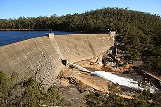
The Burrinjuck Nature Reserve is a protected nature reserve on the south west slopes of New South Wales, Australia. The 5,250-hectare (13,000-acre) reserve is located adjacent to the Burrinjuck Dam, with 5,118 hectares of the reserve located on the northern side of the reservoir, and the remaining 89 hectares located on the southern side of the reservoir to the northeast of Black Andrew Nature Reserve. It includes land formerly managed as the Burrinjuck State Forest and Burrinjuck State Recreation Area.
The Queanbeyan Nature Reserve is a protected nature reserve that is located in the Southern Tablelands region of New South Wales, in eastern Australia. The 67-hectare (170-acre) reserve is situated approximately 4 kilometres (2.5 mi) west-south-west of the City of Queanbeyan.

The Charcoal Tank Nature Reserve is a protected nature reserve in the central western region of New South Wales, Australia. The 86.4-hectare (213-acre) reserve is situated 10 kilometres (6.2 mi) south of West Wyalong and may be accessed via the Newell Highway and The Charcoal Tank Road. The reserve is an important refuge for native flora and fauna in a highly fragmented landscape, one in which the majority of the original vegetation has been removed.
Boginderra Hills Nature Reserve is a protected nature reserve situated to the north of Temora, located in the Riverina region of New South Wales in eastern Australia. It has an area of 756 hectares.
Ingalba, Big Bush and Pucawan Nature Reserves are three Nature Reserves situated to the west of Temora, New South Wales. Ingalba Nature Reserve is situated 10 kilometres west of Temora and Pucawan Nature Reserve a further 6 km west. Big Bush Nature Reserve is 15 kilometres northwest of Temora. All three reserves are located within Temora Shire. They are managed concurrently by the New South Wales Parks and Wildlife Service. The reserves are linked by corridors of vegetation in adjacent private land and along roads and Travelling Stock Routes.

Persoonia terminalis, also known as the Torrington geebung, is a rare shrub belonging to the family Proteaceae, and native to northern New South Wales and southern Queensland in eastern Australia. Reported as a subspecies of Persoonia nutans in 1981, it was described as a species by Lawrie Johnson and his colleague Peter Weston in 1991.
Caravan Head Bushland Reserve is a reserve approximately 2.2ha located in Sutherland Shire, southern Sydney, in the state of New South Wales, Australia.

The Cumberland Plain Woodland is one of six main indigenous woodland communities of Sydney, New South Wales, Australia, that comprises an open tree canopy, a groundcover with grasses and herbs, usually with layers of shrubs and/or small trees. Situated in the Cumberland Plain, it is made up of dry sclerophyll woodlands, grasslands and/or forests, reminiscent of Mediterranean forests and temperate grasslands.

Scabby Range Nature Reserve is a heritage-listed protected area at Sams River Fire Trail, Yaouk, New South Wales, Australia. It was established on 3 December 1982 and added to the former Australian Register of the National Estate on 30 June 1992. It was added to the Australian National Heritage List as part of the Australian Alps National Parks and Reserves on 7 November 2008.

The Agnes Banks Natural Area is a heritage-listed natural sand deposit, fauna habitat and native flora site at Rickards Avenue in the western Sydney suburb of Agnes Banks in the City of Penrith local government area of New South Wales, Australia. It is also known as The Natural Area and Agnes Banks Sand Deposits. The property is owned by CSR Limited and the NSW Office of Environment and Heritage. It was added to the New South Wales State Heritage Register on 2 April 1999.

Pooginook Conservation Park is a protected area located in the Australian state of South Australia in the locality of Pooginook about 166 kilometres (103 mi) north-east of the state capital of Adelaide and about 12 kilometres (7.5 mi) north-east of the town of Waikerie.
Wellington National Park is a national park in Western Australia, located 10 kilometres (6 mi) west of Collie and approximately 215 km (134 mi) south of Perth in the Shire of Collie along the Coalfields Highway.

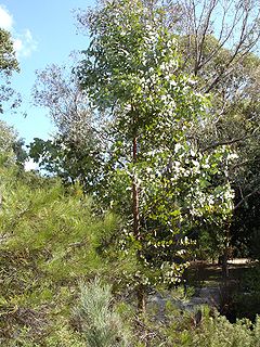
The ecology of Sydney, located in the state of New South Wales, Australia, is diverse for its size, where it would mainly feature biomes such as grassy woodlands and some sclerophyll forests, with a few pockets of mallee shrublands, subtropical and temperate rainforests (evergreen), heathlands, and wetlands. The combination of climate, topography, moisture, and soil influence the dispersion of these ecological communities across a height gradient from 0 to 200 metres. There are many hiking trails, paved and unpaved roads for exploring the many different biomes and ecosystems.

