Kangaroo River Nature Reserve

Last updated

Kangaroo River Nature Reserve
New South Wales
Australia New South Wales relief location map.png
Red pog.svg
Kangaroo River Nature Reserve
Nearest town or city Kangaroo Valley
Coordinates 34°43′50″S150°27′12″E / 34.73056°S 150.45333°E / -34.73056; 150.45333 Coordinates: 34°43′50″S150°27′12″E / 34.73056°S 150.45333°E / -34.73056; 150.45333
EstablishedJanuary 2001 (2001-01) [1]
Area1.26 km2 (0.5 sq mi) [1]
Managing authorities NSW National Parks and Wildlife Service
Website Kangaroo River Nature Reserve
See also Protected areas of
New South Wales

The Kangaroo River Nature Reserve, part of the Kangaroo Valley Group of Nature Reserves, is a protected nature reserve that is located on the floor of the Kangaroo Valley in the Southern Highlands and South Coast regions of New South Wales in eastern Australia. The reserve is situated approximately 150 kilometres (93 mi) south of Sydney, 50 kilometres (31 mi) southwest of Wollongong and 16 kilometres (9.9 mi) northwest of Nowra. [2] The reserve has a protective covenant placed upon it with purpose to ensure the protection of the natural heritage of this area. National parks in the area include the Morton National Park and the Budderoo National Park. Other nature reserves in the area include the Barren Grounds Nature Reserve, and the Cambewarra Range, Barrengarry and Rodway nature reserves the latter three part of the Kangaroo Valley Group of Nature Reserves. [2]

Contents

Features

Reserves are a proactive approach to ensure environmental stressors can be removed which can avoid potential decline and extinction of the more vulnerable species but species that are common within a wide range of environmental conditions can still be susceptible to environmental changes resulting in their local decline or extinction. [3] The National Trust have also listed the Kangaroo Valley, Barrengarry, Kangaroo River and parts of the Rodway and Camberwarra Range nature reserves as Scenic Protection Areas. The reserves help to protect areas of significance that are home to many communities, rainforest, deep gullies, waterfalls, cliffs with places of distinct beauty [2]

Ecology

There is an overlap of habitats of the coastal areas to east and the tablelands to the west with microhabitats created by the differing vegetation, creeks and rocky regions. These protected areas provide habitat that is of high quality for flora and fauna species. [4] The reserves are covered by the Southern Regional Forest Agreement. Even though many reserves are not in themselves large, it is considered necessary to maintain viable populations with the beneficial supplementary nature of the smaller reserves which cannot be understated and in many cases may be the only option for the management of species under stressors that threaten survival. [5] Kangaroo Valley is made up of wet sclerophyll forests, heath lands and rainforest. The rainforests are mainly in the gullies and creaks of the valley; with an abundance of cabbage tree palms ( Livistona australis ), epiphytes of birds-nest ( Asplenium nidus ) and tree ferns (Cyatheales). The leafless tongue orchid ( Cryptostylis hunteriana ) is considered vulnerable with sightings of this plant between Batemans Bay and Nowra. [4]

One plant that exists adjacent to the Kangaroo River reserve is the Illawarra stinking arum ( Typhonium eliosurum). This plant has been listed as a Rare or Threatened Australian Plant (RoTAP).

Most of the vegetation contained within the reserves in Kangaroo Valley with the exception of the Kangaroo River Nature Reserve, is mature, old growth forest. Previous logging activity, fires and gravel extraction within the Kangaroo River Nature reserve have created areas of disturbance with small regrowth areas that is evident in parts.

Fauna

Below is a list of birds, amphibians and mammals that have been sighted within the reserves and are listed in the NSW Threatened Species Conservation Act 1995.

Birds

Eastern bristlebird (Dasyornis brachypterus brachypterus) Bristlebirds.jpg
Eastern bristlebird (Dasyornis brachypterus brachypterus)

Eastern bristlebird (Dayornis brachypterus brachypterus), swift parrot (Lathamus discolour), powerful owl (Ninox strenua), sooty owl (Tyto tenebricosa), olive whistler (Pachycephala olivacea), regent honeyeater (Xanthomyza Phrygia), turquoise parrot (Neophema pulchella) and the Australian masked owl (Tyto novaehollandiae).

Amphibians

There is just the one amphibian the giant burrowing frog that is represented in the NSW Threatened Species Conservation Act 1995, with 2 reptiles listed also; the broad-headed snake and the heath monitor.

Mammals

Brush-tailed rock wallaby (Petrogale penicillata) Brush-tailed Rock-wallaby.jpg
Brush-tailed rock wallaby (Petrogale penicillata)

Also on the list contained in the act are seven mammals. They are the; brushed tailed rock-wallaby (Petrogale penicullata), yellow-bellied glider (Petaurus australis), spotted-tailed quoll (Dasyurus maculates), long-nosed potoroo (Potoous trudactylus), eastern bent-wing bat (Miniopterus schreidersii), smoky mouse (Pseudomys fumeus), greater broad-nosed bat (Scoteanax rueppellii).

The yellow-bellied glider (Petaurus australis) and eastern bristlebird (Dasyornis brachypterus) are amongst other local fauna species that are considered regionally endangered. It is integral to the continued survival of the yellow-bellied glider that the sap trees that are used by the glider as well as non-sap trees such as the grey gum (Eucalyptus punctata) are conserved.

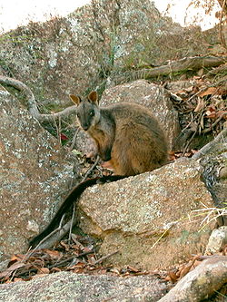
As the eastern bristlebird (Dasyornis brachypterus brachypterus) naturally inhabits the ground areas of dense fire prone areas, the primary reason for their population decline can be associated with fire, habitat loss and nest desertion. [6] This then in turn indicates a need for great care to be taken in fire management in places there is eastern bristlebird habitation and to make sure there is unburned vegetation left to allow remaining birds a refuge [7] One of the locally endangered species is the brush-tailed wallaby. This wallaby survives on naturally fragmented areas of rocky outcrops in small groups to a maximum of about 30 individuals [8]

Flora

The four reserves are home to five vegetation types; heathland, open forest, rainforest and tall moist forest. The areas vegetation is greatly affected by differing soil types and can be seen in the species taking advantage of the fertile volcanic areas, whilst the sandstone, siltstone and mudstone areas contain species that are more tolerant to shallow soils and water scarcity.

Species of note in the Kangaroo River Nature reserve are; scribbly gum (Eucalyptus sclerophylls), red bloodwood (Corymbia polycarpa) and grey gum (E. punctata). This reserve has in the past been used for grazing with a section of the north western area used to extract gravel for the construction of the Bendeela and Tallowa Dam roads. Regrowth from previous uses can be observed in this reserve.

Rodway Nature reserve has similar species, however, there are species specific to Rodway Reserve, such as; Sydney peppermint (E. piperita), silvertop ash (E. sieberi), turpentine (Syncarpia glomulifera), brown barrel (E. fastigata), white topped box (E. quadranulata), river peppermint (E. elata), flax leaf paperbark (Melaleuca linariifolia), yellow tea tree (Leptospermum polygalifolium) and currant bush (Leptomeria acida).

Turpentine (Syncarpia glomulifera) Gardenology.org-IMG 2299 rbgs11jan.jpg
Turpentine (Syncarpia glomulifera)

The Cambewarra Range Nature reserve is the largest of these reserves being 1684 hectares of mostly old growth forest and shares certain species with some of the other reserves, but have some species of note that are more prevalent in this reserve. They are: coachwood (Ceratopetalum apetalum), sassafras (Doryphora sassafras), Lilly pilly (Syzgium smithii) and native laurel (Cryptocarya glaucescens).

The endangered shrub species Solanum celatum has also been recorded on the Cambewarra Range reserve, whilst the vulnerable, furred tongued orchid (Cryptostylis hunteriana) has been found at an area within the Cambewarra Range reserve called the Red Rock plateau.

Barrengarry Nature reserve has a remnant area of 21 hectares (52 acres) and contains the following tree species; Sydney blue gum-bangalay (Eucalyptus saligna), turpentine (Syncarpia glomulifera), spotted gum (Corymbia maculate), and the blackbutt (Eucalyptus pilularis).

Environmental threats

Fox (Vulpes vulpes vulpes) Vulpes vulpes 1.jpg
Fox (Vulpes vulpes vulpes)

The major threats to most of the plant and animal species in the valley are development, fire and introduced species. The Kangaroo River Nature Reserve was used for gravel extraction in the building of roads. It was also used for grazing.

Within the nature reserves of Barrengarry, Roday and Cambewarra Range reserve areas the threats from human settlement started with the logging of red cedar (Toona ciliate) trees in the early 1800s [9] This was then followed by clearing of the forests for agricultural reasons.

Weeds and introduced fauna species such as foxes, feral goats and rabbits continue to be a problem. Edge effects occur where the reserves are next to areas of cleared forest allowing the proliferation of weeds and the incursion of stock and feral animals.

Bushfire prevention policies such as indiscriminate burning and the construction of roads, which cut through formally closed rainforest environments, are considerably damaging [9]

Kangaroo Valley is a popular holiday recreational area which has also been known to put pressures on the natural areas by supporting tourist services such as campsites and walking trails.

Management

The National Parks and Wildlife Act 1974 No.80 Part 5 is instrumental in the formation of management plans to ensure the protection of remnant areas of forest, endangered, critically endangered and vulnerable species and ecological communities. The Kangaroo Valley group of nature reserves has one such management plan. Section 72AA, of the National Parks and Wildlife Act 1974 No. 80, ‘Objective and content of the plans of management’, contains all matters that are required to be taken into consideration when constructing plans of management.

Environmental groups such as the Kangaroo Valley Environment Group Incorporated are vitally important in the maintenance and continued management of the reserves. They receive support and financial grants from various government agencies such as the Sydney Catchment Authority, Shoalhaven City Council and Shoalhaven Landcare Association. The other Landcare groups in the area are the Broger's Creek Landcare group, the Upper Kangaroo Valley Landcare Group, the Friends of the brush-tailed rock wallaby and the Kangaroo Valley Garden Group.

See also

Related Research Articles

<span class="mw-page-title-main">South Bruny National Park</span> Protected area in Tasmania, Australia

The South Bruny National Park is a national park located on Bruny Island, Tasmania, Australia, about 50 kilometres (31 mi) south of Hobart. The park contains the Cape Bruny Lighthouse. The highest point of the park is Mount Bruny at 504 metres (1,654 ft).

<span class="mw-page-title-main">Conondale National Park</span> Protected area in Queensland, Australia

Conondale National Park is 130 km north of Brisbane in the Sunshine Coast Hinterland near the town of Conondale in the south east Queensland bioregion. The park covers an area of 35,648 hectares protecting large areas of subtropical rainforest, woodlands, wet and dry sclerophyll forest including Queensland's tallest tree. The park contains areas of regenerating forest which have been previously logged; areas of forest plantations also border the park. The park is currently managed by the Queensland Government under the Nature Conservation Act 1992.

<span class="mw-page-title-main">Mooloolah River National Park</span> Protected area in Queensland, Australia

The Mooloolah River National Park is a nationally protected area located on the Sunshine Coast, Queensland. It covers an area of 830.9 hectares and is bordered by the Mooloolah River to the east, Claymore and Dixon Roads to the west, and the Lower Mooloolah River Environmental Reserve to the south. It is bisected by the Sunshine Motorway with the northern, 161.93 hectare component of the Park being a later addition. The Park was initially vacant crown land prior to national park designation in 1960. Surrounding land uses include livestock grazing, urban development and the campus of the University of the Sunshine Coast. It is the second largest mainland park on the coastal lowlands in South East Queensland after Noosa National Park and represents an example of low-lying coastal floodplain distinctive of the region.

Taunton National Park is situated near the town of Dingo approximately 135 km inland from Rockhampton in eastern Central Queensland, Australia. The park encompasses an area of 11,626 ha within the Northern Brigalow Belt bioregion of Queensland; a region widely recognised to contain considerable biodiversity.

<span class="mw-page-title-main">Beecroft Peninsula</span>

Beecroft Peninsula is the northern headland of Jervis Bay, on Australia's east coast. On the western and southern sides of the peninsula steep sandstone cliffs rise out of the ocean, up to 91 metres at its southernmost point, Point Perpendicular. White sandy beaches are found along the northern, eastern and southern sides interspersed with numerous intertidal reefs.

<span class="mw-page-title-main">Northern Tablelands</span> Region in New South Wales, Australia

The Northern Tablelands, also known as the New England Tableland, is a plateau and a region of the Great Dividing Range in northern New South Wales, Australia. It includes the New England Range, the narrow highlands area of the New England region, stretching from the Moonbi Range in the south to the Queensland border in the north. The region corresponds generally to the Bureau of Meteorology forecast area for the Northern Tablelands which in this case includes Inverell although it is significantly lower in elevation.

<span class="mw-page-title-main">Cumberland Plain</span> Plain in Australia

The Cumberland Plain, an IBRA biogeographic region, is a relatively flat region lying to the west of Sydney CBD in New South Wales, Australia. Cumberland Basin is the preferred physiographic and geological term for the low-lying plain of the Permian-Triassic Sydney Basin found between Sydney and the Blue Mountains, and it is a structural sub-basin of the Sydney Basin.

<span class="mw-page-title-main">Jarrah Forest</span> Bioregion in South West Western Australia.

Jarrah Forest, also known as the Southwest Australia woodlands, is an interim Australian bioregion and ecoregion located in the south west of Western Australia. The name of the bioregion refers to the region's dominant plant community, jarrah forest – a tall, open forest in which the dominant overstory tree is jarrah.

<span class="mw-page-title-main">Eastern bristlebird</span> Species of bird

The eastern bristlebird is a species of bird in the bristlebird family, Dasyornithidae. It is endemic to Australia. Its natural habitats are temperate forests, temperate shrubland, and temperate grassland. It is threatened by habitat loss.

<span class="mw-page-title-main">Bristlebird</span> Family of birds

The bristlebirds are a family of passerine birds, Dasyornithidae. There are three species in one genus, Dasyornis. The family is endemic to the south-east coast and south-west corner of Australia. The genus Dasyornis was sometimes placed in the Acanthizidae or, as a subfamily, Dasyornithinae, along with the Acanthizinae and Pardalotinae, within an expanded Pardalotidae, before being elevated to full family level by Christidis & Boles (2008).

Scottsdale Reserve is a 1,328-hectare (3,280-acre) nature reserve on the Murrumbidgee River in south-central New South Wales, Australia. It is 79 kilometres (49 mi) south of Canberra, and 4 kilometres (2.5 mi) north of Bredbo. It is owned and managed by Bush Heritage Australia (BHA), which purchased it in 2006. The purchase was supportive of projects aiming to connect existing fragmented remnant habitat such as K2C. Since the 1870s up until 2006, the land was used for agriculture – primarily sheep grazing with some minor cropping. A significant component of the Reserve has been cleared of native vegetation.

<span class="mw-page-title-main">Yellingbo Nature Conservation Reserve</span> Protected area in Victoria, Australia

Established in 1965, the Yellingbo Nature Conservation Reserve is located 45 km east of Melbourne in the Upper Yarra Valley, near the towns of Yellingbo, Launching Place, Yarra Junction, Hoddles Creek, Cockatoo, Emerald, Monbulk and Seville. Yellingbo Nature Conservation Reserve is a narrow riparian reserve with stream-frontage land along the Woori Yallock, Shepherd, Cockatoo, Macclesfield and Sheep Station Creeks.

<span class="mw-page-title-main">Eastern Australian temperate forests</span> Ecoregion in Australia

The Eastern Australian temperate forests is a broad ecoregion of open forest on uplands starting from the east coast of New South Wales in the South Coast to southern Queensland, Australia. Although dry sclerophyll and wet sclerophyll eucalyptus forests predominate within this ecoregion, a number of distinguishable rainforest communities are present as well.

<span class="mw-page-title-main">Southeast Australia temperate savanna</span>

The Southeast Australia temperate savanna ecoregion is a large area of grassland dotted with eucalyptus trees running north–south across central New South Wales, Australia.

The Nadgee Nature Reserve is a protected nature reserve that is located in the far south coast region of New South Wales, in eastern Australia. The 20,671-hectare (51,080-acre) reserve is situated to the immediate south of Beowa National Park. Its southern border is bounded by the Black-Allan Line that marks the straight–line border between New South Wales and Victoria, where it abuts Croajingolong National Park.

The Queanbeyan Nature Reserve is a protected nature reserve that is located in the Southern Tablelands region of New South Wales, in eastern Australia. The 67-hectare (170-acre) reserve is situated approximately 4 kilometres (2.5 mi) west-south-west of the City of Queanbeyan.

Boginderra Hills Nature Reserve is a protected nature reserve situated to the north of Temora, located in the Riverina region of New South Wales in eastern Australia. It has an area of 756 hectares.

<span class="mw-page-title-main">Cambewarra Range Nature Reserve</span>

The Cambewarra Range Nature Reserve, as part of the Kangaroo Valley Group of Nature Reserves, is a protected area located on the cliffs and plateaus of the Kangaroo Valley in the Southern Highlands and South Coast regions of New South Wales in eastern Australia. The Reserve is situated approximately 150 kilometres (93 mi) south of Sydney, 50 kilometres (31 mi) southwest of Wollongong and 16 kilometres (9.9 mi) northwest of Nowra. The Reserve has a total area of 1684 hectares, and includes 11 privately owned properties. It is critical for it to be pristine for a variety of reasons, not the least the catchment of water, as the Reserve floor flows into the Kangaroo Valley River and the Shoalhaven River, from which the Sydney Water Authority draws water to supply large populations in Sydney and Wollongong.

<span class="mw-page-title-main">Cumberland Plain Woodland</span> Indigenous woodland community in Sydney, Australia

The Cumberland Plain Woodland, or Western Sydney woodland, is a grassy woodland community found predominantly in Western Sydney, New South Wales, Australia, that comprises an open tree canopy, a groundcover with grasses and herbs, usually with layers of shrubs and/or small trees.

<span class="mw-page-title-main">Barrengarry Nature Reserve</span> Protected area in New South Wales, Australia

Barrengarry Nature Reserve is a protected area of 21 hectares, situated in Barrengarry in the Illawarra region of New South Wales. The nearest town is Kangaroo Valley. The reserve endeavours to protect rainforest communities and eucalyptus forest. As well as populations of threatened species such as the eastern bristlebird, brush-tailed rock-wallaby and long-nosed potoroo.

References

  1. 1 2 "Kangaroo River Nature Reserve: Park management". Office of Environment and Heritage. Government of New South Wales . Retrieved 30 September 2014.
  2. 1 2 3 Kangaroo Valley Group of Nature Reserves: Plan of Management (PDF). NSW National Parks and Wildlife Service (PDF). Government of New South Wales. 18 April 2009. ISBN   978-1-74232-269-8.
  3. Lindenmayer, D.; Wood, J.; McBurney, L.; MacGregor, C.; Youngentob, K.; Banks, S. (2011). "How to make a common species rare: A case against conservation complacency". Biological Conservation. 144 (5): 1663–1672. doi:10.1016/j.biocon.2011.02.022.
  4. 1 2 "Leafless Tongue Orchid - profile". Office of Environment & Heritage. Government of New South Wales. 1 January 2014. Retrieved 17 April 2014.
  5. Fischer, J.; Lindenmayer, D. B. (2002). "Small patches can be valuable for biodiverity conservation: two case studies on birds in southeastern Australia". Biological Conservation. 106: 129–136. doi:10.1016/s0006-3207(01)00241-5.
  6. Baker, J. (1997). "The decline, response to fire, status and management of the Eastern Bristlebird". Pacific Conservation Biology: 235–243.
  7. Lindenmayer, D. B.; MacGregor, C.; Wood, J. T.; Cunningham, R. B.; Crane, M.; Michael, D.; et al. (2009). "What factors influence rapid post-fire site re-occupancy? A case study of the endangered Eastern Bristlebird in eastern Australia". International Journal of Wildland Fire: 84–95.
  8. Murray, J.; Low Choy, S.; McAlpine, C.; Possingham, H.; G, A. W. (2008). "The importance of ecological scale for wildlife conservation in naturally fragmented environments: A case study of the brush-tailed rock-wallaby (Petrogale penicillata)". Biological Conservation. 141: 7–22. doi:10.1016/j.biocon.2007.07.020.
  9. 1 2 Bywater, J. (1980). Rainforests of the Illawarra, Wollongong Studies in Geography No. 3. Wollongong: University of Wollongong, Department of Geography.